Kriška planina - Planina Košutna
Starting point: Kriška planina (1480 m)
| Latitude/Longitude: | 46,2929°N 14,5369°E |
| |
Walking time: 1 h 35 min
Difficulty: partly demanding marked way
Elevation gain: 298 m
Elevation difference along the route: 400 m
Map: Kamniške in Savinjske Alpe 1:50.000
Recommended equipment (summer): helmet
Recommended equipment (winter): helmet, ice axe, crampons
Views: 38.693
 | 3 people like this post |
Access to starting point:
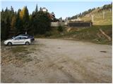
A) From the Ljubljana–Jesenice motorway, take the Vodice exit, then continue driving to the first traffic-light intersection in Vodice, where continue left towards Cerklje na Gorenjskem and Brnik. When we arrive at the main roundabout in Spodnji Brnik, continue driving towards Cerklje and Krvavec ski centre. At the end of the settlement Cerklje na Gorenjskem, leave the main road which continues towards Velesovo and Visoko, and continue driving slightly right onto the road towards the Krvavec ski centre. Further on, arrive at the village Grad, where signs for the settlement Ambrož pod Krvavcem direct us right onto a steep asphalt road (straight to the lower station of the Krvavec circular-cable car and Štefanja Gora). When the steepness on the steep road eases somewhat, we arrive at an intersection, where we continue left towards the settlement Ambrož pod Krvavcem (straight to settlements Ravne, Apno and Šenturška Gora). A little further, the road temporarily descends slightly, then ascends through occasionally quite scenic slopes. Higher up, we arrive at Ambrož pod Krvavcem, where we bypass the church of St. Ambrož and the tourist farm Pr Ambružarju on the left side. From the tourist farm onwards, the road enters the forest and ascends through it all the way to mountain pasture Jezerca, where there is a large arranged parking lot. Here the road flattens and turns left, about 500 m further it brings us to an intersection, where we continue right towards mountain pasture Kriška planina (straight to upper station of the circular-cable car and Planinski dom na Gospincu). There follows only a short steep ascent and we arrive at the parking lot at the edge of mountain pasture Kriška planina.
Now the road from mountain pasture Jezerca to Kriška planina is closed to public traffic; this extends our route by about 15 minutes.
B) From the Jesenice–Ljubljana motorway, take the Kranj–east exit, then continue driving towards Brnik, Komenda and Mengeš. When we arrive at the main roundabout in Spodnji Brnik, continue driving towards Cerklje and Krvavec ski centre. At the end of the settlement Cerklje na Gorenjskem, leave the main road which continues towards Velesovo and Visoko, and continue driving slightly right onto the road towards the Krvavec ski centre. Further on, arrive at the village Grad, where signs for the settlement Ambrož pod Krvavcem direct us right onto a steep asphalt road (straight to the lower station of the Krvavec circular-cable car and Štefanja Gora). When the steepness on the steep road eases somewhat, we arrive at an intersection, where we continue left towards the settlement Ambrož pod Krvavcem (straight to settlements Ravne, Apno and Šenturška Gora). A little further, the road temporarily descends slightly, then ascends through occasionally quite scenic slopes. Higher up, we arrive at Ambrož pod Krvavcem, where we bypass the church of St. Ambrož and the tourist farm Pr Ambružarju on the left side. From the tourist farm onwards, the road enters the forest and ascends through it all the way to mountain pasture Jezerca, where there is a large arranged parking lot. Here the road flattens and turns left, about 500 m further it brings us to an intersection, where we continue right towards mountain pasture Kriška planina (straight to upper station of the circular-cable car and Planinski dom na Gospincu). There follows only a short steep ascent and we arrive at the parking lot at the edge of mountain pasture Kriška planina.
Now the road from mountain pasture Jezerca to Kriška planina is closed to public traffic; this extends our route by about 15 minutes.
Route description:
From the parking lot, head onto the road towards planina Koren. The road then leads us through an underpass to a quarry, where we leave it. Continue the ascent on a pleasant but poorly visible mountain path that runs along the edge of the pasture fence. The path, which becomes more visible, then leaves the grazing areas of Kriška planina and enters terrain overgrown with dwarf pines. After a short ascent, the path brings us to a nice vantage point from which a fine view opens onto the Korošica valley. Further on, the path begins to descend more steeply and after a few minutes we are already 60 m lower. The path then levels out and from the right, the path from the aforementioned valley joins us. Further, we cross a strip of forest, then the path starts ascending again. During the ascent, an unmarked path branches off to the left leading to sedlo Razor; we continue on the marked path, which after a further few minutes brings us to the southern part of planina Koren. The path then descends past the animal watering place to the shepherd hut on the planina.
Here at the hut, slightly to the right (southeast direction), a path branches off leading to planina Košutna. The path initially crosses the slopes almost horizontally, then brings us to a technically demanding spot. The path climbs steeply over a short rocky step, where fixed protections assist us. The path then flattens and brings us past a cross to planina Košutna, where there is a chapel and shepherd shelter.
Kriška planina – planina Koren 1:15, planina Koren – planina Košutna 20 minutes.

Photos:
 1
1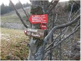 2
2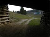 3
3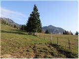 4
4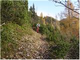 5
5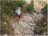 6
6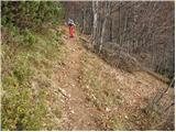 7
7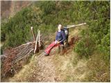 8
8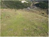 9
9 10
10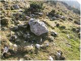 11
11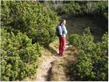 12
12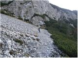 13
13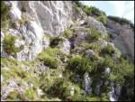 14
14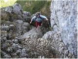 15
15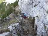 16
16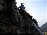 17
17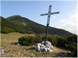 18
18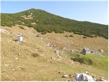 19
19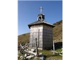 20
20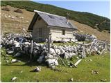 21
21
Discussion about the trip Kriška planina - Planina Košutna
|
| Gost20. 08. 2006 |
Beautiful excursion especially in autumn time. In winter, you avoid the crowds on Krvavec.
|
|
|
|
| Gost7. 09. 2007 |
How demanding is the technically difficult section, would it still be suitable for 6-year-old children?
|
|
|
|
| Gost7. 09. 2007 |
They are already somewhat used to climbing rocks, it would be okay, but they must not have fear of the steepness in front and the depth below. This part of the path is not long, it doesn't seem exposed to me, but it's quite steep, rocky, hands need to be used.
Some supposedly drag 6-year-olds even on the very demanding and exposed path to Mangart, so probably those few meters with a little help wouldn't be a problem for a 6-year-old.
|
|
|
|
| kanjavec2. 12. 2008 |
The trip is very nicely described and the path is also shown pictorially. I have walked the mentioned path several times both up and down. I warmly recommend the path for younger hikers only in the summer period.
|
|
|
|
| jprim2. 12. 2008 |
On this section, which I walked 14 days ago, it is necessary to renew at least the signs, if not all markings, because on the rocks you simply can't read anything, except guess, well, if the trail is not new to you, then you know how, otherwise you stray a bit from the right path ... and end up somewhere else.
Best regards
|
|
|
|
| pohodnica5326. 03. 2009 |
The trail is wonderfully depicted, so it really draws you in; due to vertigo I'm wondering if it's impossible to bypass this "technically demanding part" at all; is it just a very steep ascent (how many m), or is it accidentally also exposed on the side , I'd go only when there's no more snow anyway; thanks for the information , I'd go only when there's no more snow anyway; thanks for the information
|
|
|
|
| Biser gora27. 03. 2009 |
It's a steep, well-protected trail that ends with a short and slightly exposed ledge.
The mentioned part can also be bypassed by continuing from Planina Koren towards Kompotela and turning right higher up towards Košutna.
|
|
|
|
| pohodnica5327. 03. 2009 |
thanks for the advice; so I don't panic, I'll rather use the other variant towards Kompotela and if I understand correctly, I'll still reach the goal of Planina Košutna; this portal is really great and friendly hikers; now I'm not so worried that I'd get stuck somewhere because of fear of  precipices, because I get such information beforehand; otherwise I really enjoy the mountains; precipices, because I get such information beforehand; otherwise I really enjoy the mountains;  thanks again and have a pleasant hiking weekend to all who diligently browse, write and post pictures on hribih.net thanks again and have a pleasant hiking weekend to all who diligently browse, write and post pictures on hribih.net
|
|
|
|
| jprim29. 03. 2009 |
Well, if you take the direction towards Kompotela, it's better to continue to Kompotela, as the trail is not demanding and the views are even better. I myself continued from Košutna to Kompotela.
LP!
|
|
|
|
| jprim29. 03. 2009 |
I forgot to add that the starting point was elsewhere, namely at Markova ravnina.
|
|
|
|
| pohodnica5330. 03. 2009 |
Thanks to both for the information ; I hope for nice weather soon and that we can go on a hike; Lp ; I hope for nice weather soon and that we can go on a hike; Lp
|
|
|
|
| pohodnica5315. 07. 2009 |
simply put - wonderful path! Really paradise in miniature; started at Kriška planina, then to planina Koren, then to planina Košutna (yupi, I overcame the fear and went over "cable and pegs" - what a great feeling - and thanks Heinz for such encouragements), then to the top of Košutna - we got a bit lost in the scree because there are no markings - then to Kompotelo and circular back; really beautiful views - highly recommend to all who haven't yet stepped into this mountain paradise! - pictures next time - the photographer stayed home
|
|
|
To post a comment you must log in:
If you do not yet have a username, you must first
register.