Kranj (Kalvarija) - Šmarjetna gora (by road)
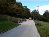
Starting point: Kranj (Kalvarija) (390 m)
| Latitude/Longitude: | 46,2399°N 14,3464°E |
| |
Route name: by road
Walking time: 40 min
Difficulty: easy marked way
Elevation gain: 256 m
Elevation difference along the route: 256 m
Map: Škofjeloško in Cerkljansko hribovje 1:50.000
Recommended equipment (summer):
Recommended equipment (winter):
Views: 34.190
 | 4 people like this post |
Access to starting point:
A) From Medvode or Škofja Loka, on the old road we get to Kranj, and then we descend to a roundabout, where the main road continues to the first exit right and then through a bridge over Sava, and we continue to the second exit in the direction of Besnica and Šmarjetna gora. Next follows driving through the underpass and sharp right turn, and then at the nearby crossroad, we continue sharply left in the direction of Šmarjetna gora. Further, the road steeply ascends, and then at the next crossroad we continue right, again in the direction of Šmarjetna gora and then we park at an appropriate place by the road.
B) From highway Ljubljana - Jesenice, we go to the exit Kranj - east, after that at all next crossroads we continue driving in the direction of Škofja Loka. When we get closer to the underpass, where the road goes towards Škofja Loka below the old road Ljubljana - Kranj, we continue right in the direction of Jesenice and Kranj and then after a short ascent, we join the mentioned old road, on which we continue towards Jesenice, and then we descend to a roundabout, where the main road continues to the first exit right and then through a bridge over Sava, and we continue to the second exit in the direction of Besnica and Šmarjetna gora. Next follows driving through the underpass and sharp right turn, and then at the nearby crossroad, we continue sharply left in the direction of Šmarjetna gora. Further, the road steeply ascends, and then at the next crossroad we continue right, again in the direction of Šmarjetna gora and then we park at an appropriate place by the road.
C) From highway Jesenice - Ljubljana, we go to the exit Kranj - west, and then we continue driving towards Kranj and forward towards Škofja Loka and Ljubljana. After the bridge over the river Sava, at the roundabout, we continue to the first exit right in the direction of Besnica and Šmarjetna gora. Next follows driving through the underpass and sharp right turn, and then at the nearby crossroad, we continue sharply left in the direction of Šmarjetna gora. Further, the road steeply ascends, and then at the next crossroad we continue right, again in the direction of Šmarjetna gora and then we park at an appropriate place by the road.
Route description:
From the starting point, we continue on the asphalt road which starts ascending on a slope named Kalvarija. The asphalt road, which makes a few hairpin turns and from which occasionally a view opens up towards Kranj and the Alps, brings us higher up below a small saddle, where the path splits.
To the left we can continue on a footpath or, higher up, a macadam road, but we continue on the asphalt road which from the slopes of Gradišče (592 m) passes to the slopes of Šmarjetna gora (643 m). We then follow the mentioned road, which is entirely asphalted, to the top of Šmarjetna gora, on which stand the church of St. Marjeta and hotel Bellevue. From the top, a beautiful view opens up towards the Alps and across Gorenjska.
Description and pictures refer to the condition in 2016 (October).
Photos:
 1
1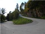 2
2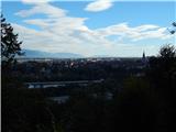 3
3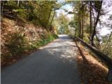 4
4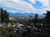 5
5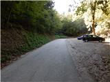 6
6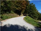 7
7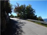 8
8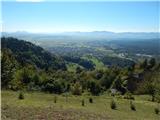 9
9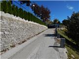 10
10 11
11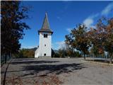 12
12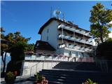 13
13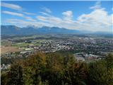 14
14 15
15
Discussion about the trip Kranj (Kalvarija) - Šmarjetna gora (by road)
|
| darh19. 06. 2011 |
You can also ascend to the summit from the western side via a much more pleasant footpath through the forest. You can read a more detailed description here.
|
|
|
|
| navrhu12. 03. 2016 |
Isn't there a catering place up there? Which hill is above Kranj, when looking from Kranj towards SW, you see a mighty building on the nearby hill. Tomorrow I would go up there, but I don't know how and where to start and what's up there.
|
|
|
To post a comment you must log in:
If you do not yet have a username, you must first
register.