Kraljev hrib - Gradišče (Velika planina)
Starting point: Kraljev hrib (540 m)
| Latitude/Longitude: | 46,3061°N 14,6088°E |
| |
Walking time: 3 h
Difficulty: easy marked way
Elevation gain: 1126 m
Elevation difference along the route: 1126 m
Map: Kamniške in Savinjske Alpe 1:50.000
Recommended equipment (summer):
Recommended equipment (winter): ice axe, crampons
Views: 79.219
 | 3 people like this post |
Access to starting point:
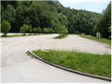
First, we drive to Kamnik, then we continue the drive in the direction of Kamniška Bistrica and the cableway to Velika planina. In Stahovica we continue left (direction Kamniška Bistrica and cableway Velika planina) and follow the moderately ascending road to a large parking lot near the lower cableway station to Velika planina (the parking lot is located on the right side of the road).
Route description:
From the parking lot, we continue on the road in the direction of the mountain pasture Planina Dol and Velika planina. After approximately 100 meters of walking on the road, just before the first right turn, we will notice on the left side initially a wide footpath which ascends into the forest (turn-off isn't marked). We continue on the mentioned path, which soon crosses a lane of bushes and immediately brings us to a junction, where we continue on the right path. Further, we ascend on a footpath which after a short ascent brings us to a forest road, which we follow to the left (unmarked).
After a minute or two of walking on the road, we come to the marked junction, where we continue right on a marked footpath. The path ahead first gently ascends among wild garlic growth, then it starts to ascend steeper and steeper. A relatively steep path, which runs through the forest the whole time, brings us higher to a short section that is exposed to falling stones. Further, the path ascends even steeper, then turns to the left, where the steepness eases. There follow only a few minutes of easy walking and the path brings us to a forest road, which we follow to the right. The road, which immediately emerges from the forest onto the western edge of Planina Dol mountain pasture, we follow for approximately 5 minutes to a marked junction, where we continue right - direction Velika planina towards shepherd huts on the mountain pasture (left Planina Rzenik and Konj), which we reach after a few additional steps of easy walking.
From the shepherd huts on the mountain pasture, past a cross we ascend to the edge of the forest, then continue the ascent on the path ascending through the forest. Higher the forest becomes sparser and the path after approximately 30 minutes of ascent from Planina Dol brings us to Planina Konjščica, from which a view opens towards nearby Rzenik.
We continue the ascent on a gentle, partly grassy path, which barely noticeably ascends towards the south. The increasingly scenic path, from which views open onto the central Grintovci, soon brings us to a forest road, where we reach an excellently marked junction. We continue right in the direction of the inn Zeleni Rob (left chapel Marije snežne, Domžalski dom, Črnuški dom...) on the road, which after 50 m of further walking brings us to the next junction. This time we continue on a cart track in the direction of "Rože vrhov", which steeply ascends past numerous shepherd holiday cottages. The path soon levels out and brings us to a grassy plateau, from which we can already nicely see the highest peak of Velika planina, which we reach after one minute of further walking.
In fog, orientation from Planina Konjščica to the summit is very difficult.

Photos:
 1
1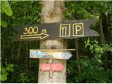 2
2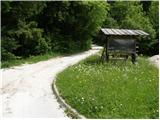 3
3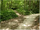 4
4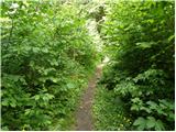 5
5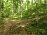 6
6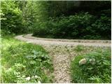 7
7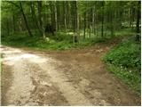 8
8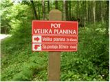 9
9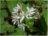 10
10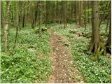 11
11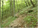 12
12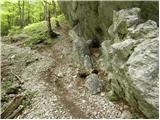 13
13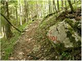 14
14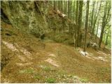 15
15 16
16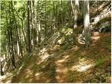 17
17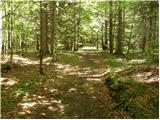 18
18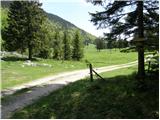 19
19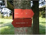 20
20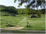 21
21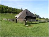 22
22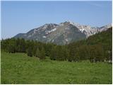 23
23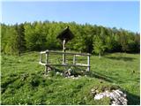 24
24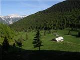 25
25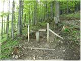 26
26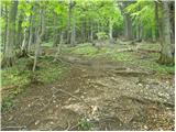 27
27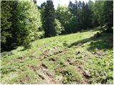 28
28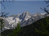 29
29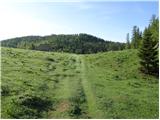 30
30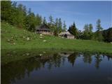 31
31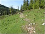 32
32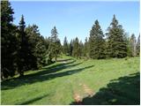 33
33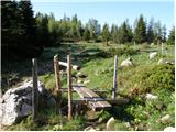 34
34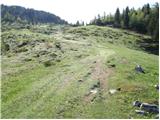 35
35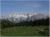 36
36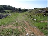 37
37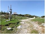 38
38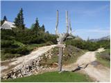 39
39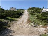 40
40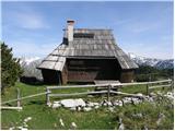 41
41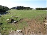 42
42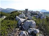 43
43
Discussion about the trip Kraljev hrib - Gradišče (Velika planina)
|
| klavdipo14. 08. 2008 |
Since I haven't seen any data anywhere, I'm interested if there's also a logbook and stamp at the top of Gradišče?
|
|
|
|
| maremw7. 12. 2008 |
today I went on this path, a bit below 1000 m you need to put crampons on to go up, snow hard, frozen, path excellent, views superb, a bit above Dol there was wading in the forest, which didn't spoil the beautiful impressions
|
|
|
|
| lovro4. 02. 2011 |
Hello!
Please, can someone write to me if it is possible to go safely on this path without crampons.
Thanks and best regards.
|
|
|
|
| tol4. 02. 2011 |
On this path they recently cycled downhill. So you can get to Velika planina without problems.
Probably even safer than the path čez Sv. Primož, which is icy in some places, because so trodden that it is very slippery.
|
|
|
|
| kontiki22. 08. 2011 |
I don't know which idiot wrote that it's an "easy marked path". Yesterday (21.8.2011.) I led a trip to Velika planina. When you start from the parking lot, there's a sign and direction for V. planina. We go along that road, no marks anywhere. We look at the map (Grintovci) - it shows we need to go left up. We reach the road. Where now? Probably up, right. We walk 20 min. no marks. We turn back. And then on a tree, among the branches, we notice a barely visible mark. We go left. Two Germans come, look at the map, and they also turn right, in the wrong direction! We dragged ourselves uphill for two hours on a difficult trail. When we reached the top, on the meadow, everyone collapsed from exhaustion. Further on there are new signs, but with directions that are not clear enough. When we had to descend from Črnuški dom to Krivčevo, we almost got lost. No marks anywhere. We went along the road, stopped cars, no one knows how to go down. In the end, a Slovenian guide who was in a house above the road to the dom na Kisovcu helped us. It took him some time to find the trail that steeply descends to Krivčevo. The marking starts only about 100m from the cow fence!
|
|
|
|
| kontiki22. 08. 2011 |
On this occasion, I would like to thank Mr. Radi Nadvešnik (forester and arborist from Ljubljana) who directed us to the right path to Krivčevo, so we arrived alive and well at the refreshment place "Pri Jurčku" and the bus waiting there.
|
|
|
|
| jprim22. 08. 2011 |
kontiki
I don't know which idiot wrote that it's an "easy marked path" ...
Before you led the group on the path, you should have informed yourself better about everything, printed the path description, and I think there wouldn't have been problems.
LP!
|
|
|
|
| NINICA27. 08. 2011 |
On Thursday 25.8. I took this path. Thanks to the path description and photos, I reached V Planina without problems.
Thanks!!!!
|
|
|
|
| kontiki6. 09. 2011 |
jprim
I read everything I found here about access to Velika Planina. Printed it. But on the ground I forgot about it. I relied on the markings (which have faded and overgrown in the branches). For me, who has walked the entire Slovak transversal, the path posed no problem. But for people with weaker fitness, real torment. From Črnuški dom towards the village Krivčevo there is not a single marking. They are gone. Only 100m from the road, in the deep pine forest, they suddenly appear. The one coming from Krivčevo has to work hard to find the exit from the forest and reach the road. There obviously a sign is missing.
|
|
|
|
| pohodnik3827. 02. 2012 |
Very easy path, on Saturday still a bit icy in the morning in places, otherwise a bit time-consuming at the beginning because it goes through the forest, but on Planina Dol it opens up and the views start, especially towards the central peaks of Kamnik Alps. It was nice, and also a short video on this link
|
|
|
|
| lakkon2. 05. 2012 |
Hello,
on Sunday I plan to go to the mountains for the first time this year and decided on this trail. First time.
Given that I have some experience - interestingly, mainly conquering 2000ers more in summer - and based on the pictures posted here, I'm wondering:
should I go in low hiking shoes or would it still be better to wear proper high hiking boots?
I know that for one's own safety (ankles, etc.) it's probably better to take the latter, but I'm still curious.
when I went to Trdinov vrh last May, I went in low ones and there were no problems. My buddy went - although I strictly advised against it - in regular 'sneakers', and he made it all the way without issues too.
otherwise, is everything OK on this trail currently? markings? is it excessively wet? mud?
thanks for the help.
|
|
|
|
| rjudnic2. 05. 2012 |
The trail is no more difficult or dangerous for the ankle than to Trdinov vrh from Gabrje. Make sure not to miss the junction shown here on the 4th picture, as it is not marked at all.
|
|
|
|
| dekovic6. 08. 2012 |
Yesterday was my first time on Velika Planina  my experience is very good and positive my experience is very good and positive  so I plan to go up again, as for the path I have to admit it's very well marked or I was lucky so I plan to go up again, as for the path I have to admit it's very well marked or I was lucky  Worth every minute, real balm for soul and body Worth every minute, real balm for soul and body
|
|
|
|
| Kigeot11. 10. 2014 |
Have they renewed markers or added path signs in the lower part in the last couple of years? Next week we'd go on this path, but I've had a case where I simply couldn't find the start or the right path because it wasn't sufficiently marked.... Thanks!
|
|
|
|
| Bellerophon30. 08. 2015 |
Yesterday I went through this path. After quite a few years of break, with new hiking boots, with the intention to break them in a bit. That was also the reason I was looking for a path marked as easy.
The first thing I thought of when I reached the forest road leading to Dol was the same as our colleague kontiki a bit higher in the comments.
The path is by no means easy, nor would I classify it as marked (rather poorly marked). Unfortunately, a bean must be called a bean, and even though someone was so good as to write a path description, that's no reason why it shouldn't be criticized, especially in matters like hiking, where such a misleading description can mean at least an injury, if not something worse.
I definitely advise against the path for beginners, as well as for older people and children, because it is poorly marked, and on some sections even very poorly passable or dangerous. As for the descent, it's the same, or maybe even a bit worse, because it's a descent after all.
In short, for someone who has some mileage behind them and is in a hurry to Velika Planina, the path is OK, others rather look for a "super easy" path, judging by how path difficulty is rated on this side.
And also, the real view opens up only when you arrive at Dol, the previous, most difficult part of the path is by our standards "ordinary scrub", without views of course or whatever you manage to glimpse through the dense crowns. 
|
|
|
|
| iUnknown31. 08. 2015 |
Sorry, but this path is actually easy.
In fact, there is nothing worse than going to a slightly elevated Šmarna Gora - this applies up to Planina Dol.
I first remember that we hiked it when we were still kids from elementary school, my sister was even before the first grade - of elementary school.
But if you have a problem with navigation, you need to take a map with you, even better if you have some good navigation app on your phone.
|
|
|
|
| karantanka9. 11. 2015 |
Some snapshots from Saturday's "walk" to Velika planina.
I started at the lower station of the cable car (currently not operating), where a sign nicely directs you to the right path but already at the next intersection you start wondering where to go next, as markings and signposts disappear.  It continues similarly at the next few intersections with the road and forest paths until with more luck than sense I finally spot the second directional sign. This part really needs better marking!!! I stuck to the forest road, which after about 1 km of walking starts to descend gently, and it leads you to a junction with a sign telling you it's 2:45 to the top of VP. From there on, I had no navigation issues. The trail is steep (to planina Dol) but not demanding. In wet conditions, it can be slippery like any other. When you leave planina Dol, where it says 1:15 to VP (let's say about 45 min really), it gets steep again briefly then you're already at planina Konjščica, where the peaks of Kamniško-Savinjskih Alp appear for the first time. Then it's just pure enjoyment... It continues similarly at the next few intersections with the road and forest paths until with more luck than sense I finally spot the second directional sign. This part really needs better marking!!! I stuck to the forest road, which after about 1 km of walking starts to descend gently, and it leads you to a junction with a sign telling you it's 2:45 to the top of VP. From there on, I had no navigation issues. The trail is steep (to planina Dol) but not demanding. In wet conditions, it can be slippery like any other. When you leave planina Dol, where it says 1:15 to VP (let's say about 45 min really), it gets steep again briefly then you're already at planina Konjščica, where the peaks of Kamniško-Savinjskih Alp appear for the first time. Then it's just pure enjoyment...
|
|
|
|
| Enka22. 05. 2016 |
Followed this description and the pictures and by searching for the path at the beginning where it is not marked, there were no problems.
|
|
|
|
| ivana230310. 04. 2024 18:49:22 |
It's not "easy", at least not for the average hiker, and even less a "marked path". At one point you reach a very steep ascent with scree, which is mentioned in the text, but without an app and map we would never have managed. There are no marks, at one moment we really thought we had messed up the trail, but then we reached the cable, meaning human foot has indeed stepped that way. Personally a nice and interesting ascent for me, but not for someone without hiking experience.
|
|
|
|
| lijaneja11. 04. 2024 16:24:50 |
I believe you had troubles, especially after last August. But there is no very steep ascent anywhere, as you mention. I was on this path many times during COVID, especially in summer it's great because it goes through the shade.
|
|
|
|
| serznoz24. 08. 2024 08:54:09 |
Ivana took a path not described on Hribi that leads to Velika planina via Kobilna dolina. The path is unmarked, but on the Locus map there's a trail that branches right into the northern slopes and precipitous walls of Velika planina somewhere in the middle at Dol at 1000m altitude. The path is poorly trodden but traceable, best with a digital map, and I'd rate it as very demanding. You mustn't get lost in such terrain, digital map is the solution. Its difficulty comes from exposed steep slopes, wet grasses that see no sun in August, scree on the narrow path with slip risk, steep gullies with piled rocks. At one point secured with worn rope. Notably, the path in zigzags is very gentle and altitude changes slowly.
|
|
|
|
| J.P.16. 12. 2024 18:24:00 |
Yesterday we went via planina Dol and Konščica to Gradišče and then (hoping for a nice loop path) returned via Sivnik. Sivnik is currently poorly traceable pathless terrain and in very poor condition so I advise against this path at the moment. Lp
|
|
|
|
| iUnknown18. 12. 2024 13:22:00 |
@J.P.
I drew the path through "Sivnik" myself and back then instead of the path name I entered a warning that someone can get lost quickly on this path. But someone thought it smarter to delete that warning and write "over Sivnik" as the name. And now no one knows anymore that this path is not for people with navigation problems.
But it's true that the path is indeed less traceable in places or disappears at one spot. Then you just have to stop and think a bit where you would place the path if you were laying it. That's how I found my way too.
|
|
|
|
| J.P.18. 12. 2024 19:55:21 |
#iUnknown, it mainly gets complicated due to fallen trees. A good part of the path we crawled under, over and between... shame that your warning was deleted. I hope these few sentences will now work instead of the deleted one
|
|
|
To post a comment you must log in:
If you do not yet have a username, you must first
register.