Koča pod Košuto - Koschutnikturm (Košutnikov turn) (ÖTK Steig Neu)
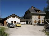
Starting point: Koča pod Košuto (1280 m)
| Latitude/Longitude: | 46,4517°N 14,3875°E |
| |
Route name: ÖTK Steig Neu
Walking time: 2 h 45 min
Difficulty: very difficult marked way
Via ferrata: B/C
Elevation gain: 853 m
Elevation difference along the route: 853 m
Map: Karavanke - osrednji del 1:50.000
Recommended equipment (summer): helmet, self belay set
Recommended equipment (winter): helmet, self belay set, ice axe, crampons
Views: 59.173
 | 5 people like this post |
Access to starting point:
Via the Ljubelj border crossing we drive to Borovlje / Ferlach, where we turn right towards the village Sele / Zell-Pharre. A little before the sign that marks the settlement Sele / Zell-Pharre, a road branches off to the right towards the Koča pod Košuto / Koschutahaus mountain hut. We follow this road all the way to the hut, where we park on a large parking lot.
Route description:
From the parking lot, we head southeast following the signs for Lärchenturm / Cjajnik, Koschutnikturm / Košutnikov turn. At the beginning of the path, we will also notice a large board with a picture of Košuta and precisely drawn paths to Cjajnik and Košutnikov turn. The path then runs through the forest towards the east for some time and brings us to a junction where the path to Cjajnik branches off to the right. We continue through the forest towards the east and in less than half an hour we reach another junction. We turn right following the signs for Košutnikov turn; straight, slightly downhill, the path leads towards the village Trkelj / Terkel. The path then ascends through the forest for some time and brings us to the scree slopes below the flanks of Košuta. After a short traverse to the east, we reach signposts where our path branches right and ascends somewhat more steeply across the scree. The left path continues to traverse the slopes towards the east. At this point, I should point out that the path leading to Košutnikov turn from the northeastern side is closed. After ascending the scree, we enter the climbing section of the path. From here on, we will need a helmet, and the use of a self-belaying device is highly recommended. The path steeply ascends the right side of the gully and brings us above the notch. The path is well secured with a steel cable throughout, and a few pegs assist us. Above the notch, our path turns right upwards; to the left (towards the north), above the notch, there is a hanging bridge over which we can cross to the other side of the notch. Our path does not cross the bridge but steeply ascends along the steel cable with the aid of a few pegs towards the south. On the left side, we can already see the precipitous northern wall of Košutnikov turn, followed by a shorter ascent along the steel cable to the main ridge of Košuta. Here we reach the less steep southern slopes of Košuta. We head left towards Košutnikov turn, and after a few meters, the western path from the Planina Spodnja Dolga njiva joins from the right. We continue along the southern side of the ridge and, on the path that becomes somewhat steeper, soon reach the panoramic summit.

Photos:
 1
1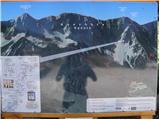 2
2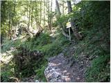 3
3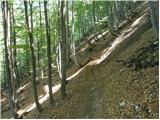 4
4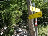 5
5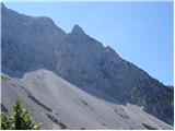 6
6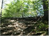 7
7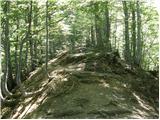 8
8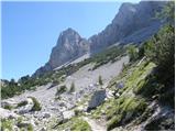 9
9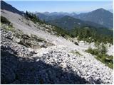 10
10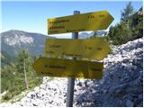 11
11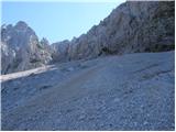 12
12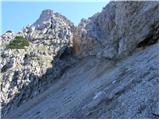 13
13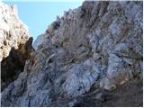 14
14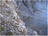 15
15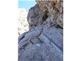 16
16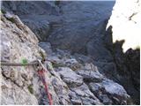 17
17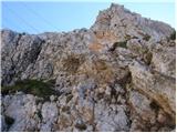 18
18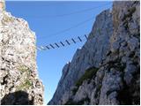 19
19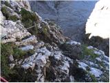 20
20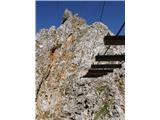 21
21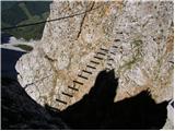 22
22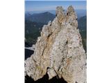 23
23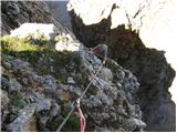 24
24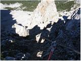 25
25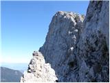 26
26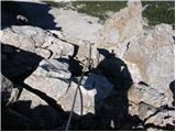 27
27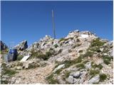 28
28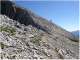 29
29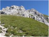 30
30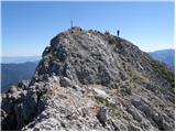 31
31
Discussion about the trip Koča pod Košuto - Koschutnikturm (Košutnikov turn) (ÖTK Steig Neu)
|
| Virenque21. 08. 2008 |
This bridge looks perfect! 
|
|
|
|
| Damijan23. 08. 2008 |
But that bridge looks really good. What are the gaps between the slats 
I almost started laughing when I saw it.
|
|
|
|
| janez7625. 08. 2009 |
Today I went up this path and it really is an incredible experience!
|
|
|
|
| acjom13. 09. 2009 |
Today I hiked this path, it's a unique experience both the path and the bridge. But I'm wondering if you can compare this path a bit with the Kopiščarjeva pot to Prisojnik. That one is still left for me this year, but I'm afraid it's really not much worse. Thanks and best regards
|
|
|
|
| draško13. 09. 2009 |
Perhaps the chimney in Kopiščarjeva is a shade more demanding, but go for it boldly. If it's not icy, it'll be fine, I recommend self-belaying.
|
|
|
|
| acjom13. 09. 2009 |
Thanks, I'll report after completing the path, hope this year, still before the snow.
|
|
|
|
| primo6. 07. 2010 |
hello. does anyone know what the current conditions are on this path? I'm mainly interested about the snowfields, if winter gear is still needed. thanks, best regards
|
|
|
|
| geppo6. 07. 2010 |
I think you can go without winter gear with a calm conscience!
Best regards
|
|
|
|
| bagi6. 07. 2010 |
No, winter gear is not needed, but full via ferrata gear is required. This mandatory includes a helmet, as the entry part of the via ferrata up to the branch to the hanging bridge is exactly under the upper part of the path. The terrain is crumbly and on Saturday quite a few projectiles whistled past the head  . If you go over the bridge you avoid that part. The entry to the bridge is at the foot of the adjacent hill a little to the left of the classic approach. It's an experience in itself and I warmly recommend it. Climbing gloves are also recommended to avoid blisters from gripping the cable . If you go over the bridge you avoid that part. The entry to the bridge is at the foot of the adjacent hill a little to the left of the classic approach. It's an experience in itself and I warmly recommend it. Climbing gloves are also recommended to avoid blisters from gripping the cable  and a self-belay set, which will come in handy especially on the descent. and a self-belay set, which will come in handy especially on the descent.
LP Bagi
|
|
|
|
| primo6. 07. 2010 |
thanks to both. helmet and protection will be there. without it I wouldn't dare go near. the bridge is also planned. best regards
|
|
|
|
| bagi6. 07. 2010 |
Don't worry about the bridge. It is fully equipped and secured (adrenalinic of course ) and not like you see it in the original post. Unfortunately I can't attach newer photos to *Commented trips*, but you can take my word for it. But it's still not a walk
|
|
|
|
| primo7. 07. 2010 |
Can you make a little comparison with Kopiščarjeva on Prisank. Length, difficulty?
Thanks, lp
|
|
|
|
| geppo7. 07. 2010 |
I haven't gone via Kopiščarjeva so I can't compare.
I've done this one to Košutnik twice. Actually, only one part is a bit harder and that's at the bridge (a few meters). Then it's easy.
Ultimately, you'll find that it's a short via ferrata. When you're warmed up a bit, you're already out of the wall.
More than anything, this path is quite frequented and consequently, stones falling from above!!!
I recommend gloves (even though I did it twice without them) - now I've got some!
They also protect you a bit from the debris that usually flies down the wall.
Lp
|
|
|
|
| bagi7. 07. 2010 |
Kopiščarjeva on Prisank is comparable to ÖTK Steig Neu in terms of difficulty, but not in the key sections. On ÖTK, this spot is open, airy, and vertical. It starts under the bridge and continues around the wall to the upper anchor of that bridge. However, as Geppo already mentioned, in the end it's all quite short. The rest has already been said. If you climbed Kopiščarjeva without issues, you'll manage this too. Weather will be nice over the weekend, just go and we'll read about it.
LP Bagi
|
|
|
|
| primo7. 07. 2010 |
super, thanks. on Saturday we'll go then rate the tour. tomorrow for gloves - everyone recommends them. lp
|
|
|
|
| geppo7. 07. 2010 |
OK primo
a colleague is also taking me to this area on Friday - Cjajnik!
Lp
|
|
|
|
| kavkec12. 08. 2010 |
Last Monday I went via ÖTK Steig Neu over the bridge. Really super thing. The entire path is excellently secured, so fear is unnecessary. Well, in some places, especially before the entry and after exiting the bridge, it is quite airy and exposed. For the helmet, I can say it is quite obligatory, as the terrain is fairly crumbly and there's no sense in tempting fate unnecessarily. I also recommend a via ferrata set.
|
|
|
|
| vik30. 09. 2011 |
Is it possible to traverse the ridge from Košutnikov turn towards Veliki vrh (Košuta)?
|
|
|
|
| JusAvgustin30. 09. 2011 |
I-II from less demanding to very demanding marked paths, approx. 11km, from 8 hours onwards... Climbing ridge. Hope I helped...
|
|
|
|
| vik1. 10. 2011 |
Thanks. This morning from Koča pod Košuto via OTK up to Turn, then from it traversed ridges up/down all to Veliki vrh, then down to Kofce koča, Matizovec, where logisticians (neighbor and son moved the car. All together a bit more than 8 hours, about 10, but really royal tour, phenomenal views. Behind Košuta cordillera always Triglav with wife, on the right all the way to Grossglockner tip, on the left between Grintovec and Storžič always our inland Snežnik. And everything else,... reviewing about 500 photos. May there be more such days.
|
|
|
|
| Janez Kastrevc4. 11. 2011 |
What are the conditions like on this tour? Would tomorrow be suitable to go up??
|
|
|
|
| matjaz8427. 06. 2012 |
Can anyone tell what would be the best descent variant from the Turn back to the Koča pod Košuto. I mean some slightly easier variant?
|
|
|
|
| primozs9. 07. 2012 |
Yesterday I was up on the summit. Nothing special.
Ascent to Cjajnik is prohibited, or rather the path is closed from 7.7.2012
|
|
|
|
| matjaz849. 07. 2012 |
I was at the summit via this path on Saturday. The initial part of the path towards Vilicami was accompanied by constant rumbling in the wall due to fresh rockfall. At the entrance to the climbing path, there was a real jam because a group of "hikers" reconsidered the ascent after the first 50 m due to excessive difficulty. I descended through the eastern gully. The path is very crumbly and you constantly dislodge rocks beneath you, so I can't imagine multiple people using the path for descent at the same time. Otherwise, new fixed protections (chains and steel cables) are installed, so it's not technically demanding. The best part is the scree slope after exiting the couloir anyway.
|
|
|
|
| tagec31. 08. 2012 |
Yesterday with Nina too tired for Cjajnik, reserve is OTK Steig Neu and both thrilled with the tour. Took 1.5 hours to the wall entrance, around the bridge seemed the hardest part to me - crumbly and exposed, then easier part and soon exit to the saddle, and summit. A bit unusual descending via ferrata, especially when meeting ascenders, but that's basically the only way up and back down to Austria. Descent was much easier, highly recommend SV kit, especially for the psyche. The most adrenaline was crossing the bridge, or realizing how to switch the carabiner from the lower cable to the upper one, then it went and descent from the notch pure pleasure, as it's really well protected! Recommend...
|
|
|
|
| IgorZlodej31. 08. 2012 |
Of course it's not the only way, descent is also possible through the eastern gully, see description under "Forum-conditions" Košutnikov turn.
|
|
|
|
| tagec1. 09. 2012 |
Igor, thanks for the info!! I knew there was an eastern path (I missed your description on 17.8.), but I heard it's very crumbly, especially downhill (I see matjaz84 did it!), so I thought the path was abandoned, but I was wrong & apologize. I often notice that the path description is only for uphill and then stops, so from other portal users you learn about other options! So Nina and I were on Stol 14 days ago, via the climbing path, quite nice path, it seemed undemanding to us, downhill we went on the western side, so via the scree which you see from the via ferrata and in one hour we were from the top of Stol to the road, instead of the much longer path via Beljščica mentioned in the description. But that's already an individual's decision and responsibility... Best regards
|
|
|
|
| ljubitelj gora24. 10. 2012 |
These are two paths, one goes over the little bridge, the other doesn't, ideal for a circular route.
|
|
|
|
| DARINKA529. 07. 2013 |
How is the walking across the hanging bridge, does it sway a lot? Is it possible to return to the starting point entirely via a different path?
Thanks
|
|
|
|
| Antonija.Kriselj29. 07. 2013 |
Walking across the bridge is completely safe with proper use of the safety harness, but the secured path to Košuta Haus also goes past the bridge.
|
|
|
|
| ljubitelj gora30. 07. 2013 |
The bridge sways when you step on the wooden part, you grab the steel cables, move, everything swings, not too much, but just enough to instill fear in your bones. For the full loop via Cjajnik I needed 5 hours, normal climbing-walking is about 8 hours. The ascent over the scree under the bridge and to the top of the Košuta ridge is short.
Parking at the hut costs 4 euros and is paid at the hut.
|
|
|
|
| felix1. 08. 2013 |
Is the path to Košutnikov turn from the NE side still closed?
Thanks and best regards.
|
|
|
|
| jelka1001. 06. 2014 |
Maybe someone knows what the conditions are from the hut direction to the Košutnikov turn climbing path??
|
|
|
|
| felix23. 06. 2020 |
Interested in conditions on this trail (safety gear, snow)?
lp
|
|
|
|
| čebejla23. 06. 2020 |
Just saw a post that everything is normally passable
|
|
|
|
| fjr13. 07. 2020 |
On Friday 10.07. I completed this trail. The trail is wonderful except for the rather long scree slope. The via ferrata section itself is quite exposed and quite adrenaline-filled. Wonderful views from the summit. I RECOMMEND to all via ferrata enthusiasts.
|
|
|
To post a comment you must log in:
If you do not yet have a username, you must first
register.