Konec ceste na Pokljuki - Veliki Draški vrh
Starting point: Konec ceste na Pokljuki (1312 m)
| Latitude/Longitude: | 46,3386°N 13,9045°E |
| |
Walking time: 2 h 45 min
Difficulty: partly demanding unmarked way
Elevation gain: 931 m
Elevation difference along the route: 931 m
Map: Triglav 1:25.000
Recommended equipment (summer):
Recommended equipment (winter): ice axe, crampons
Views: 68.310
 | 6 people like this post |
Access to starting point:a) Leave the Gorenjska motorway at the Lesce exit, then follow signs for Bled and Pokljuka. Continue through Gorje and past the Zatrnik ski slope to Rudno polje on Pokljuka, where there is a large paid parking lot, nearby a military barracks and shooting range. From here continue straight on the gravel road, which a bit further leads to a junction, where we continue right (left Uskovnica). Follow this road to the former parking lot Za Ribnico, located at the end of the road (nearby are mountain signs for planina Konjščica).
Parking at the end of the road is now prohibited, so park at Rudno polje, which extends the route by about 40 minutes, but it is more appropriate to choose the marked path that starts already at Rudno polje.
b) From Železniki or Podbrdo drive to Bohinjska Bistrica, then continue driving towards Bled. Shortly after the Petrol gas station, located just beyond Bohinjska Bistrica, continue left towards Pokljuka and Jereka. The road first climbs steeply, then gradually levels after Koriti and takes us to a junction at the bus stop, where we continue right towards Pokljuka, Koprivnik and Jereka (straight Srednja vas). Immediately after the junction we arrive at Jereka, but from the junction in front of the church continue straight towards Pokljuka (left Podjelje). After Jereka the road starts climbing more steeply again, higher it levels and continues along Mrzli potok. When joining the road from Bled go left and drive to Rudno polje, where there is a large paid parking lot, nearby a military barracks and shooting range. From here continue straight on the gravel road, which a bit further leads to a junction, where we continue right (left Uskovnica). Follow this road to the former parking lot Za Ribnico, located at the end of the road (nearby are mountain signs for planina Konjščica).
Parking at the end of the road is now prohibited, so park at Rudno polje, which extends the route by about 40 minutes, but it is more appropriate to choose the marked path that starts already at Rudno polje.
Traffic regime in the Pokljuka and Uskovnica area from 15.6. to 15.10.
Route description:
From the former parking lot at the end of the road continue on the wide and initially ascending track towards planina Konjščica. The track, which enters dense forest immediately, soon levels out and after a few minutes of easy walking turns into a footpath continuing along the left bank of the Ribnica stream. When the path gets very close to the stream it turns slightly right and ascends more steeply. Higher up the path levels and leads us from the forest to the lower edge of the vast planina Konjščica. Here the path turns slightly left, crosses a streamlet and after a few more steps brings us to the cheese dairy on planina Konjščica.
From the cheese dairy continue on the pleasant path that in a few minutes of gentle ascent brings us to the upper edge of the planina. Here the path enters the belt of dwarf pines and shrubs and gradually begins to ascend more steeply. In the upper part of the ascent to Jezerce the path from Rudno polje joins from the right, we continue straight on the moderately steep path that in a few more minutes of walking brings us to Jezerce, where the path levels and turns left (here the path to Srenjski preval branches right).
Follows easy walking to a sign indicating the central area of TNP, then the path begins to ascend moderately along a torrent, initially still a streamlet. Higher the path switches to the right side of the torrent, viewed from the direction of ascent, and then ascends transversely to Studorski preval, where the demanding path from Srenjski preval joins from the right.
From Studorski preval continue right (left Ablanca, straight Vodnikov dom, sharp right Srenjski preval) on the initially gentle path ascending through the dwarf pine belt. Somewhat further the path turns left and gradually starts ascending ever steeper. After a few more minutes of walking the path brings us below a short but quite steep rocky step, which we "overcome" with a little hand assistance (mainly for balance). The rocky step is exposed not only to the risk of slipping but also to falling rocks (caution!). Higher the path levels and leads to a very scenic and technically mostly undemanding ridge. The path, from which beautiful views open to the Bohinj-Tolmin mountains (sometimes called Lower Bohinj mountains) and other Bohinj mountains, shortly below the summit starts ascending steeply again. The path further ascends over a short and steep stony slope, then levels and in a few more minutes of walking brings us to the scenic summit.
Starting point - Planina Konjščica 0:30, Planina Konjščica - Klanci 0:40, Klanci - Jezerce 0:05, Jezerce - Studorski preval 0:30, Studorski preval - Veliki Draški vrh 1:00.

Photos:
 1
1 2
2 3
3 4
4 5
5 6
6 7
7 8
8 9
9 10
10 11
11 12
12 13
13 14
14 15
15 16
16 17
17 18
18 19
19 20
20 21
21 22
22 23
23 24
24 25
25 26
26 27
27 28
28 29
29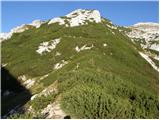 30
30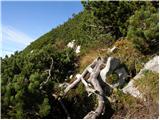 31
31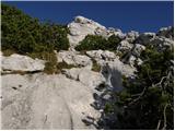 32
32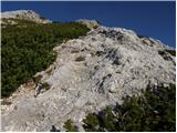 33
33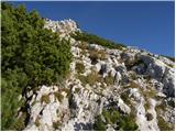 34
34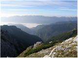 35
35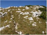 36
36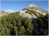 37
37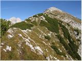 38
38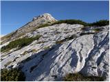 39
39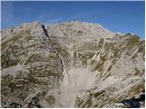 40
40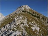 41
41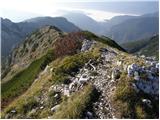 42
42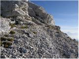 43
43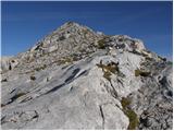 44
44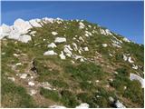 45
45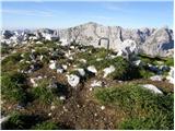 46
46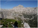 47
47
Discussion about the trip Konec ceste na Pokljuki - Veliki Draški vrh
|
| Gost10. 09. 2006 |
The trip to Veliki Draški vrh is very interesting due to the beautiful view of Triglav and other mountains :)
The start of the path from Studorski preval is dangerous due to falling rocks so you have to be careful and walk slowly
The descent to the other side (towards Lipanci) was steep but almost better regarding falling rocks 
|
|
|
|
| Gost22. 09. 2006 |
I did the described tour and can fully confirm all statements. The warning is particularly valid for the ascent through the rocky jump and even more so when pushing through the scrub. The descent on this section is even more tricky. One must be very careful.
|
|
|
|
| Gost5. 08. 2007 |
Today I completed the tour and completely agree with the two comments above. The first part of the path requires great caution and of course care not to miss the path. For the initial part through the brush, long pants are recommended. I descended to the other side to the path to Lipanco and from there directly to Jezerca. This path is really steep but much easier than from Studorski preval.
|
|
|
|
| Gost14. 08. 2007 |
I'm wondering if descent from Veliki Draški vrh to Vodnikova koča is possible and how much time it approximately takes for such a path from Studorski preval to the koča. Thanks.
|
|
|
|
| Gost14. 08. 2007 |
The path from Veliki Draški vrh leads to Srenski preval below Mali Draški vrh and is not for those with vertigo. The path is narrow, exposed, steel cable only in some places. It's for experienced hikers.
|
|
|
|
| urshy22. 09. 2009 |
Does anyone perhaps know what the path from Viševnik over Mali and then to Veliki Draški vrh is like?
|
|
|
|
| Miha817. 02. 2010 |
Starting point: End of the road on Pokljuka (1340 m)
Goal: Veliki Draški vrh (2243 m)
I'm wondering what the path is like for tomorrow? Is it trodden? I haven't been to Veliki Draški vrh in winter yet, so I would be very happy for your information.
|
|
|
|
| Miha817. 02. 2010 |
Thanks for the link and information. Now I know not to go anywhere into the high mountains until it's safe.
Best regards
|
|
|
|
| colinbrooks24. 07. 2010 |
A trip to Veliki Draski Vrh
A magnificent circular tour on spectacular but easy paths with dramatic views including possibly the best view of Triglav from anywhere in the Julian Alps. Easily accomplished from Ljubljana in one day.
9.40-11.10. A first class road from just before Bled leads to the sport hotel at Pokljuka then past the new winter sports centre. From there follow the continuing macadam road for about 2km to the parking lot where the road ends at Rudno Polje. Total driving time from Lj 1.5h
11.10-11.50. Follow the track that leads gently upwards to the alpine pasture at Planina Konjscica where you can sample and buy the locally made cheese. Time 30min
11.50-1.15. After crossing the meadows at Konjscica, the path leads uphill through pine scrub to a large corrie with snow persisting until the end of June and with dramatic views of M. Draski Vrh and Visevnik. The path leading down from the ridge between them, that will be the route of descent later in the day, can be clearly seen. It looks much more forbidding, especially at the top, than it turns out to be in practice. The path that leads across the steep face of M.Draski Vrh can also be faintly seen if you know where to look. From the corrie the path then resumes its upward course before reaching the spectacular ridge at Studorski Preval which provides an excellent spot for lunch. Time 1.5h.
1.45-2.45. The unmarked path recommended in the guide heads off to the right [NW] in a clear passage through dense pine scrub and up a bulging rock face which is actually the start of a ridge leading to the hidden summit of V.Draski Vrh. The very beginning of this path is quite tricky, being on the edge of a steep descent to the left and is probably the most difficult part of the tour.
[Unmentioned in the guidebooks, and not readily visible on the ground, another path leads off roughly horizontally to the north from S.Preval, passing to the right and below the bulging rock face before gradually ascending to the col between Veliki and Mali Draski Vrh, from which an indistinct but easy path that will be used for descent in this trip (see below) goes off to the left to the summit of V. Draski Vrh.]
Once over the bulging rock face an easy path ascends the ridge to the summit with increasing views of the Triglav satellite of peaks. From the summit the view of the Triglav massif falling precipitously down into the deep Krma valley is unparalleled. On a clear day one could linger here for hours! Time 1h.
3.30-4.30. From the summit a winding and somewhat sporadic path leads down over easy ground and in a NE direction to the col between Veliki and Mali Draski Vrh. During the descent the path that leads spectacularly across the face of M.Draski Vrh can be clearly seen. It appears to enter dangerous territory at its end near the ridge between M.Draski Vrh and Visevnik but in fact there are no problems for experienced walkers especially as this part of the path is equipped with fixed ropes and pegs. For those who feel anxious a good path leads from the col to Studorski Preval [see above]. Time 1h.
4.30-5.15. The path across the face of M. Draski Vrh begins by ascending over easy ground. At the very start it runs along the edge of the precipitous cliffs that fall almost 1000m into the Krma valley, providing spectacular views of these [but keep away from the very edge as the ground is unstable here]. The path eventually narrows and continues horizontally before reaching the "difficult" section mentioned above. The drop-off to the right is steep but rarely precipitous, and for the careful walker this is a joyous, spectacular, and beautifully engineered path with dramatic views down to the corrie below. At the very end the path ascends to the left for about 100m up a steep chute of loose scree to a signpost on the summit ridge. This looks potentially dangerous from a distance, but in practice it is perfectly safe. Time 30 min.
5.30-7.40. After skirting the pinnacles along the ridge, in about 100m the path down to the corrie can be clearly seen. It is steep but not dangerous. From the corrie one retraces steps first to Konjscica [1h 15min] then to Rudno Polje [30 min].
|
|
|
|
| techouse15. 12. 2014 |
With a colleague we climbed yesterday first up one gully to Ablanco and then to Veliki Draški vrh. Conditions were quite serious, i.e. -5°C and wind gusts up to 96 km/h. Due to the icy spindrift visibility was only about 10 m and my goggles froze twice in between Both our faces got properly "frostnipped", the experience unique
|
|
|
|
| mukl9. 11. 2015 |
With friends we did this trail last Friday, 6.11., and then extended it with the path to Viševnik.
Because the weather was downright gorgeous and so warm for this time of year, we later regretted not starting earlier and doing first the ascent to Ablanco, then Tosc, Veliki Draški vrh, then Mali Draški vrh and finally Viševnik, well, next time...
Otherwise, wonderful views and sights of očaka, Planika and the hut at Kredarica were so close that I could almost grab them...
|
|
|
|
| nina42. 08. 2018 |
Is the road from Rudno polje to the starting point for planina Konjščica already open?
|
|
|
|
| cBojan2. 08. 2018 |
You can 'easily' park at the beginning but there is a lot of timber, the road is officially closed due to logging. At least it was the day before yesterday and yesterday.
|
|
|
|
| gulid236. 08. 2018 |
Until when will the road to the starting point be closed: Konec ceste na Pokljuki. I saw somewhere that until 16.8.2018?
|
|
|
|
| nina46. 08. 2018 |
On Sunday I checked the status. The closure sign was placed diagonally (not across the road, not fully aside either) so I didn't dare drive beyond the junction for the hiking path to Uskovnica. The braver ones drove the remaining 2 km without issue and parked at the end. The info on the Pokljuka website also mentions occasional closure. I conclude that the road is open on weekends, but during weekdays they will obviously be hauling huge quantities of wood already stacked along the road.
|
|
|
|
| Majdag2. 08. 2019 |
31.7... First from the end of the road on Pokljuka and also last. Road full of potholes filled with rainwater. That's still okay, but back part of muddy road with deep truck and car ruts. I was worried how I'd get through that mud. It worked. Otherwise, the rocky ridge from Studorski preval is interesting and varied. Lots of rhododendrons and Zois' violets along the path. At the top, fog swirling around the summits. Nice tour, except the road.
https://jelenkamenmajdag.blogspot.com/2019/08/veliki-draski-vrh.html
|
|
|
|
| Majdag2. 08. 2019 |
.. Sorry, Zois bellflowers are blooming along the path.
|
|
|
|
| Enka28. 06. 2022 19:37:33 |
The path to VDV is nicely followable and just interesting enough not to be boring. After 3 years, the alpine dairy at Konjščica is operating again, where one can refresh and support it. At Rudno polje there are signs prohibiting motor vehicle traffic towards Uskovnica and the end of the road at Pokljuka. Yesterday I, like several others, parked at the starting point anyway, but the question is how long that will still be possible (at Konjščica they say the ban does not apply yet, but it will ) )
|
|
|
|
| Alex19822. 09. 2022 15:51:56 |
I'm curious since the path is not marked... if it is well traceable... if maybe someone knows.. thanks for the answer
|
|
|
|
| garmont2. 09. 2022 16:03:08 |
It is marked only from Studorski preval onwards. Exactly at the pass, you turn right and continue along the path carved into the scree in the direction of VDV.
You won't have any problems with traceability.
|
|
|
|
| Alex19822. 09. 2022 16:09:15 |
Thanks for the reply garmont
|
|
|
|
| Alex19822. 09. 2022 16:27:57 |
How is it with parking there.. is it allowed or not.. maybe someone knows
|
|
|
|
| Hribolazec8114. 08. 2023 21:51:55 |
Hi, how is this starting point, can you still get there and park?
|
|
|
|
| turbo14. 08. 2023 22:26:22 |
Of course you can get there and park at the end too, it's just sad that it's forbidden. It was written in one of the neighboring sections a couple of days ago and equipped with a photo....
|
|
|
To post a comment you must log in:
If you do not yet have a username, you must first
register.