Starting point: Kocenpohar (785 m)
| Latitude/Longitude: | 46,2236°N 13,9595°E |
| |
Walking time: 2 h 45 min
Difficulty: easy marked way
Elevation gain: 1059 m
Elevation difference along the route: 1059 m
Map: Škofjeloško in Cerkljansko hribovje 1:50.000
Recommended equipment (summer):
Recommended equipment (winter): ice axe, crampons
Views: 29.538
 | 2 people like this post |
Access to starting point:
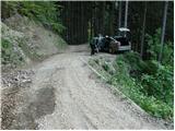
From Tolmin or Škofja Loka we drive to the village of Podbrdo (also possible by train or car shuttle train from Bohinjska Bistrica), where in the center of the village the road towards the village of Bača branches off. The asphalt road, which soon becomes very narrow, starts to ascend steeply and brings us to an intersection. At the intersection, we turn onto the left macadam road, which descends at the beginning and then starts to ascend again. The still very narrow road brings us to the fence at the Kocenpohar farm. A little before the fence there is a small parking lot for a maximum of two cars, so it is better to park already a little lower.
Route description:
From the parking lot, we continue on a steep road to the fence, which we cross, and on the other side we come to a meadow at the farm. We continue on the left side of the farm house, still on a rougher road. Our path again crosses the fence and then slightly descends to a stream, where there is a junction of two cart tracks. We head onto the left steep cart track, which crosses the stream and after a short ascent brings us to a smaller clearing at a decaying farm.
Further, we head right onto the cart track that goes into the forest and ascends moderately. The cart track brings us after 15 minutes from the decaying farm to a forest road. We follow this road all the way to Sedlo, where the path from the village of Kal joins (the road has a shorter shortcut along the marked path).
At Sedlo we head onto the path marked for Črna prst. The initially gentle path soon starts to ascend steeply up the steep vegetated western slope. In time, the path brings us to an indistinct ridge and continues along the eastern slope. When the path brings us back to the ridge, a beautiful view opens up. Here there is also a small bench that offers a well-deserved rest. The path ahead goes back into the forest and continues to ascend quite steeply. Soon the path approaches a viewpoint that is only a few steps from the path. Beyond the viewpoint, the path soon leaves the forest for the grassy slopes of Črna prst. Along the increasingly panoramic path there is plenty of alpine flowers. Since we are ascending sunny slopes, the climb is very strenuous in the middle of the day, so it is better to set off early. The path becomes somewhat less steep and brings us to the saddle Čez suha, where a beautiful view opens onto the Bohinj side.
Here at the junction we go left and reach the Dom na Črni prsti hut in ten minutes. From the hut to the summit, where the panoramic plaque stands, it is only a few steps.
Kocenpohar - Sedlo 45 minutes, Sedlo - Črna prst 2:00.

Along the route: Sedlo (985m)
Photos:
 1
1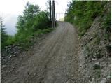 2
2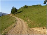 3
3 4
4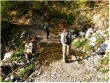 5
5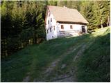 6
6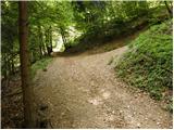 7
7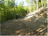 8
8 9
9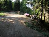 10
10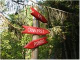 11
11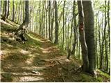 12
12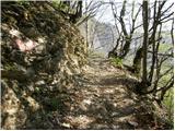 13
13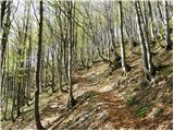 14
14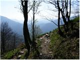 15
15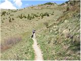 16
16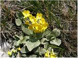 17
17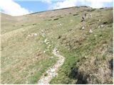 18
18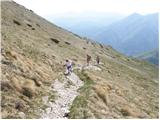 19
19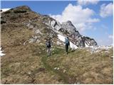 20
20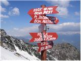 21
21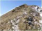 22
22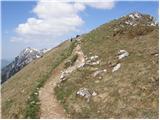 23
23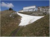 24
24 25
25
Discussion about the trip Kocenpohar - Črna prst
|
| Tadej2. 05. 2007 |
Currently closed. Usually opens in June.
|
|
|
|
| Gost17. 09. 2007 |
The path is suitable for the upcoming autumn days when there is already snow in the high mountains.
|
|
|
|
| Benč21. 09. 2008 |
Really clearly described path. You simply can't miss it. Only the road junction to that farm I didn't find right away.
Otherwise nice path and even nicer stroll 
Pictures
|
|
|
|
| NEIC00822. 05. 2009 |
What are the current conditions? Is there still any snow?
|
|
|
|
| Murglovc22. 05. 2009 |
From the Primorska side it's snow-free.
|
|
|
|
| Bojan_A2. 09. 2009 |
I'm interested if this is the path along which Ivan Anderle's mountain run to Črna prst takes place. I plan to participate in the race on Saturday and wonder if I'm looking at photos of the right track?
|
|
|
|
| Tadej3. 09. 2009 |
The lower part follows a different track, from Sedlo (985 m) onwards the path is the same as in the pictures.
Here the paths join.
|
|
|
|
| anemona19. 10. 2009 |
1. On Saturday 17.10. my husband and I went to Črna prst from Kocenpohar. About 10-15 minutes above the farm (picture 8) they were making a new road section. Where the marked entrance to the forest path used to be, there is now a 2m high sandy embankment, so we didn't find the entrance. At the newly created intersection there are no markings, so we went right on the new road and reached Sedlo by road. From there onwards it's marked and there are signs. Judging by the parked vehicles, Sedlo is reachable by car (from Kala?).
2. The owner of Kocenpohar farm is not enthusiastic about vehicles on the private road from the asphalt to the farm. The road is for one vehicle, there are passing places, but they are too narrow in case of meeting a truck or tractor with trailer (they deal with logging and transport). To avoid ill will on both sides, I recommend other starting points.
|
|
|
|
| anemona19. 10. 2009 |
Correction: at the newly created intersection there are no markings, so we went LEFT on the new road (not right) and reached Sedlo by road. (apologies)
|
|
|
|
| opazovalec26. 02. 2011 |
Winter access along the summer path from the village Kal nad Stržiščem is currently trodden. The upper part of the path was windy yesterday, at times stormy, but the view exceptional. Ice axe and crampons came in handy.
|
|
|
|
| Okmodko22. 09. 2011 |
Can someone tell me what the purpose of that puddle at Zorka Jelinčič's hut is? Probably not natural since it's on top of the hill, or is it? Hm strange thing
|
|
|
|
| Enka23. 09. 2011 |
I wondered the same when I was on Črna prst this year, but I don't know the answer. The only thing that came to mind was that maybe sometimes a sheep strays up from the coastal side . .
|
|
|
|
| ljubitelj gora31. 12. 2012 |
This forest road is currently drivable, if I had known earlier I would have left the car in the valley even that small parking spot before the stream is questionable. You never know what flies from that steep slope, the parking spot is deep below Kobla.
|
|
|
To post a comment you must log in:
If you do not yet have a username, you must first
register.