Koča pri jezeru Morsko oko - Rysy
Starting point: Koča pri jezeru Morsko oko (1410 m)
Walking time: 4 h 15 min
Difficulty: difficult marked way
Elevation gain: 1093 m
Elevation difference along the route: 1089 m
Map:
Recommended equipment (summer): helmet
Recommended equipment (winter): helmet, ice axe, crampons
Views: 9.663
 | 3 people like this post |
Access to starting point:
At the Lysa Polana border crossing between Poland and Slovakia, turn right before the bridge (towards Slovakia). After about a kilometre, there is a large car park on the right (990 m a.s.l.). If you arrive early, an 8.5 km path awaits from the car park along the Fish Brook Valley to the shelter at Morskie Oko Lake. If you arrive later, you can take a horse-drawn carriage to the start; they begin around 8 or 9 a.m. (no timetable, so no fixed times).
Route description:
From the shelter continue left along Morskie Oko Lake (you can also turn right, as the paths join). After 15 minutes of walking we reach the other side of the lake, where a short ascent (20 minutes) to Black Lake at 1580 m a.s.l. awaits.
From here to the summit is another 3 hours and 20 minutes. The level path leads us once more along the lake to the other end. From there the path ascends continuously. All the way to the intermediate point Bula pod Rysami (2054 m a.s.l.), from which there is a wonderful view of the lakes. We hike on rocky 'steps'. Ahead is still a good hour of secured walking equipped with chains. The summit is quite pointed and thus offers little space for resting.
Along the route: jezero Morsko oko (1410m), Črno jezero (1580m), Bula pod Rysami (2054m)
Photos:
 1
1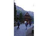 2
2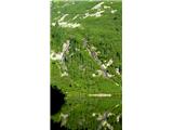 3
3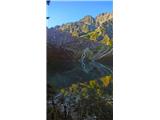 4
4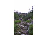 5
5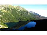 6
6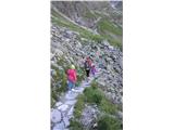 7
7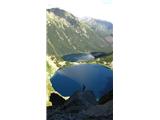 8
8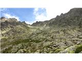 9
9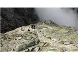 10
10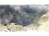 11
11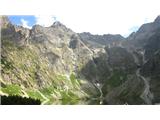 12
12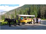 13
13
Discussion about the trip Koča pri jezeru Morsko oko - Rysy
To post a comment you must log in:
If you do not yet have a username, you must first
register.