Koča pod slapom Rinka - Koroška Rinka
Starting point: Koča pod slapom Rinka (1024 m)
| Latitude/Longitude: | 46,3696°N 14,5986°E |
| |
Walking time: 5 h
Difficulty: very difficult marked way
Via ferrata: B
Elevation gain: 1409 m
Elevation difference along the route: 1454 m
Map: Kamniške in Savinjske Alpe 1:50.000
Recommended equipment (summer): helmet, self belay set
Recommended equipment (winter): helmet, self belay set, ice axe, crampons
Views: 56.166
 | 5 people like this post |
Access to starting point:
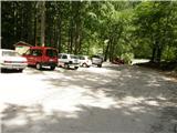
We drive to Luče (to here from Mozirje or over Kranjski rak) and onwards towards Logarska dolina. Soon after the village of Solčava we come to the junction, where the road to Logarska dolina branches off to the left. We turn left towards Logarska dolina (toll payment) and drive along the road to the parking lot at the mountain hut Koča pod slapom Rinka, where we park.
Route description:
From the parking lot, we head onto a wide tourist path that starts to ascend gently. After a good ten minutes of walking, we emerge from the forest, where we reach a junction. We head left (right to Orlovo gnezdo 3 minutes) in the direction of Dom na Okrešlju. The path ahead crosses a small bridge and on the other side starts to ascend more steeply. After a short ascent, the path brings us below the walls, from where a traverse to the top of the waterfall follows. This section is exposed to falling rocks. The path then crosses the Savinja again and ascends further along the river with the aid of steps. Next, we ascend on the right side (left bank) of the Savinja. Soon we reach the source of the Savinja, where we cross the water again. On the other side, the path enters a dense forest and after a short ascent brings us to the winter shelter on Okrešelj. We continue left and in a few steps reach the Dom na Okrešlju.
At the hut, we take the path in the direction of Kamniško sedlo and Savinjsko sedlo. Soon we reach the edge of a panoramic meadow, where there is a junction. We continue straight across the meadow in the direction of Češka koča and Kranjska koča (left to Kamniško sedlo). The path ahead crosses a torrent and then ascends gently beside the scree. Soon we reach the next junction, where the path to Turški žleb and the memorial branches off to the left, just a few dozen steps away. We continue straight through the increasingly narrow valley. The path starts to ascend more steeply and brings us below the walls of Mrzla gora. The path continues on the left side of the torrent, on a moderately steep grassy slope that is partly overgrown with dwarf pines. The path then crosses to the left side below the scree of Štajerska Rinka. In a traversing ascent, the path brings us below the walls, where there is a risk of falling rocks. A shorter steep pitch follows, then the path heads slightly right onto grassy slopes, where we reach a junction. We continue straight, while the path to Mrzla gora branches off to the right. Soon we reach another junction, where we head left onto the very demanding path marked Križ (straight leads the path toward Savinjsko sedlo). From the junction, the path ascends the scree and brings us to the start of the climbing section. The path then ascends a slightly gravelly slope, then turns slightly right and with the steel cable and the help of a few pegs traverses steep slopes in a gentle ascent. The path then turns slightly left and with the aid of steel cables and pitons ascends a fine passage and then several more times traverses very steep slopes along the steel cable. The path then brings us to a steep gully, up which we first ascend vertically on pegs and then continue steeply upward along the steel cable. The path then ascends steeply several more times along steep gullies, then brings us to a notch, where a view opens toward the Ledine. From the notch, we descend along the steel cable over gravelly terrain and reach a junction. We head left following the marks for Rinke, while right leads the path toward Ledine. The path ascends past a natural window and then turns slightly right and traverses steep western slopes in ascent. The path then turns left and ascends steeply along the steel cable. Soon we reach the northern slopes of the mountain and some easy climbing follows on rugged rock without fixed protection. We return to the western slopes, where the path once again ascends very steeply along the steel cable. From here there is also a very fine view of the sheer walls of Skuta. A quite exposed traverse follows on the western side of the mountain, then the path turns left again and ascends almost vertically along the steel cable. We reach the northern slopes of the mountain again and a shorter ascent along the steel cable follows to the summit.
Koča pod slapom Rinka - Dom na Okrešlju 1:15, Dom na Okrešlju - Koroška Rinka 3:45.

Photos:
 1
1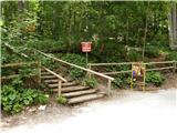 2
2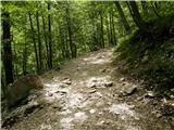 3
3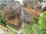 4
4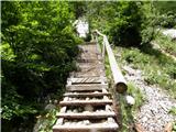 5
5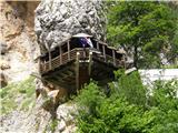 6
6 7
7 8
8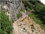 9
9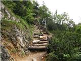 10
10 11
11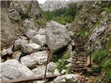 12
12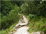 13
13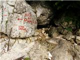 14
14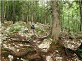 15
15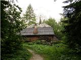 16
16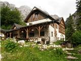 17
17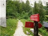 18
18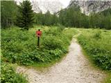 19
19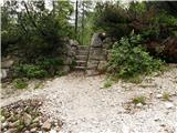 20
20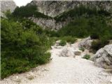 21
21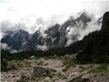 22
22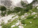 23
23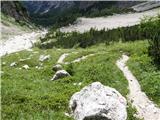 24
24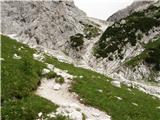 25
25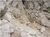 26
26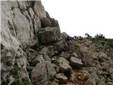 27
27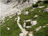 28
28 29
29 30
30 31
31 32
32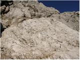 33
33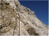 34
34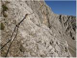 35
35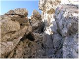 36
36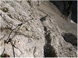 37
37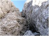 38
38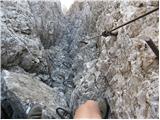 39
39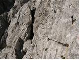 40
40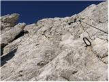 41
41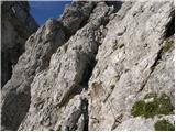 42
42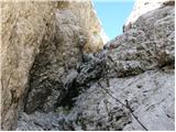 43
43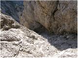 44
44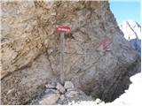 45
45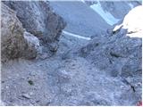 46
46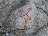 47
47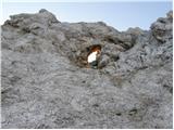 48
48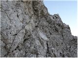 49
49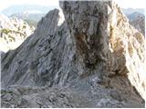 50
50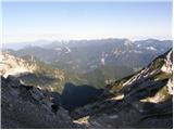 51
51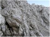 52
52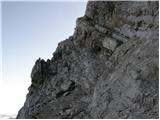 53
53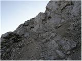 54
54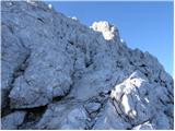 55
55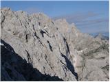 56
56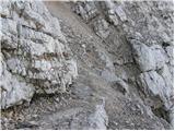 57
57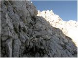 58
58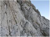 59
59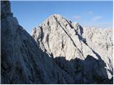 60
60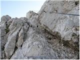 61
61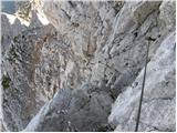 62
62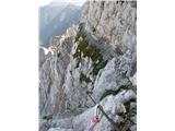 63
63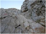 64
64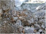 65
65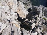 66
66 67
67
Discussion about the trip Koča pod slapom Rinka - Koroška Rinka
|
| aljoša123. 07. 2008 |
Good pictures, looks quite airy. We'll try this tour sometime in the near future from the Ledine and then on to Kranjska Rinka.
|
|
|
|
| aljoša121. 10. 2008 |
Can someone tell me how crumbly the path is from the window onwards to the top of Koroška Rinka?
|
|
|
|
| geppo21. 10. 2008 |
If the photo of the upper part of Koroška Rinka helps (page 3 ČEZ - KRIŽ - RINKE..) At that time the upper part was quite broken and crumbly - otherwise not. In normal annual conditions (like when I was there) it doesn't pose problems for an experienced hiker either. Now it's probably different..
Lp
|
|
|
|
| aljoša122. 10. 2008 |
Thanks for the information.
|
|
|
|
| mvrenc24. 10. 2008 |
Good day,
please for help. If I want to leave the car in Logarska dolina, after reaching the top of Kamniška Rinka, can I get to Frishauffov dom by some other way or do I have to return the same way? Namely, the next day I would like to go through Turski žleb to Brana, Kamniško sedlo and down to Frishauffov and to Logarska!
Thanks and greetings from Matulji.
|
|
|
|
| Tadej24. 10. 2008 |
There are two paths to Rinka from Okrešelj. The first is the one described above, the second goes through Turski žleb. So up the one described above and down through Turski žleb.
|
|
|
|
| mvrenc24. 10. 2008 |
Thanks Tadej and greetings!
|
|
|
|
| grahlck7. 11. 2008 |
Is this path harder than from Kotovo sedlo to Jalovec?
|
|
|
|
| grahlck7. 11. 2008 |
How far is it from Koroška Rinka to Kranjska Rinka? Thanks.
|
|
|
|
| Tadej8. 11. 2008 |
From Koroška Rinka to Kranjska Rinka it's about 15 minutes.
|
|
|
|
| aljoša123. 07. 2009 |
I'm interested in what this path is like for the return to the ledges?
|
|
|
|
| Preseren11. 08. 2010 |
Nice greetings,
on Sunday we plan this tour, one thing interests me, has anyone been near Turski žleb recently, what's the condition inside, is there any snow left? How about the descent via Turski, better on the ground, slowly and carefully, or via the cables?
P.
|
|
|
|
| geppo11. 08. 2010 |
The cables in the gully are in place and quite fun on the cables!!
Regards
|
|
|
|
| coooler21. 08. 2010 |
Isn't the info on the 22nd picture wrong?
|
|
|
|
| Sam.volk15. 08. 2011 |
Yesterday, 14.8.11 my wife and I did this tour. Start at Rinka waterfall, hut Okrešelj, cold valley. From there secured path to Koroška Rinka. Continuation Turska gora, kotliči, Kamniško sedlo, Okrešelj, Rinka waterfall. Wonderful tour, path without problems. Best.
|
|
|
|
| pasja_taca20. 08. 2012 |
Planning ascent to Koroška Rinka. I'm interested how long the ascent from the hut at Kokrsko sedlo to the summit takes. Greetings
|
|
|
|
| tina.cvetka23. 08. 2012 |
Sam.volk, how much time did you and your wife need for this tour?
LP
|
|
|
|
| MihaV23. 08. 2012 |
tina.cvetka, last month my friend and I did this tour, but only to Kamniško sedlo. It took us about 9 hours, relaxed pace and including snacks (3x) of course. We continued the next day towards Ojstrica. LP
|
|
|
|
| soncyka25. 09. 2013 |
Hi. Yesterday (24.9.13) I lost my adidas sunglasses - black, they were in a gray etui on top of Koroška Rinka (maybe Kranjska). Apparently they fell out of my backpack, I don't even know how. If found, the finder will have my great gratitude.
Regarding the hike, yesterday in the northern slope there was some snow to cross that wasn't sun-exposed. Since my colleague and I were first to the top, we had to break trail in places - footprints. On some slightly more exposed parts we had to be careful. Probably better now, as quite a few have passed yesterday.
About 15-20 min before the summit, a peg with cable was pulled out, which we hammered back with a stone, as otherwise it would be harder to pass (exposed part where you must hold the cable to step from one side to the other).
From Koroška Rinka to Kranjska there are some small snow patches on the path, but overall sunny and nothing impedes walking - safe.
|
|
|
|
| pajk28. 07. 2014 |
I'm interested how long approx. it takes from Rinka to Skuta. thanks
|
|
|
|
| funnyboy28. 07. 2014 |
Somewhere from 1h15 to 2h (depending on pace)
|
|
|
|
| stropci11. 08. 2015 |
I just want to warn that about 100m below the summit in the climbing section above the gully, a piton is pulled out and it's a bit unpleasant to cross for inexperienced hikers. Additionally, some rocks just below the summit are about to tumble into the valley.
For information.
Good luck!
|
|
|
|
| brele26. 09. 2016 |
Nice greetings
I'm wondering if the path also goes along that exposed ledge shown in picture 63?
|
|
|
|
| benja815126. 09. 2016 |
Yes, you can namely see the cable next to the ledge.
|
|
|
|
| sh26. 09. 2016 |
To me live it didn't seem so bad as it looks on the picture.
|
|
|
|
| jax26. 09. 2016 |
That ledge is beautiful, but it is interrupted at one spot and you need to pay a bit more attention. Last year the protections were damaged right there (a few comments above), so you had to pay more attention, but they've fixed the thing in the meantime, so there are no special difficulties despite that.
|
|
|
|
| redbull27. 09. 2016 |
Right after that ledge on the picture it used to be creepy,, now everything is a bit more renewed, no problem
|
|
|
|
| robotek17. 08. 2017 |
Did the descent on this path, personally not very pleasant for me - crumbly (helmet!) and some wire ropes are pulled out.
|
|
|
|
| J.P.25. 10. 2017 |
Trail done in August Koroška R. - Kranjska koča. From this direction there is no "at own risk" sign which is posted e.g. from the opposite direction. The route is not demanding but due to friability and several rocks that hold "only by the grace of God" it is more dangerous and requires extra care. Slowly and carefully. Lp
|
|
|
|
| Hribovc8229. 07. 2018 |
Yesterday's circular tour.
Logarska dolina, Koroška R.-Krajnska R.-Štajerska R. Mala R.-Turska gora.-Okrešel
https://youtu.be/cH083bx7aHE
P.s. The trail is without problems (protected), but caution is of course needed.
Regards
|
|
|
|
| Ansys22. 06. 2020 |
Today circular via Okrešelj towards Savinjsko sedlo and onwards to Rinke and back via Turški žleb. On the ascent there is quite a bit of snow on the path. The trail is passable otherwise, with some ingenuity you can manage without crampons (sometimes detour a few meters, somewhere you can even crawl under the snow) but caution is advised, as the snow fields are on quite exposed spots!!!
Descent is dry, only Turški žleb still has plenty of snow - pitons and cables protrude from the snow, just a few times you have to squeeze between snow and rock. Lp
|
|
|
|
| PlaRinka27. 08. 2020 |
Yesterday did this tour - on that exposed ledge the cable is renewed, so passage is no longer problematic. Great tour!
|
|
|
|
| Grive24. 06. 2021 16:49:43 |
Hello,
need to correct the description at the junction to Mrzlo gora (description under picture is for Mrzlo gora). There you go left not right (right is Mrzla gora).
Regards
|
|
|
|
| kalog14. 12. 2021 21:45:33 |
"soncyka 25.9.2013"
writes in her post that they hammered a piton with a stone?!?! Please don't do that! One relies on every piton seen in the wall and that is of course a mistake in your case! A similar mishap happened to me in Skuta, when I relied on a piton which pulled out with the sling! Imagine what it looks like when the body flies out of the wall holding the sling, not knowing what will happen.... Crazy feeling, especially when hitting the rocks and it takes minutes to realize what happened. Since that day I prefer to grip the rock which I test well by hand how it "holds". Hammering pitons with improper tools can be fatal for someone, for you....
Let this be a well-meant warning and better the piton hangs on the sling or is placed on the ground. Then we know exactly that where something should be (in the hole namely) there is nothing.
Greetings and wits in the head, path under feet, rocks in hands.
|
|
|
|
| Marx17. 06. 2024 21:48:25 |
How long does the demanding part last (from the entrance to the chains and pegs?
For comparison, I slightly underestimated the trail from Robanov kot through Jaruzale and needed more than an hour and a half to the pass under Žvižgavcem.
|
|
|
|
| zokipoki18. 06. 2024 06:04:53 |
The very demanding section from Mrzli dol to the overhang of the path on the Jezersko side is shorter, but more demanding than the one to the pass under Žvižgavcem. To the top of Rinka it's overall definitely longer and more demanding!
|
|
|
|
| Dvatisočakar16. 07. 2025 07:17:03 |
Yesterday I went from Okrešelj to Koroška Rinka (Križ), then to Kranjska Rinka and then via Turska gora and kotliči to Kamniško sedlo and back to Okrešelj. The hike was long but wonderful. I would like to praise the maintainers of the safety gear on Križ... really exemplary, so this part is pure pleasure. But I would urge the one who has already nicely renewed the markings somewhere to the kotliči (from the saddle), to do it to the end - to the top of Turska gora, because my colleague and I had quite some trouble descending to the kotliči due to very faded markings. Also the path from the top of Turski žleb to Rinka would need renewal of markings, the last ascent from this side to Koroška Rinka is anything but well-maintained (the path is really unpleasant and poorly marked.....the descent is especially problematic). I know that the terrain is difficult for making a nice path, nevertheless I think the situation is like this because it is poorly marked and then people climb each their own way and then you don't even know exactly where to go. If the markings are clearly visible, the path is trodden there and everything is clear. Anyway, so as not to just criticize (well-intentioned, of course), the Kamniško-Savinjske Alpe (although I'm from Gorenjska under the Karavanke) are the most beautiful and best maintained mountain range in our homeland - at least for me.
Good luck!
|
|
|
|
| docepe216. 07. 2025 08:03:33 |
The new markings were probably made as part of the arrangement of the Planjava - Brana path.
|
|
|
|
| Dvatisočakar16. 07. 2025 22:52:10 |
...probably true, because they end right around the kotliči...
|
|
|
To post a comment you must log in:
If you do not yet have a username, you must first
register.