Koča pod slapom Rinka - Dom na Okrešlju
Starting point: Koča pod slapom Rinka (1024 m)
| Latitude/Longitude: | 46,3696°N 14,5986°E |
| |
Walking time: 1 h 15 min
Difficulty: partly demanding marked way
Elevation gain: 372 m
Elevation difference along the route: 370 m
Map: Kamniške in Savinjske Alpe 1:50.000
Recommended equipment (summer): helmet
Recommended equipment (winter): helmet, ice axe, crampons
Views: 175.948
 | 9 people like this post |
Access to starting point:
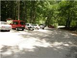
We drive to Luče (to here from Mozirje or over Kranjski rak) and continue towards Logarska dolina. Soon after the village Solčava we come to the junction, where the road to Logarska dolina branches off to the left. We turn left towards Logarska dolina (toll payment) and drive along the road to the parking lot at the Koča pod slapom Rinka mountain hut, where we park.
Route description:
From the parking lot, we go on a wide tourist path which starts gently ascending. After a good ten minutes of walking, we come out of the forest, where we come to a junction. We go left (right Orlovo gnezdo 3 minutes) in the direction of Dom na Okrešlju. The path ahead crosses a bridge and on the other side it starts ascending steeper. After a short ascent, the path brings us below the walls, from where a crossing to the top of the waterfall follows. This part is exposed to falling rocks. After that, the path crosses Savinja again and then ascends upwards along the river with the help of stairs. Next we ascend on the right side (left bank) of Savinja. Soon, we come to the source of Savinja, where we again cross the water. On the other side, the path goes into a dense forest and after a short ascent, it brings us to the winter shelter on Okrešlju. We continue left and in a few steps the path brings us to Dom na Okrešlju.

The trip can be extended to the following destinations: Matkov kot,
Kamniška koča na Kamniškem sedlu (1 h 30 min),
Bivak pod Mrzlim vrhom (1 h 45 min),
Ledinski vrh (2 h 15 min),
Vellacher Turm/Storžek (2 h 30 min),
Velika (Koroška) Baba (3 h 15 min),
Mrzla gora (3 h 15 min),
Turska gora,
Brana (2 h 30 min),
Mala Rinka (3 h 15 min),
Štajerska Rinka (3 h 30 min),
Planjava (3 h 30 min),
Koroška Rinka,
Kranjska Rinka
Photos:
 1
1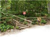 2
2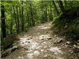 3
3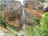 4
4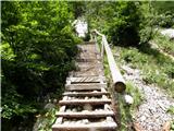 5
5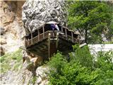 6
6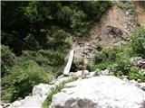 7
7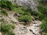 8
8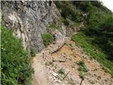 9
9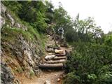 10
10 11
11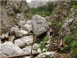 12
12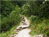 13
13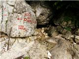 14
14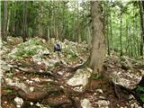 15
15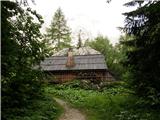 16
16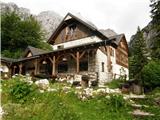 17
17
Discussion about the trip Koča pod slapom Rinka - Dom na Okrešlju
Show older messages
|
| Ivo18. 08. 2006 |
The path is, considering the catastrophe caused by avalanches in winter, very well maintained and marked.
All praise to PD Celje and the caretaker Jure and colleagues, who with great efforts arranged everything nicely.
Thanks to Jure for the pleasant company and hospitality.
|
|
|
|
| eurora17. 04. 2007 |
Nice greetings.
I'm interested in the path from Okrešelj to Kamniško sedlo, as it's not described here?
|
|
|
|
| andrej76714. 08. 2007 |
Fantastic - takes about 1.30 hours at moderate pace, the path is really beautiful among low pines, very pleasant all the way to the last wall where caution is needed although it's excellently secured. I'm not a fan of exposed paths myself but this is no problem, especially if going up from Okrešelj - descent is trickier because you have to grope a bit for foot holds. Highly recommended. 
|
|
|
|
| majdicst16. 08. 2007 |
The path to Okrešelj is really pleasant, especially if you start early enough to avoid crowds of inappropriately shod tourists.
Further to Kamniško sedlo yesterday (15 August 2007) it was about like on Triglav - endless processions of people, most of whom were going up. Whoever has the opportunity should consider crossing Kamniško sedlo and descending to Kamniška Bistrica - it's easier than returning to Okrešelj. You just need someone to drive you to Logarska Dolina and wait for you in Kamniška Bistrica...
|
|
|
|
| Gost17. 09. 2007 |
Exactly so, the path is wonderful, the view phenomenal, the environment and nature unrepeatable. Silence such that you hear the flutter of birds' wings... as long as no noise from some larger group of people disturbs it, who push forward like a bus.
The descent from Kamniško sedlo towards Okrešelj is really unpleasant, slippery terrain (loose stones ), and steep drop... especially if you meet someone on the path. Avoidance is of course possible, without problems,.... but great great caution is needed....
Nataša
|
|
|
|
| Gost17. 09. 2007 |
I recommend the path to Okrešelj also for beginners, as they will be rewarded with a beautiful view.
|
|
|
|
| Gost29. 10. 2007 |
I'm wondering how it would be to go to Okrešelj on Thursday if it's going to rain tomorrow. You know, the risk of slipping etc... I know I'm complicating a bit, but I'd rather go safely...
Oh, and one more thing... Until when is the hut open? Cheers!
|
|
|
|
| Gost29. 10. 2007 |
The path is mostly damp even when dry as it runs along the Savinja. The steep but easy sections are additionally secured with cable and steps. Just be careful on the descent, otherwise boldly go ahead.
|
|
|
|
| gad5. 01. 2008 |
At Okrešelj it's great, the manager and his team are very friendly, but can someone describe the path from Klemenčeva jama to Ojstrica via Kopinškova climbing path
|
|
|
|
| Gost6. 01. 2008 |
Description of the Kopinšek climbing route to Ojstrica can be found e.g. in the book "Kamniško-Savinjske Alpe" (Sidarta publishing) or in "50 insured climbing routes" of the same publisher. Advice on technical difficulty is very relative and personal. For me this route was in practice easier than described in the guidebooks, where it is defined as a very difficult marked route. You don't need a climbing harness in my opinion, but of course I recommend a helmet. The route is also physically demanding (approx. 1500 m elevation gain from Logarska Dolina) and requires respectful preparation and approach. I have no winter experience. So inform yourself well, take your time and good luck!
|
|
|
|
| geppo6. 01. 2008 |
I have hiked the route several times and it doesn't seem so demanding to me. In the upper part of the route there are some more exposed sections - but everything is well secured (wire ropes, pegs). In winter, it can be quite demanding! Once I went early in spring and without an ice axe I would have had trouble getting through - avalanches had covered the path and I had some crossings that required quite some knowledge and courage. Otherwise I hike the route: Mountain hut - Klemenča - summit of Ojstrica - return via Škarje - Mountain hut cca. 7 hours of good walking without long stops. And I agree that it is quite physically demanding!
|
|
|
|
| Gost6. 01. 2008 |
This spot on the forum is intended for (Discussion about the trip Koča pod slapom Rinka - Dom na Okrešlju) the discussion in brackets, not for what you write Gad, guest and geppo
|
|
|
|
| geppo7. 01. 2008 |
You are right - this page is for another topic!
Best regards
|
|
|
|
| antik26. 09. 2009 |
I'm interested in that other path from Logarska dolina to Dom na Okrešlju, before the Rinka waterfall, it goes somewhere to the right and I've never gone on it yet, but I've gone to Okrešelj very often already, I know that the other path goes somewhere to the right, it says shepherd's path or something like that on it, and it often said that this path is closed, I'm wondering if anyone knows if this path is open and if one can go on it... thanks
|
|
|
|
| Enka29. 09. 2009 |
Would a dog manage the path to Okrešelj?
|
|
|
|
| storžek29. 09. 2009 |
Antik, a month ago I went down this path, which had been closed for many years. From the kiosk you go directly up, first to the right, then left over two gullies above the waterfall. You reach the usual path just before the source of the Savinja. The path is a bit poorly marked, you need to consistently watch the markers, but it is longer than the direct one.
|
|
|
|
| storžek29. 09. 2009 |
Regarding dogs again. At the source, a dog and its owner were resting. They came via the shepherd's path and had quite some trouble over the gully where the path is partially collapsed.
|
|
|
|
| Enka30. 09. 2009 |
Storžek, thanks. I thought the dog would have to stay home this time.
|
|
|
|
| geppo1. 10. 2009 |
I think we misunderstood each other!!
Storžek was describing - the shepherd's path to Okrešelj, which is closed.
To Okrešelj one can go... just not afraid of walking on the bridge (above the waterfall there is a bridge over Savinja) and a few wooden steps!!!So cck. 15 m from the common path is more like it. If he's small you'll carry him.
Best
|
|
|
|
| Enka1. 10. 2009 |
Oh, thanks geppo, so those little bridges and ladders are only a few meters? Because then it would be doable, if not otherwise then by carrying, yes.
|
|
|
|
| Enka4. 10. 2009 |
Very nice panoramic path, steep of course, but not so demanding that a family wouldn't venture onto it. The dog stayed home, but now I can confirm that he would have managed the path .
|
|
|
|
| vespuci19. 11. 2009 |
21.11.09. I'm going from Okrešelj to Savinjsko sedlo and I'm interested in snow conditions.
|
|
|
|
| geppo20. 11. 2009 |
Check the post Okrešelj/Savinsko sedlo
if you need more info, write!
Lp
|
|
|
|
| rakec18. 07. 2010 |
Was on 17.7.2010 on this path, nicely maintained, tourists like rocks. But I met a family with a dog that went up smoothly, even on the stairs and bridge.
|
|
|
|
| teja.klobucar16. 08. 2010 |
On 8.8.2010 we headed to Okrešelj with two children (3 and 5 years old). Extremely nice and varied ascent, partly exposed too. What delighted us most along the path was the water (spring, waterfall).
|
|
|
|
| VanSims10. 07. 2011 |
On the way down from Okrešelj I took the shepherd's path.
Warning applies, there's a scree right at the start of the path or at the end if you're going up (if you can't cross it going down, just go a few dozen meters back to the normal path described above, going up you'd have to turn around right before the junction to the normal path because of it). This scree is namely hard to cross, and the protection with wire is completely bypassed. I walked like on eggshells, also so as not to trigger anything on those walking below.
Otherwise, it's a somewhat steeper path in the lower part and as someone already said up there, strict observation of marks is necessary.
|
|
|
|
| Dejan Golob31. 10. 2011 |
It really is a very beautiful and scenic trail!!
|
|
|
|
| Pohodnica5626. 11. 2011 |
Today I ventured into this little paradise. Although cold, icy in places, it's like a winter fairy tale around Solčava. Steep but beautiful trail. Surprised, the hut was open. True VanSims, markings are great. Icy in a few spots, but avoidable.
|
|
|
|
| grand30. 04. 2012 |
What are the conditions like on the path to the hut? From the highway KSA still looks quite snowy.
|
|
|
|
| balon13. 07. 2013 |
Hello!
I'm interested in how suitable this path is for children (4+6). Thanks and best regards.
|
|
|
|
| Becar13. 07. 2013 |
Personally, I wouldn't take a 4-year-old on such a trail. But if you must, tether him and equip him with proper footwear.
|
|
|
|
| sh13. 07. 2013 |
We walked this trail with children of similar age. Of course, proper footwear is the most important.
|
|
|
|
| petruša13. 07. 2013 |
We went on this trail with children aged 6 and 7 and continued further to Kamniško sedlo, which is much more dangerous than Okrešelj. So to Okrešelj there shouldn't be problems if he has stamina and of course good footwear. But we must watch our children anyway. Best regards and safe steps.
|
|
|
|
| VanSims13. 07. 2013 |
No, a four-year-old child I certainly wouldn't take on such a trail unless he is to mountains what Mozart was to music (playing piano at four). Six, seven years, yes that's already ok (probably not further to Kamniško sedlo, unless it's @primoza's child).
The Rinka-Okrešelj trail I would classify as partially demanding, and barely that. I don't know where the author got 'demanding' from.
|
|
|
|
| Keko13. 07. 2013 |
I would also agree that it is only partially demanding. But since this term isn't in the classification, it's quite right that it's rated as demanding, i.e. better a bit higher than lower, so that the difficulty doesn't surprise anyone. Especially families with small children, which you already meet quite a few on this trail.
|
|
|
|
| Becar14. 07. 2013 |
Keko, on hribi.net there is also the classification of partially demanding trail. Best regards 
|
|
|
|
| Keko14. 07. 2013 |
Yes, that classification really exists. I overlooked it because there are very few of them.
Then it could really be only partially demanding.
|
|
|
|
| dprapr14. 07. 2013 |
Precisely such trails are interesting for children and thus quickly draw them into the world of mountains. Of course, on exposed sections you need to hold their hand (passage above Rinka waterfall, ladders). The rest they manage without problems.
|
|
|
|
| balon26. 07. 2013 |
thanks to all for the answers
|
|
|
|
| balon26. 07. 2013 |
thanks to all for the answers
|
|
|
|
| pjoter5. 01. 2014 |
does anyone know if the hut at Okrešlju is open
thanks
|
|
|
|
| herman86. 01. 2014 |
Dom na Okrešlju is open in winter on Saturdays, Sundays and holidays, if the weather is nice. Call 041380177, that is the caretaker's mobile.
|
|
|
|
| slavkovoda6. 07. 2014 |
It is indeed a partially demanding path, especially after rain, but it offers exceptional views, interesting features along the way and a pleasant feeling in and around the hut.
|
|
|
|
| nadav15. 11. 2014 |
I'm curious about the current conditions for the path to Kamniško sedlo and whether it's possible to stay overnight somewhere there. Is there drinking water in the winter room?
|
|
|
|
| školjka19. 05. 2015 |
For the weekend I'd go from Logarska dolina to Okrešelj. Is the path already snow-free or no winter gear needed?
|
|
|
|
| zico1019. 05. 2015 |
the path to Okrešelj is no problem!
|
|
|
|
| zabava25. 07. 2015 |
Forecast was rather bad weather, but visiting Okrešelj was worth it. Weather held, the waterfall refreshed us a bit, lots of hikers, really pleasant day.
|
|
|
|
| Andrej Borko28. 12. 2015 |
I'm interested in the current condition of the trail to Okrešelj and further to Kamniško sedlo?
|
|
|
|
| mirni22. 05. 2016 |
Hi, I'm interested if anyone has been to Okrešelj in the last few days, what's the trail like, thanks
|
|
|
|
| garmont22. 05. 2016 |
Besides being steep, it is also dry.
|
|
|
|
| tinky22. 05. 2016 |
You really have to try hard to step into the snow. See current conditions Turska gora.
|
|
|
|
| garmont12. 09. 2016 |
The shepherd (hunter) path to Okrešelj is closed for the foreseeable future due to the consequences of a recent storm.
|
|
|
|
| mornar2. 12. 2016 |
Has anyone been to Okrešelj recently and is the hut open on weekends.
|
|
|
|
| crnistane8. 03. 2017 |
I'm curious what the trail to Okrešelj is like.....is it still snowy....
|
|
|
|
| garmont13. 03. 2017 |
Was up there today. Serious snow starts above the waterfall and there's still quite a bit. Track to the Hut is trodden. Regards
|
|
|
|
| crnistane8. 11. 2017 |
Is there any snow on the path to Okrešelj......
Thanks for the info.....
|
|
|
|
| garmont30. 09. 2018 |
The path has been newly marked since yesterday.
Previously, besides new fixed cables, the bridge at the waterfall was renovated and new wooden steps above it. Praise to the path markers.
|
|
|
|
| dingdong1025. 04. 2021 21:02:57 |
Yesterday I went to Okrešelj, the path is in poor condition.
The supports for the steel cables along the bridges are broken in several places, the bridge above the waterfall is displaced. There is a lot of snow around the waterfall, which is easy to cross. On the way back I had to turn around at the spring, where I didn't dare to cross the snow deposit without equipment.
|
|
|
|
| smatjaz26. 04. 2021 12:13:59 |
In the high mountains winter still reigns and the large amount of snow this season and avalanches have also caused enormous damage to the marked paths, so the markers are not yet doing their work and it will be necessary to wait a bit. Until then, be careful on the path and if there is not enough experience, better stay a bit lower.....
|
|
|
|
| ANDREJA1231. 06. 2024 23:54:24 |
Is the path to Okrešelj normally passable (floods or storm August 2024?)?
|
|
|
|
| garmont2. 06. 2024 20:04:00 |
No problems.
|
|
|
|
| milepetro3. 06. 2024 10:32:15 |
What is the current condition like over Turski žleb and below it, I mean Savinjsko sedlo and further? Has anyone been there over the weekend?
|
|
|
|
| ovi27. 09. 2024 17:45:56 |
AfnaAndreja123 the trail is newly marked-with a detour to the right up above the source of Savinja - great tour - for Turski žleb I don't know (was with dog);Crowded (on Sunday, 22.9.2024 - but without problems) - the guys really made an effort after the recent storms - hats off...Moderators - and you, have you taken the brush in hand, without pay? ?And safe steps..RRokaj...Rokaj.
|
|
|
|
| Tajka6730. 04. 2025 17:53:48 |
Super marked, safe, wonderful weather and no crowds. The new hut stands empty, unfinished. No snow to the monument for deceased hikers, further towards Savinjsko sedlo snow.
|
|
|
|
| tomo_kugy30. 04. 2025 23:08:51 |
@ovi, @Tajka67
Thanks for the nice words about the marking. Last year was really an unlucky year for this path. The markers of PD Celje-Matica with the help of volunteers from other PDs and GRS repaired the consequences of weather disasters twice last year. This winter additional damages and landslides occurred, mainly at the source of the Savinja. We are aware that the current solution is not the most optimal, but that's what the mountaineering club's markers can ensure. Certainly a complete rehabilitation of the entire path will be needed, for which the assistance of the PZS technical team will be required.
|
|
|
To post a comment you must log in:
If you do not yet have a username, you must first
register.