Koča pod Košuto - Koschutnikturm (Košutnikov turn) (via Cjajnik / Lärchenturm)
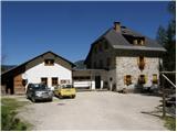
Starting point: Koča pod Košuto (1280 m)
| Latitude/Longitude: | 46,4517°N 14,3875°E |
| |
Route name: via Cjajnik / Lärchenturm
Walking time: 4 h 30 min
Difficulty: extremely difficult marked way
Via ferrata: D
Elevation gain: 853 m
Elevation difference along the route: 1050 m
Map: Karavanke - osrednji del 1:50.000
Recommended equipment (summer): helmet, self belay set
Recommended equipment (winter): helmet, self belay set, ice axe, crampons
Views: 99.944
 | 10 people like this post |
Access to starting point:
Over the border crossing Ljubelj we drive to Borovlje / Ferlach, where we turn right in the direction of the village Sele / Zell-Pharre. A little before the sign which marks the settlement Sele / Zell-Pharre, a road branches off to the right towards the mountain hut Koča pod Košuto / Koschutahaus. We follow this road all the way to the mountain hut, where we park on a large parking lot.
Route description:
From the parking lot, we head southeast following the signs Lärchenturm / Cjajnik, Koschutnikturm / Košutnikov turn. At the beginning of the path, we will also notice a large board with a picture of Košuta and accurately drawn paths to Cjajnik and Košutnikov turn. The path then runs through the forest towards the east for some time and brings us to a junction where we turn right following the signs Cjajnik. We soon come out of the forest to a scree field which we then cross in ascent towards the west (in the direction towards Cjajnik). When crossing the scree, we follow the red-white blazes; the large yellow blazes on the rocks should not confuse us, as they lead upwards on the scree towards the gully which leads towards Cjajnikova škrbina.
At the entrance to the climbing section of the path, we must equip ourselves with a helmet and a self-belay set; the use of climbing gloves is also highly recommended. The path already at the beginning ascends steeply and then crosses a steep wall to the right. The path is secured throughout with a steel cable, and occasionally some pegs assist us, but far fewer than one might expect. There are not many footholds, and much of the work during the ascent must be done with the hands. The path then proceeds slightly to the right for quite some time and ascends almost vertically several times. Later, the path turns left and ascends a somewhat easier, slightly vegetated slope. For a short time, the summit of Cjajnik also appears to us, then we re-enter the wall. We ascend very steeply again, and the exposure becomes greater. The steepness rarely eases further on, then the path turns slightly right and brings us to a junction below the summit tower. We have two paths to choose from that lead to the summit; regardless of which one we choose, very demanding climbing awaits us. The left path is marked with difficulty level D, the right with difficulty level C.
Austrians rate the difficulty of climbing paths with grades from A to E, where A is the easiest and E the most difficult.
The right, easier path first bypasses the summit on the right side, then ascends to the summit from the west side. The left path ascends vertically from the junction towards the summit. The climbing here is really very demanding as there are not many holds in the rock. Only a few pegs and the vertical steel cable assist us.
From the summit, we then descend a somewhat easier but still extremely demanding path of difficulty level C. First, we must step over the narrow notch from the northern tower with the aid of the steel cable, then we begin descending the almost vertical wall. Soon we reach a junction of paths in the western wall of Cjajnik. We head left towards Cjajnikova škrbina (Lärchenscharte); right leads the path towards Koča pod Košuto. From the junction, we then cross slightly towards the south; the steepness does not ease until Cjajnikova škrbina. When we step onto firm ground in the notch, we can breathe a little easier as the worst is behind us. In the notch, we will also notice old blazes which from the notch lead down the eastern gully into the valley. This path is not suitable for descent as it is closed due to great crumbliness.
From the notch, we continue along the trail which first leads southwest, then begins to ascend steeply on steep grass towards Užnik. A slightly crumbly ascent in a narrow gully follows, and we soon reach the main ridge of Košuta.
On the ridge, we turn left and continue along the south side of the ridge. The path initially runs along relatively steep grassy slopes; later, when we return to the ridge, the path becomes somewhat exposed, and some steel cables assist us. From the left side, the climbing path to Košutnikov turn from the Austrian side (ÖTK Steig Neu) then joins us; a few meters later, the western path from Planina spodnja Dolga njiva joins from the right side. We continue along the south side of the ridge and, on the path which becomes somewhat steeper, soon reach the panoramic summit.
The described path is extremely demanding, especially the ascent to Cjajnik and the descent to Cjajnikova škrbina. This section of the path is suitable only for the most experienced mountaineers with sufficient arm strength and mandatory self-belaying. The path to Cjajnik is among the most difficult in the Karawanks and harder than most Italian extremely demanding paths in the Julian Alps.
We can descend along the climbing path to Košutnikov turn (ÖTK Steig Neu).

Photos:
 1
1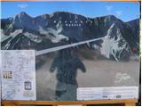 2
2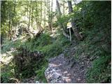 3
3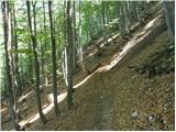 4
4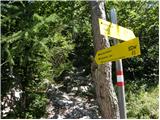 5
5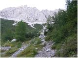 6
6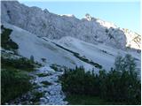 7
7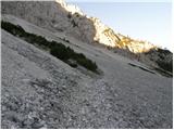 8
8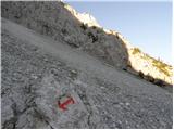 9
9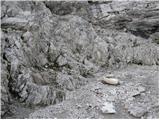 10
10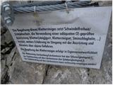 11
11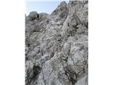 12
12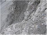 13
13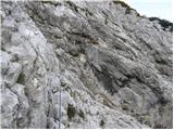 14
14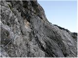 15
15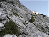 16
16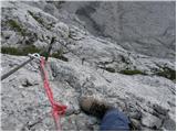 17
17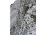 18
18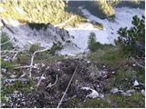 19
19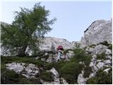 20
20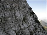 21
21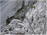 22
22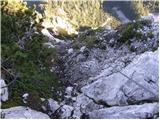 23
23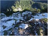 24
24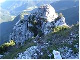 25
25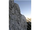 26
26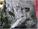 27
27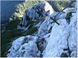 28
28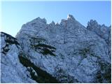 29
29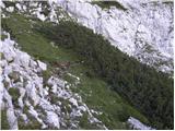 30
30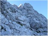 31
31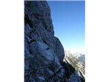 32
32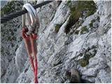 33
33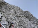 34
34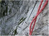 35
35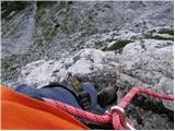 36
36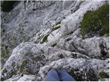 37
37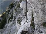 38
38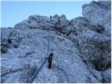 39
39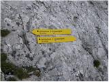 40
40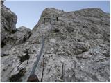 41
41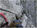 42
42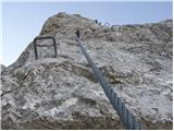 43
43 44
44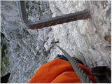 45
45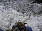 46
46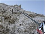 47
47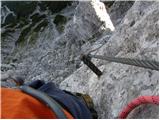 48
48 49
49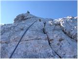 50
50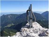 51
51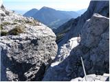 52
52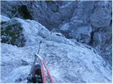 53
53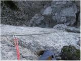 54
54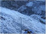 55
55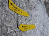 56
56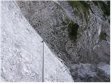 57
57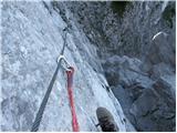 58
58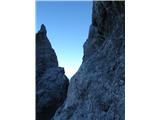 59
59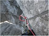 60
60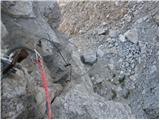 61
61 62
62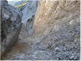 63
63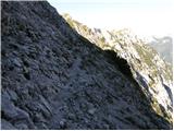 64
64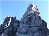 65
65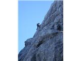 66
66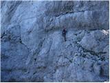 67
67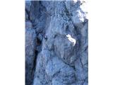 68
68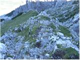 69
69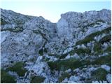 70
70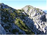 71
71 72
72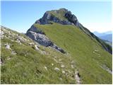 73
73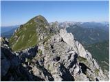 74
74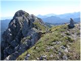 75
75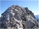 76
76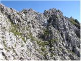 77
77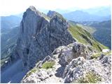 78
78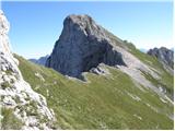 79
79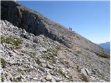 80
80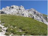 81
81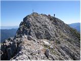 82
82
Discussion about the trip Koča pod Košuto - Koschutnikturm (Košutnikov turn) (via Cjajnik / Lärchenturm)
Show older messages
|
| aljoša121. 08. 2008 |
This one is extreme and probably very adrenaline-pumping. I can't imagine myself on this path, even though I've already done some and will do more.
|
|
|
|
| frfi22. 08. 2008 |
Hiked with a friend 14 days ago and I have to say it's a pretty tough via ferrata with beautiful views towards Austria, but once on the ridge, the view is even better 
We did the same tour in 5-6 hours with all stops.
|
|
|
|
| jprim27. 08. 2008 |
I'm asking a purely simple question about self-belaying, of course I don't mean on such paths, but I'm interested in how it is that both karabiners are attached to the cable, since I read in one guidebook that only one should be, then the other to the next cable and so on. Please explain and thanks for the answer.
LP
|
|
|
|
| nekdo127. 08. 2008 |
Safer with two than one... then you unclip from the first and clip into the next section and repeat the process with the second karabiner 
|
|
|
|
| ben27. 08. 2008 |
If you use a Y self-belaying kit, you clip in with two karabiners, for safety reasons, as you are always secured even when switching. The brake slider in this system works even when attached with both karabiners, unlike the V system where the brake doesn't work, so you're attached with two only when switching, otherwise just one.
LP
|
|
|
|
| Bojan_A27. 06. 2010 |
Oh, I know you can't read. So: I ascended the via ferrata to Cjajnik, descended the via ferrata to Košutnikov turn. It was great. Just on the descent to Cjajnikovo škrbino you need some caution and arm strength.
|
|
|
|
| bagi5. 07. 2010 |
Two warnings are in place this summer season for the ascent to Cjajnik besides all the already known ones regarding the difficulty of the ascent.
The first is that the descent from the saddle after descending from the tower via the eastern gully is currently not possible with summer gear. There is still almost 100m long snowfield here, too steep for a successful descent and undercut at the edges by warm rocks. There is also constantly present danger of falling rocks. This shortcut is discouraged even in dry conditions, now even more so. The trail must be continued over the ridge of Košuta.
The second warning is early approach in summer months. Already at 5.30 on Saturday the sun showed its power during the ascent through the scree to the via ferrata entrance. The trail is mostly very bad and scree + heat is not the best combination  . Of course, upon entering the wall the heart starts pounding and efforts are immediately forgotten , but the warning is in place. . Of course, upon entering the wall the heart starts pounding and efforts are immediately forgotten , but the warning is in place.
Both via ferratas, namely the ascent to Cjajnik and the descent via ÖTK Steig Neu from the saddle before Košutnikov turn are full-blooded and demand their toll. Both are exemplary maintained, the suspension bridge is also fully equipped for crossing and descent on the adjacent hill where steel cables are tensioned throughout. Lots of enjoyment .
Bagi
|
|
|
|
| mikk30. 07. 2010 |
I'm interested in how much experience is needed for such a feat?
I have very little experience regarding climbing. After 15 years from the last hike (not climbing) in the mountains, I ventured into the hills and went first via Tominškova path to Triglav, and the path didn't seem overly difficult to me... That's why I'm looking for bigger challenges... If you have other suggestions, please suggest those too :-)
|
|
|
|
| AndrejK30. 07. 2010 |
I've tried most climbing tours in the Slovenian mountains and I can tell you that the tour to Cjajnik is at the top of that list. It really deserves to be called an "exceptionally" demanding tour, as stated in the route description. Self-belaying and helmet are mandatory, and arm strength is especially important, as it carries the main burden throughout the entire tour. Check out some photos: http://andrejk.moj-album.com/album/17205011/?stran=1
|
|
|
|
| bagi30. 07. 2010 |
Mikk. I don't know your experience and abilities. If Tominškova is the only one of this kind, it's better to try the neighboring via ferrata ÖTK Steig Neu to Košutnikov turn. It's one grade easier, but still not for everyone. Even better, borrow the excellent book "50 Zavarovanih poti" by Andrej Mašera from the library. It has routes categorized by difficulty with all descriptions. There you can rank yourself by categories and choose suitable routes. With mileage, Cjajnik will come too. Don't worry, it won't run away. I wish you a good choice and above all enjoyment on the via ferratas.
LP Bagi
|
|
|
|
| geppo30. 07. 2010 |
Just as these guys already said. In Slovenia, there is no such secured route that is so demanding. Drive to Austria and climb the via ferrata to Košutnikov turn (cck. 30min). If you go up and down without fear and problems, then know that Cjajnik awaits you with at least two hours of roughly similar terrain and a bit harder. That's how you can assess yourself.
LP
http://www.hribi.net/trenutnerazmere.asp?aut=1&gorovjeid=11&id=1222
|
|
|
|
| SilvestrO30. 07. 2010 |
geppo,... well, I hope we won't have such secured routes here either..., too forced...
A few weeks ago, when I went to check out this wonder,...and caught up with the trembling scared girls in the wall, nothing to say the view upwards was fascinating and I really enjoyed it doubly,...for them I wouldn't say,...until I overtook them on natural passages...too bad
Lesson ...not for everyone...
|
|
|
|
| geppo30. 07. 2010 |
I also think that no one here will think of something like that. Across the border, we have as many ferratas as you want.
But I have nothing against what I recently visited in Lawamünd, which is good for training and learning via ferrata climbing.
http://www.hribi.net/trenutnerazmere.asp?aut=1&gorovjeid=10005&id=2661
Here you can nicely teach someone (or yourself) how to use the self-belaying kit, harness, etc.
LP
|
|
|
|
| mikk30. 07. 2010 |
Wow, how much you've written. THANKS to everyone :-)
@geppo - this Lavamünd is from Dravograd across to the AT side ?? If yes, then I'll be there on Sunday.. hehe :-)
|
|
|
|
| geppo30. 07. 2010 |
Exactly!
After crossing the railway track, you'll see the parking lot on the right and that abandoned quarry with the church on top. You can't miss it.
I'm waiting to hear what you'll say...? They say, if you climb up and down this ferrata without using the pegs, you're ready for something more serious. Well, I used a peg, which you'll probably do too!!
Check it out in the photo..
LP
|
|
|
|
| dedo246. 07. 2011 |
Has anyone gone on this trail this year or recently? How is it regarding snow?
LP
|
|
|
|
| Marin1. 08. 2011 |
Yesterday we climbed to Cjajnik. The tower without using pegs is very demanding, as is the descent from the top. The path to Košutnikov turn is much easier, nice view on Slo. and Aus. side. Descent via ÖTK Steig Neu becomes more interesting, crossing the bridge pumps some adrenaline through the veins. Excellent combination (ferrata and hiking). Recommend to all fans of C/D difficulty ferratas.
Best
|
|
|
|
| elektro25. 09. 2011 |
We tackled this ferrata last week. First ferrata of such difficulty for me; plenty of adrenaline and it also provides good training for the whole body.
There was apparently quite some controversy around this ferrata and in the end I myself wondered where the sense of this path is. Otherwise it doesn't bother me and probably there are people who suit such paths; but to me it seems somehow forced and without feeling. Using all limbs is desirable and that's why I also visit ferratas, but literally dragging myself along the cables for a good part of the path because there are no natural holds is just nonsense to me.
|
|
|
|
| urbancek25. 09. 2011 |
Yes, that's the Austrians who crave only difficulty... That's why they're so fast on "easier" ferratas, because they train non-stop in these naturally vertical gyms
|
|
|
|
| elektro27. 09. 2011 |
Speed doesn't matter to me, everyone walks at their own pace.
I just don't know what you can get used to on such a via ferrata except remembering to bring gloves to prevent blisters...
probably such via ferratas are training grounds for those we meet in our mountains who just pull on the cables and practically ignore natural holds.
The real training ground is the path over Plemenice - few cables and some more pegs; metal is used where it's really needed, otherwise not, and you have to use the natural features of the via ferrata.
|
|
|
|
| urbancek27. 09. 2011 |
@elektro: Austrians "train" on super demanding via ferratas, to which Cjajnik, let alone Plemenice (I don't know what's so demanding there ) don't come up to their knees... ) don't come up to their knees...
Best regards!
|
|
|
|
| elektro28. 09. 2011 |
I believe it's fine for them. But can we even easily call this climbing? Pulling on cables and stepping on brackets (like walking on a greased ladder) is not climbing for me.
Plemenice are not difficult, but a real training ground where you get used to using natural holds and walking on airy ferratas. If I compare Plemenice and this over Cjajnik, it was much more varied on Plemenice, because you're much more dependent on yourself and really can't afford mistakes. Over Cjajnik you're always tied to the cable anyway, and even if you slip it's not such a problem - you slide down a bit (literally hehe) but at least you have a second chance.
I feel safer in a real rally car at 250km/h (with roll cage and five-point harness) than say in some Clio at 150km/h...admittedly bad comparison but I hope you see what I'm aiming at.
|
|
|
|
| urbancek28. 09. 2011 |
But if I compare Plemenice and Cjajnik, Plemenice were much longer, Cjajnik not... And Plemenice aren't a ferrata... Second chance on Cjajnik, on the summit pillar? Have you even been up there?? If you fly those two meters there, you break your spine immediately
Regarding natural holds... e.g.: Mrzla gora, from Vevnica towards Strug and further etc., those are natural holds, not Plemenice, where after the initial secured part, you hardly use your hands until the next secured part...
I really don't know where you walked this and if at all...
|
|
|
|
| Kita20. 03. 2012 |
Cjajnik is a respectable and quite demanding via ferrata...
|
|
|
|
| Poprck2. 05. 2012 |
Cjajnik is like every other via ferrata of this difficulty level "forced" and deliberately does not use natural passages, where the emphasis is on gymnastics along the cable rather than the natural beauty of the path itself. Plemenice are certainly a more naturally executed tour, which mostly uses existing natural passages, each of these two has its own charm and also pros and cons. But just as a romantic will not overly admire and enjoy via ferratas where the emphasis is on exercise, the adrenaline junkie will also get bored on naturally routed paths, there are two different types.
I haven't seen any tests anywhere on how quickdraws perform in a harder fall in such a via ferrata, because the fact is that in this case they break transversely on the bolt and in Govžnarjevi peči they already solved this with rubber attachments, while I haven't seen these in Austrian via ferratas yet.
I also wonder why in these more difficult via ferratas they still stick to classic cable and pegs, it would seem much more interesting to me if at certain passages one had to use aids for classic technical climbing, and the cable would perhaps only serve as protection, but then it probably wouldn't be accessible to a wider audience anymore.
LGP
|
|
|
|
| acjom4. 07. 2012 |
Is the mentioned trail more demanding than Božičev vrh in Železna kapla? Thanks
|
|
|
|
| pohodni4. 07. 2012 |
From a technical point of view, the climbing path via Cjajnik is indeed slightly easier than the one in Železna kapla, but before setting out on this path, we must consider a few more facts.
In Železna kapla, we only ascend the climbing section, practically everyone returns downhill via the easy circular path. On Cjajnik, there is no such option. Either return via the same climbing path or continue towards Cjajnikova škrbina, where a very difficult descent also awaits us. Of course, the mentioned path is not yet finished, as a quite demanding descent from Košutnikov turn awaits us, either via the suspension bridge or bypassing it.
If I were to sum it all up somehow, I would say that at least in my opinion, the path via Cjajnik is considerably more demanding in terms of fitness, overall via Košutnikov turn also more strenuous and longer, and in technical terms, precisely because of the obligatory difficult descents, not much easier than the one in Železna kapla.
Best regards.
|
|
|
|
| acjom4. 07. 2012 |
Thanks, when I return I'll share my impressions too.
|
|
|
|
| Tinch2. 08. 2012 |
Yesterday I was on the mentioned tour. On the path to Cjajnik there's still a warning that the path is closed, but in the hut they confirmed it was reopened on 31.7.
|
|
|
|
| pravi2. 08. 2012 |
The avalanche went 200m away from the path, so no problems with access, probably the warning is so that you hike at your own risk..
|
|
|
|
| urbancek3. 08. 2012 |
This wasn't clear to me either. The rockfall and its impact zone in my opinion don't reach the path to Cjajnik at all
|
|
|
|
| ljubitelj gora25. 10. 2012 |
Yesterday I took this path, the landslide that happened in summer was quite a bit to the left of the entrance to the ferrata at Cjajnik, path open, but there are various warnings for via ferrata sets, returned via the suspension bridge which was swaying quite a bit, a bit scary, and I had no one with me to say some encouraging words
|
|
|
|
| jure197725. 10. 2012 |
I did the trail with a group on Sunday. Fantastic weather, the path is excellently secured and definitely worth seeing. The bridge swayed quite a bit for me too . The first three steps are the most "fun", then it goes smoothly onwards.
|
|
|
|
| bohornik16. 11. 2012 |
I'm looking for information on the current conditions on the above-mentioned ascent. Thanks!
|
|
|
|
| ljubitelj gora16. 11. 2012 |
question about the fixed protections due to ivy, because last time at the beginning I had a bit of smooth cable.
|
|
|
|
| ms_primoz24. 07. 2013 |
Is anyone going to hike the mentioned path soon? How are the fixed protections? Good luck and safe steps
|
|
|
|
| acjom24. 07. 2013 |
Path hiked fourteen days ago, no peculiarities. Just boldly to the top, good luck and safe
|
|
|
|
| MaxSi24. 09. 2013 |
The last summer day was perfect for mountaineering and since I fancied some adrenaline, I decided to repeat Cjajnik.
Despite some complaining that you drive too high by car, the Koča pod Košuto is at 1300m, it didn't bother me at all, as Cjajnik is really good "workout".
Surprisingly, despite the ideal day, there wasn't excessive traffic, only about 15 hikers I met.
To not ramble too much, here's some comments, as the path is truly impressive.
The warm-up part on scree to the base of the wall warms us up well and right after entry, you need to tense muscles considerably. Protections and cables are in excellent condition, only on some section a loose cable surprises, but it poses no danger, just pay more attention to step and grip. The middle part is in my opinion overly protected, but better more than less, especially for the unaccustomed. The final tower offers real adventure and no doubt we sweat honestly. On the tower, the thought haunted me how skillful and brave those are who tackle the free ascent, I myself didn't let go of the cable for a moment.
Surprisingly, the descent from the tower due to smooth rocks and already tired arms is quite challenging, almost I could say I ascended easier than later descended.
Of course it's a shame to descend back to the valley, so continuation to Košutnikov turn and return via ferrata ÖTK Steig Neu is almost obligatory.
On this part I'd like to warn about crumbly rock and falling stones! Follows adrenaline thrill on the wobbly bridge and descent to scree...
Wonderful tour, with exceptional views and variety. Mandatory good fitness and equipment. Those with vertigo better avoid it
|
|
|
|
| Pero#2424. 10. 2013 |
Hello,
I'm interested in where the most suitable descent is if you go down this path.
Thanks, lpp
|
|
|
|
| jax25. 10. 2013 |
The most natural is via the via ferrata from Košutnikov turn. You can also go down the eastern gully, but it's apparently quite dangerous due to rocks.
The only somewhat more normal descent is along the marked path around Tolsta Košuta, which is a damn big detour.
|
|
|
|
| neyo25. 08. 2015 |
I have a question. If I go to Košutnikov Turn from the Dolge Njive pasture, how far is it still to the high bridge. I would just like to go over the high bridge and then back to Dolge Njive. I'm interested in the time for the complete tour. I would go tomorrow. I hope the weather holds.
|
|
|
|
| ms_primoz25. 08. 2015 |
From the top of Košutnikov Turn to the bridge is about 20 min... but without self-belay gear I don't recommend it to you.
|
|
|
|
| neyo25. 08. 2015 |
Thanks for the reply. I have the self-belay kit. Best regards
|
|
|
|
| mukica4. 08. 2017 |
Yesterday's climbed path to Cjajnik and continuation to Košutnikov Turn started in quite a fresh morning, on the scree it was already quite hot, but in the wall it was honestly hot for me. Path without peculiarities, as written...requires some strength in arms, climbing skills and knowledge of using protections...Happy that my wish came true and I will be glad if I return again
|
|
|
|
| ŠpRo294. 08. 2017 |
Bravo, congratulations. Also my wish. Can I ask, is the path to Košutnikov Turn well marked? What about descent from Cjajnik, it looks quite vertical in the picture.
How much time difference is there between path C and D?
Thanks in advance.
|
|
|
|
| mukica4. 08. 2017 |
Yes, the path ahead is marked, albeit with faded red markers, but the trail is very well visible... no problem. The descent is as it looks, vertical... I won't repeat the difference between C and D, probably just a few minutes, because part of the descent is then on C... and then it redirects towards the marked path to Košutnikov Turn.
|
|
|
|
| ŠpRo294. 08. 2017 |
Thanks, how much time from Cjajnik to Košutnikov Turn?
|
|
|
|
| ŠpRo296. 08. 2017 |
Yesterday I did this tour and yes, I also liked it very much and it left enthusiasm. The fixed protections in excellent condition, strength in hands and also in legs very welcome.
|
|
|
|
| Grega9228. 05. 2018 |
Hi
Has anyone been through the via ferrata recently, is there still any snow?
|
|
|
|
| peterr28. 05. 2018 |
Yesterday I saw on FB (Gorski svedri) that the via ferrata is closed due to damage. Check
|
|
|
|
| zlatorogus19. 07. 2018 |
Hello! Does anyone have info if the via ferrata is already open?
|
|
|
|
| zlatorogus19. 07. 2018 |
Thanks for the link. I called and the guy says the via ferrata is open. zuppa gut!
|
|
|
|
| janezs7320. 07. 2018 |
This week after work: from Koča pod Košuto to Cjajnik, over the notch to the main ridge, to Košutnikov Turn and down via OTK. All paths are passable, no snow anywhere, some fixed ropes might be looser, but nothing problematic.
|
|
|
|
| Turbolazec12. 06. 2020 |
Hi! Does anyone know what the conditions are like? Is there still some snow or is the path normally passable?
|
|
|
|
| jax12. 06. 2020 |
Completely passable. Some snow might be only on the descent via the variant that avoids the bridge. Therefore I recommend descent via the bridge.
|
|
|
|
| Turbolazec12. 06. 2020 |
Thanks, the plan is also to descend via the bridge.
|
|
|
|
| fjr23. 07. 2021 06:29:01 |
Nice regards. I'm asking if the path is already passable without winter gear. Thanks.
|
|
|
|
| Lukito23. 07. 2021 15:04:51 |
On Wednesday they climbed both Cjajnik and Košutnikov turn, on the Slovenian side there's no snow anywhere, I don't know about the Austrian side, but I didn't see them carrying winter gear. Good luck.
|
|
|
To post a comment you must log in:
If you do not yet have a username, you must first
register.