Klemenčevo - Korošak Waterfalls
Starting point: Klemenčevo (600 m)
| Latitude/Longitude: | 46,2739°N 14,5709°E |
| |
Walking time: 45 min
Difficulty: easy unmarked way
Elevation gain: 200 m
Elevation difference along the route: 200 m
Map: Kamniške in Savinjske Alpe 1:50.000
Recommended equipment (summer): helmet
Recommended equipment (winter): helmet, ice axe, crampons
Views: 27.083
 | 5 people like this post |
Access to starting point:
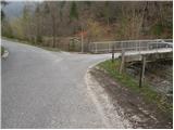
From Kamnik we drive towards Stahovica. Immediately after the village Godič we turn left onto the road in the direction of Županje njive. At the next intersection, we go left in the direction of Bistričica and we follow the road to the village Klemenčevo, where we turn right over a small bridge and then we park on a smaller parking lot. In front of the bridge are signposts for Kamniški vrh and mountain pasture Osredek.
Route description:
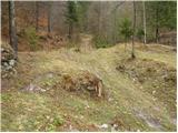
From the parking lot, we continue on the main road which gently ascends on the left side of the stream (right bank). After a few minutes' walk, the path brings us to a bus turning point, after which we notice the signposts for Ambrož pod Krvavcem. Only a little further the road brings us to a smaller crossroad, where we continue right over a bridge. After the bridge, we get to houses, at which we leave the marked path towards Krvavec. We continue right on a cart track which ascends through a meadow. The cart track, which becomes worse the higher up it goes, leads us between two hayracks and then brings us to a smaller confluence at the ruins of an old house. The path ahead leads us on the right side of the ruins and then over a wire fence brings us to a stream by which we then ascend. The path which further runs by the stream crosses it several times. At the spot where the path withdraws from the gorge to the right we notice the 1st waterfall to which we have only a minute of walking along the stream bed. At a low water level, it doesn't deserve the name 1st waterfall.
The path which withdraws from the gorge to the right brings us, after a short ascent, to the next waterfall, which in dry periods entirely dries up. The path which further ascends more steeply quickly brings us to a smaller saddle, where we come to the next junction. To the left first slightly downwards, then upwards a path branches off towards the next waterfall. After five minutes of walking we get to the lower one in the main chain of waterfalls. If we want to reach the upper largest one we have to ascend on the left side of the waterfall steeply upwards (it isn't appropriate for less experienced).

Photos:
 1
1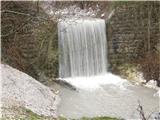 2
2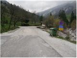 3
3 4
4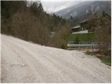 5
5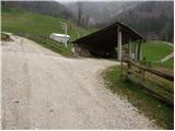 6
6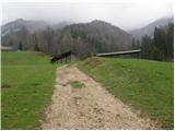 7
78
 9
9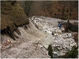 10
10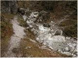 11
11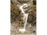 12
12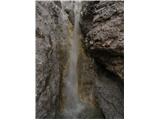 13
13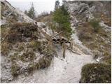 14
14 15
15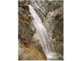 16
16
Discussion about the trip Klemenčevo - Korošak Waterfalls
|
| Kokta26. 05. 2012 |
Yes, unmarked path..listen to the sound of the stream and follow it 
|
|
|
|
| velkavrh24. 04. 2013 |
This afternoon I went for a pleasant walk to the gorge of the Koroški Waterfalls. Now there is enough water and the waterfalls are beautiful. Already soon at the beginning we have to turn a bit to the left to the first waterfalls, which are like some kind of basins - nice. I went to the lower Koroški Waterfall, which is really magnificent at this time. Last autumn I went further, but there was very little water.
|
|
|
|
| Ljubljana1. 08. 2015 |
We visited the waterfalls. Only the waterfalls deserve a visit. Everything else about the path is open to criticism: first the path description - completely misleading and incorrect. Somewhere we maybe saw 1 to 2 markers.
Whoever maintains the path and access to the waterfalls doesn't want any visitors, so we won't come back either.
I advise against the trip especially for families with small children.
Best regards.
|
|
|
|
| garmont1. 08. 2015 |
In the trail description, which by the way is completely accurate, it states that this is an easy unmarked path, so it is "maintained" accordingly. There is no official caretaker for unmarked trails, so everything is more or less left to individuals who carry a saw in their backpack among other things...
Best regards
|
|
|
|
| gams442. 08. 2015 |
no one needs you, who asked you anyway

|
|
|
|
| lino2. 08. 2015 |
gams44 - very short and direct answer.
|
|
|
|
| Zamimi12. 02. 2021 |
Today, 12.2.2021 there was snow on the path and also an icy trail, without crampons and poles the path would really be difficult. A friendly local warned us that heavy rain washed away a landslide above the waterfalls and that we should be careful, because some "material" is still left and it could collapse again. We reached the waterfalls, the water was brown from the soil, but we didn't go right to the bottom, because it seemed dangerous.
Happy hiking!
|
|
|
To post a comment you must log in:
If you do not yet have a username, you must first
register.