Jermanca - Planjava (via Kamniško sedlo)
Starting point: Jermanca (900 m)
| Latitude/Longitude: | 46,3349°N 14,5848°E |
| |
Route name: via Kamniško sedlo
Walking time: 4 h 30 min
Difficulty: difficult marked way
Elevation gain: 1492 m
Elevation difference along the route: 1492 m
Map: Kamniške in Savinjske Alpe 1:50.000
Recommended equipment (summer): helmet
Recommended equipment (winter): helmet, ice axe, crampons
Views: 146.049
 | 7 people like this post |
Access to starting point:
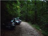
We drive to Kamnik and follow the road ahead towards the valley of Kamniška Bistrica. From the hut in Kamniška Bistrica we continue driving on the forest road which brings us higher to a crossroad, where we continue right towards Jermanca (straight starting point for Kokrsko sedlo). We follow this occasionally somewhat steeper road to a parking lot, which is located a little before the end of the road.
Driving from the hut in Kamniška Bistrica to Jermanca is now forbidden (traffic sign), which extends the path by a good hour.
Route description:
From the parking lot, we continue along the road beside which we parked. After a few minutes, the road ends, and we continue on a footpath without major ascents or descents. The path which crosses a large number of gullies then joins the path from Kamniška Bistrica (lower starting point). Here pay attention on the descent, that we go on the path by which we came. Well-marked and relatively steep path, which for some time still ascends through the forest, brings us higher to a pleasant spring (in dry periods it dries up). From the spring a short ascent follows and the path brings us to the known resting place Pri Pastirjih, where an emergency bivouac stands.
We continue straight on the marked path, which then quickly emerges from the forest onto an expansive panoramic meadow. Behind the meadow, the path goes into a belt of dwarf pines, where it starts to ascend more steeply again. The path which ahead runs on the increasingly panoramic sun-exposed slope brings us after a good hour of walking from Pastirjih to the mountain hut Koča na Kamniškem sedlu.
At the mountain hut, we turn right towards the east in the direction of Planjava (left Brana, Turska gora and Okrešelj). The path ahead crosses scree (option for descent), then becomes technically demanding. The path then ascends a wide ledge and brings us into the wall of Planjava. Fixed safety gear helps us through ledges and gullies in which there is still snow in early summer to the upper less steep slopes of Planjava. The path ahead runs over high-mountain grasses and brings us to a junction, where we go left (right Korošica). We follow the path which in places becomes quite steep towards the summit of Planjava. Just a few minutes below the summit the path from Logarska dolina and Korošica joins from the right. The path, which from here is no longer demanding, quickly brings us to the panoramic summit.
Jermanca - Pri Pastirjih 1:15, Pri Pastirjih - Kamniška koča 1:15, Kamniška koča - Planjava 2:00.

Photos:
 1
1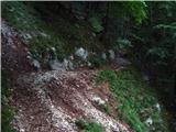 2
2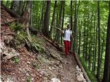 3
3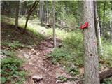 4
4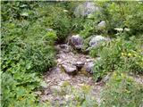 5
5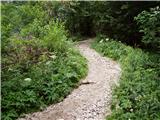 6
6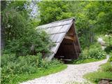 7
7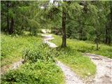 8
8 9
9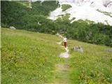 10
10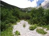 11
11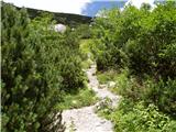 12
12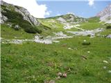 13
13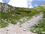 14
14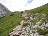 15
15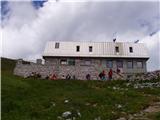 16
16 17
17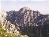 18
18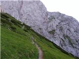 19
19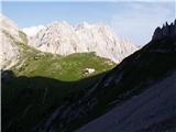 20
20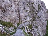 21
21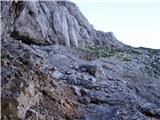 22
22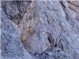 23
23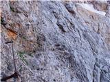 24
24 25
25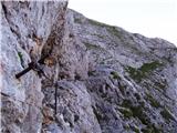 26
26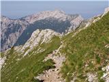 27
27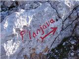 28
28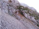 29
29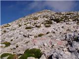 30
30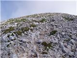 31
31 32
32
Discussion about the trip Jermanca - Planjava (via Kamniško sedlo)
Show older messages
|
| Gost27. 05. 2007 |
On Thursday 24.5. I went to Planjava from Kamniška Bistrica. The hut at Kamniško sedlo is still closed. The path further to Planjava requires some caution in places, because there is still some snow in some gullies that needs to be crossed. It took me 3.40h to the summit. The view was nice and it was worth the effort for this year's first two-thousander. From the summit there is a very beautiful view of Ojstrica, which is very close and invites you to continue the path. 
|
|
|
|
| Gost1. 08. 2007 |
Brane V.-extremely beautiful, not too long hike with just a few wire ropes. Caution is needed especially on the descent due to scree. Today was a nice day, hence also wonderful view.
|
|
|
|
| Gost25. 08. 2007 |
Today I went to Planjava via the unmarked path through Repov kot. The path is not too demanding, but there are wonderful pools along the way. Really nice path, I recommend it to you.
|
|
|
|
| Gost26. 08. 2007 |
How much time does it take from Kocbekov dom to Planjava? I was there yesterday but forgot to check, and this route isn't described online! Thanks for the info!
|
|
|
|
| Gost26. 08. 2007 |
It's 2 hours walking from Kocbekov dom to the summit of Planjava, otherwise read the description of the route Pred Belo-Planjava.
|
|
|
|
| roni15. 11. 2007 |
I walked Jermanca - Planjava (over Srebrno sedlo it's less than three hours, in between a little climb and you're quickly at the saddle and hop you're already at the top, enjoying the view
|
|
|
|
| Gost6. 01. 2008 |
Hey
I'm interested if anyone knows the condition of the north face of Planjava?
|
|
|
|
| Gost7. 01. 2008 |
The north face of Planjava is currently in winter sleep. It snowed yesterday and it is nicely white.
|
|
|
|
| roger14. 08. 2008 |
On 13.8 I set off with my cousin on the mentioned path. Initially we planned ascent to Grintovec from Kokrško sedlo but we missed the turn-off to Kokrško sedlo and drove to Jermanca. There we decided to go to Planjava. I have to admit that the ascent to Kamniško sedlo tired me more than expected, it took us about 2 hours 15 min. In the hut we stopped for tea then continued to Planjava. On the way to the saddle a lady warned us about possible wind that prevented her ascent from the saddle to one of the nearby peaks the day before. Fortunately no wind issues on ascent, the only problem were heavy legs that prevented normal ascent. After a good two hours we finally reached the goal. On the top it was quite windy, but the view served us well. The best view is to the neighboring Ojstrica, which I might visit in September, from the top there's also a very nice view of the other Kamniške Alpe. On descent we took time for jota with sausage, which by the way is very good then we hurried down the scree to the shepherds from where in less than an hour we reached the starting point. then we hurried down the scree to the shepherds from where in less than an hour we reached the starting point.
Nice hiking greetings!
|
|
|
|
| matjazD10. 10. 2008 |
Hi! Today we set off on the mentioned path, to the saddle it took us one and a half hours, to the top of Planjava another something like that. All together 3 hours with breaks  The weather was less pleasant, but it cleared up just at the top and you could see far to the north side (Logarska dolina). We also treated ourselves to a good meal at the saddle, then through scree to the shepherds.. nice trip The weather was less pleasant, but it cleared up just at the top and you could see far to the north side (Logarska dolina). We also treated ourselves to a good meal at the saddle, then through scree to the shepherds.. nice trip
|
|
|
|
| jersy10. 10. 2008 |
matjazD, was the path dry?
|
|
|
|
| BACEK JON12. 06. 2009 |
Does anyone know how much snow is still on the path between Kamniško sedlo and Planjava and what the path is like?
|
|
|
|
| tom666624. 06. 2009 |
On Sunday, 21.6. (first summer day!!) my colleague and I went from Jermanca via Repov kot and Srebrno sedlo to Planjava and back via Kamniško sedlo. Conditions below Planjava still quite wintry, especially careful due to snowfields (also on descent to Kamniško sedlo), one of them almost impassable, I mean the one on the path from Srebrno sedlo towards Planjava. Definitely recommend appropriate gear (crampons, ice axe).
|
|
|
|
| Karatko24. 07. 2009 |
Does anyone know how much snow is left on the path between Kamniško sedlo and Planjava and what the path is like?
Now?
|
|
|
|
| pikec124. 07. 2009 |
I was yesterday from Repov kot over Srebrno sedlo to the summit and back towards Kamniško sedlo. No snow or you cross 1m of snow. You can bypass it. The path is fine, only yesterday it was gusting over 100km/h. No problem to go. ajde
|
|
|
|
| BojanGams10. 08. 2009 |
9 August. The path to Planjava took me 2 hours, as it was my first trip to this mountain. Caution especially on the descent from the top. Best regards and good luck
|
|
|
|
| miham28. 08. 2009 |
Some pegs on Planjava are quite loose. They hold in principle, but still be careful.
LP,
Miha
|
|
|
|
| miham28. 08. 2009 |
I mean the two pitons on the ledge above the snowfield.
LP,
Miha
|
|
|
|
| Pohodnik1112. 09. 2009 |
Nice trail, not too demanding. I started at 6:20 and was at the summit by 9:05. I'm not super fit but have quite a few hiking kilometers behind me. Along the way I met 5 chamois, weather was great. Nice view from the top to Logarska dolina, Velika planina and Ojstrica. Recommended.
|
|
|
|
| vojak2624. 12. 2009 |
I was there today, strongly recommend crampons, weather was very bad today so it was quite eventful... unfortunately didn't see the summit...
|
|
|
|
| klm11. 07. 2010 |
This morning I set off quite late (at 9am) to Bistrico (luckily I'm from under the Kamnik mountains). Then in front of the hut I see an endless row of parked cars. Where on earth are their owners, as I could count those around the hut on one hand. I find a suitable parking spot, then dash towards Kamniško sedlo. And it begins: I meet the first group, then the second, third, and soon stop counting-damn, today is the day of Kamnik hikers!?! That's why there was such a crowd in the parking lot in front of the hut. I reach the saddle in 1:13 h, look towards today's mountaineering goal and rush to the foot. In the western wall of Planjava a hammer was ringing (I later met the climbing group on descent). I quickly overcome the key more difficult part, then tackle the final steep slope. Above the summit of Planjava a small cloud was circling, suggesting it might cover it. So far I haven't been lucky to gaze unobstructed from its summit to the surrounding peaks. Well, today I was lucky. The descent was predictably fast, so I was back at the start after 3h, because a divine lunch was waiting at home... the day was like a dream for Kamnik hikers, right!
|
|
|
|
| Irina9. 08. 2010 |
Yesterday we ascended Planjava via a path not among the described ones.
From Kamniška Bistrica through Repov kot valley to Srebrno sedlo then to Planjava summit, descent to Kamniško sedlo-hut and then back to Kamniška Bistrica valley.
The pristine Repov kot valley is a hidden nook of peace and quiet. On the right rise the Zeleniške špice and on the left the face of Planjava. The silence is "disturbed" only by the babbling of the stream flowing through the bed with countless pot-holes of crystal-clear water. Wonderful flowers from cyclamen to edelweiss greeted us along the path.
I'd add some photos but unfortunately I don't know how.
|
|
|
|
| lepenatka9. 08. 2010 |
I also enjoy such paths. Given that the path is unmarked, can one still orient oneself or is the path "trodden"?
Thanks for the reply and I wish you much enjoyment on your mountain rambles.
|
|
|
|
| spotonbody21. 08. 2010 |
Irina, did you perhaps go this way, because you mention Srebrno sedlo? 
|
|
|
|
| studentka6. 09. 2010 |
Yesterday, 5.9.2010, my boyfriend and I were on Planjava, because we also missed the path from Kamniška Bistrica towards Kokrsko sedlo and thus arrived at Kamniško sedlo. Our wish was to go to Grintovec.
Caution on the forest path doesn't hurt, as the sign is very small and possibly a bit unnoticeable from the car.
The path to the saddle is nice, first very flat through the forest, then it climbs at the end, but at this time of year the raspberries are ripe, so you stop a bit and eat some, and it goes easier
From the hut at Kamniško sedlo to Planjava the path is very steep in places, and the cliffs are quite deep. At the most dangerous part, where there are pegs and wire ropes, one peg is missing in the middle, the one next to it is quite loose, and if you're a bit scared it can cause panic. Otherwise, great path ahead, fog spoiled the view for us, but at moments when the sun broke through, Rinka waterfall on the other side and Logarska dolina were superbly visible.
Once I climb all the two-thousanders, I'll definitely return to Planjava. It won't hurt to wear a helmet, as there's a lot of loose rock and some might slide down onto someone else. Good luck!
|
|
|
|
| tol7. 09. 2010 |
Markings and mountain signs are not traffic signs, so there are no larger sizes either.
But I would warn everyone driving to Jermanca or to the lower station at Kokrško Sedlo.
Now there is a sign at K.B. by the house prohibiting motorized traffic, allowed only for residents.
I'm waiting for the day when the wardens go after the parked cars behind that sign. It seems to me that they will fine the most those who park right after the asphalt section of the road, even though those heading to Kamniško Sedlo will use that part of the road the least. Higher up, the wardens probably won't bother, right?
It's funny because the sign, as it is, consequently prohibits driving also for PD vehicles, so I wonder how often they violate regulations when supplying both huts?
Grega
|
|
|
|
| jprim7. 09. 2010 |
... those are exceptions, which you also find written down. And that sign has been there for a long time anyway.
Best regards!
|
|
|
|
| SilvestrO7. 09. 2010 |
Hm..., miss Grintavec and end up at Planjava instead...
... as I already mentioned somewhere,... traffic lights, traffic lights...
...but in the near future they will implant chips in heads..., at home you type the direction into the "computer" and then you don't think anymore... cool?
|
|
|
|
| klm7. 09. 2010 |
I hope we won't read in the future that someone intended to visit the Julijce, but got it wrong, or missed, and ended up under the Kamniške...
|
|
|
|
| Gorazd G7. 09. 2010 |
Wow, cynicism on the march.
But yeah, the student really deserved it for honesty.
She wrote truthfully, which counts for something.
But really ... These MOUNTAIN signs are way too small. Especially if the car windows are too tinted ...
It seems to me that something doesn't add up here ...
Bravo, Silvester! Computer, chip and traffic lights. Then maybe someone will reach the right summit.
|
|
|
|
| Žan7. 09. 2010 |
For someone who is in Bistrica for the first time (or at least not very familiar) and wants to drive to Konc, there's nothing strange if they miss the turn-off - that's nothing unreasonable or impossible, and there's no need to make fun of it!
The student deserves all praise because she made the completely correct decision and went to Planjava anyway. Most complicators would turn around at Jermanca and drive back to Bistrica by car and up the hill again - if the goal is Grintovec, then it's Grintovec.
|
|
|
|
| Bizy7. 09. 2010 |
Bravo Žan, I agree with what's written.
|
|
|
|
| sherpa7. 09. 2010 |
Come on, come on, Žan and Bizy. Silvester, Gorazd G and klm are completely right! Drive a little less and think and look a bit more, and you can read the mountaineering signs. The student wrote that she didn't see the signs from the car!
What would you two like, to nail big road signs along the forest road above the Dom v KB, which should be closed anyway, saying which road leads under Grintovec and which under Planjava?! Because if that's not done, some mountaineers will always complain that they can't even get to the base of the mountain.
|
|
|
|
| lepenatka7. 09. 2010 |
I already thought that our "irritability" towards less experienced people had passed, but probably the bad weather is causing it, so that we could release energy elsewhere.
Well, now scold me too.
I have quite a lot of mileage though.
|
|
|
|
| turbo7. 09. 2010 |
Studentka,
in a way it's an art. To go somewhere and end up elsewhere.
If you wrote that you and your boyfriend wanted to go to the mountains but ended up either in Piran or in Beltinci, I would also think a bit poorly of you 
Otherwise, if you admit it, you're half forgiven
|
|
|
|
| tol7. 09. 2010 |
@jprim
The sign has been changed, before it was driving at your own risk. But there's no sign with exceptions
|
|
|
|
| Flora17. 09. 2010 |
No, no, no, my dear mountaineers, let's rein in the horses a bit. I stopped reading the PZS forum exactly because people were constantly arguing, insulting, mocking. And I discovered this one and said to myself, look, here they really write about conditions and here and there a comment (sharp, a bit less sharp), but nothing offensive. Let's stay with that, with a higher form of communication among ourselves and let others live as they decide and not judge in advance or afterwards.
|
|
|
|
| Bizy7. 09. 2010 |
Come on sherpa, calm down a bit, for my sake you can even nail signs behind the hut, maybe you'll succeed then there really won't be a lack of starting points anymore.
The point is, when someone writes that they made a mistake (missed the turn-off), then immediately some smart ideas and some "heavy quasi" comments, be a bit understanding and a bit less smart. Everyone can easily make a mistake.
|
|
|
|
| sherpa7. 09. 2010 |
Flora wrote that it's not good to argue and such.
A little cynicism in the above comments sometimes doesn't hurt either.
No hard feelings, Bizy.
|
|
|
|
| turbo7. 09. 2010 |
In Kamniška Bistrica, first all signs should be removed, then two new ones installed. In the direction of Kamniško sedlo, a sign for Mrzla Gora, in the direction of Kokrško sedlo for Kočna.
Nejc wrote nicely: the path is important, not the goal. Or rather, the path itself is the goal. Otherwise, I don't doubt that the student had a good time. And she has another nice goal ahead (Grintovec). Whoever hasn't "kicked into the dark" yet should cast the first stone 
|
|
|
|
| jprim7. 09. 2010 |
tol
I don't mean the sign with exceptions, hey, I mean the regulation that talks about exceptions, I think, no I'm convinced I have a car license.
Can you remind me when the sign was changed?
|
|
|
|
| jprim7. 09. 2010 |
Flora1
From your statement, it seems you really haven't read it for a long time, oh also here it can sting badly, I have those experiences, but already thick skin.
Best regards!
|
|
|
|
| tol7. 09. 2010 |
I don't know exactly when the sign was changed.
But it was sometime since the beginning of summer.
Previously it said:
Forest road
Use at your own risk
Now it's no longer forest road, just a sign prohibiting motor vehicle traffic
and addition
Allowed for residents
In my opinion, it might be right to close the road from the hut in K.B. onwards.
|
|
|
|
| Flora17. 09. 2010 |
It's true, I haven't been up there for a long time and I'm already reading this. And see, if you have such experiences, I'm convinced you didn't feel good in that situation. And nobody wants others to feel bad. So let's stick to the mountains and their beauties and above all remain true mountaineers.
|
|
|
|
| jprim7. 09. 2010 |
You're right, I agree with you, maybe you'll be the one sometimes calming hot fingers, sometimes we laugh at something and then I also write something provocative, or poke the wasp's nest.
Best regards!
|
|
|
|
| bari7. 09. 2010 |
Girls, so you won't graduate.
Nobody wrote anything that would require this analysis.
Yes, jprim, exactly like that, if someone pokes the wasp's nest, you also write something provocative. Even "cvetkI" will experience this sooner or later.
This time someone wrote that because they drove on the (officially closed!) road and didn't see the mountaineering sign and therefore missed the mountain. 
|
|
|
|
| kolosej17. 09. 2010 |
Hello hikers.
We can read that there are western and eastern Planjava, the latter 2m lower than the first, and as a collector of Slovenian two-thousanders I'm interested in the route description to Planjava - eastern summit 2392m, because all comments and route descriptions refer to Planjava 2394m.
Cheers
|
|
|
|
| klm17. 09. 2010 |
Kolosej, the route description applies to the Eastern summit of Planjava. There's also the summit log there. To the western summit, which is supposedly cca. 2m higher, there's an unmarked path or off-trail, so you pick the easiest passages along the easy ridge up, down, up, down, cca 10 min., depending on how fast you are.
|
|
|
|
| mosovnik17. 09. 2010 |
Kolosej: klm has nicely explained it to you. Otherwise, you can find the route description to the west summit of Planjava on the PZS portal/forum and check it on the photos.
Good luck.
|
|
|
|
| klm17. 09. 2010 |
Mosovnik, you had nice weather! And a nice tour too! So far I haven't had the luck to stand on the summit of Planjava without it being covered in fog.
|
|
|
|
| Marky27. 09. 2011 |
On Saturday 24.9.2011 I decided for the ascent to Planjava. I parked a little above the hut in Kamniška Bistrica (before the sign closed road due to timber harvesting) and set off via the saddle to Planjava. The weather was quite favorable for hiking (neither too hot nor too cold). The ascent from the saddle to cca. 2000m a.s.l. took place in fog, while at the summit it was dreamy.. The pictures say more on M-foto.si.
Hiked the path in 3.5 hours.. Which means 2:30 hours to the saddle and 1h to the top... For the descent I needed only 2:45 hours (of which from summit to saddle only 45min).
Very few people at the top, which suited me perfectly.. Really dreamy..
|
|
|
|
| _sandra_13. 01. 2012 |
Has anyone been to Planjava this month maybe? What are the conditions like?
|
|
|
|
| U&Q13. 01. 2012 |
I was only at Kamniško sedlo today. Snow starts somewhere halfway, at first the path was icy, in the open it was soft snow, very slippery and crampons don't help much. I hope this helps somehow
|
|
|
|
| _sandra_14. 01. 2012 |
it helps, for those without crampons, so they don't push up
|
|
|
|
| _sandra_14. 01. 2012 |
you can reach the saddle with small crampons without problems, even without them it's possible, but for a "better feeling" I recommend crampons, nothing is too frozen towards the top, at least not today.
|
|
|
|
| Jonny_4. 06. 2012 |
Has anyone been there recently? How is the snow from Kamniško sedlo towards Planjava?
|
|
|
|
| velkavrh6. 06. 2012 |
I'm also interested in how the path is, as I plan to go on Saturday. Of course not if there is still any ice. Best regards.
|
|
|
|
| adnap6. 06. 2012 |
The gullies are still snowy. On Sunday 04.05. it was possible to make quite solid steps in the snow. However... a small mistake and you're prematurely in the valley. I still carry my gear with me. My crampons came in very handy on the path from Ojstrica just before Škarje. Three more photos below Planjava.
Good luck
|
|
|
|
| ssimonss16. 07. 2012 |
Can someone tell me how difficult the path to Planjava is, say compared to the ascent to Brana? Is a via ferrata set absolutely necessary or not? Thanks for the info!
|
|
|
|
| Flora116. 07. 2012 |
Subjective assessment!!! Easier, initial part has cables, but if you're somewhat experienced in high mountain hiking, the set is not needed, helmet definitely. Good luck.
|
|
|
|
| jprim16. 07. 2012 |
Both paths are marked as difficult, to me the one to Brana is easier - overall, although this path also has some harder sections, ...
@ssimonss - try it, hike it and your own assessment will be the most accurate.
Regards!
|
|
|
|
| Betoner18. 07. 2012 |
Yesterday on the trail a bit foggy, a bit windy. Self-belay kit not needed.
Luckily the weather cleared at the top and gave us a beautiful view of Logarska dolina. A chamois kept us company
|
|
|
|
| AnzeKozjek19. 06. 2013 |
Has anyone been to Planjava in the last few days? What's the path like from Kamniško sedlo onwards? Is there still any snow on the path? Thanks for the reply! Best regards
|
|
|
|
| tancib13. 08. 2013 |
Hello, I'm also curious about the path from Kamniško sedlo to Planjava. I've read the descriptions and looked at the photos and it seems doable. I'm wondering if there's still any snow anywhere, since I read that snow can still be there even in summer.
Thanks and lpp
|
|
|
|
| tinky13. 08. 2013 |
Was there a week ago. No snow on the path, but a little off-path is good for refreshment.
|
|
|
|
| tancib13. 08. 2013 |
Thanks tinky for the info. Did you perhaps continue to Korošica and then to M.Ojstrica-Ojstrica-over Škarje back to Korošica? Is there maybe some white surprise somewhere on this path? Or if someone else has hiked this path recently. Thanks, lpp
|
|
|
|
| panda13. 08. 2013 |
I don't know why such a combination: I would continue from Planjava over Bab to sedlo Škarje and Ojstrica. If the desire is strong, continue over Mala Ojstrica to Korošilo and then back to Kamniška Bistrica. The basis is of course the car in the valley and not at Jermanca. You would save quite a few elevation meters if from Planjava over Srebrno sedlo you don't descend to Korošilo and over Malo Ojstrico to Ojstrica, then down again to sedlo Škarje and ...... seems like a waste of time to me. Of course, this is just my opinion.
|
|
|
|
| tinky13. 08. 2013 |
I went to Planjava from Jermanca, through Repov kot and over Srebrno sedlo. From the saddle, no snow was visible under Škarje and towards Ojstrica.
|
|
|
|
| tancib14. 08. 2013 |
panda, I looked at this variant you mention. I'm not going alone and will adapt a bit. But we took two days of pleasure So, overnight at Korošica and second day Ojstrica and to Presedljaj and to the valley. Jump to some peak in between. How to the car, I'll think at the end in the valley
tinky, great ..so no white surprises
lpp and light steps around
|
|
|
|
| mukica16. 09. 2013 |
On the path you're asking about there's no more snow, I personally went alone from Kamniško sedlo to Planjava, and up there we chatted with cyclists who had come and also descended by bike to Korošica...
|
|
|
|
| Jurij-Jure28. 09. 2015 |
Hello. I'm heading out tomorrow and I'm interested in the current conditions, if anyone has been up there recently :-). Thanks and best regards
|
|
|
|
| Jigga4. 05. 2017 |
Did it with a buddy this weekend. Extremely tough conditions, I can safely say deadly dangerous from the Sedlo onwards to Planjava. Everything covered in snow that's soft and partly wet as the sun melts it.
|
|
|
|
| Afrofeet21. 06. 2017 |
Can you drive to Jermanca by car?
|
|
|
|
| grega_z_brega21. 06. 2017 |
By the end of the week, the road will also be fixed.
|
|
|
|
| Anchan8. 10. 2017 |
Just for info, today visited the path, it was mostly dry, a couple of snow crossings, that's it. Road in a bit poorer condition, but that's expected end of season
|
|
|
|
| pohodnica1114. 05. 2018 |
Hello,
Yesterday 13.5.2018 on this trail. Parked 5 min below Jermanca, further on the road is quite damaged. Trail to the hut at Kamniško sedlo OK. After 20 min walk from the hut and crossing 3 snow fields, turned back. Would have to cross a 30m long snow field on quite a steep slope, plus the snow is soft and very dangerous.
|
|
|
|
| Turbolazec21. 05. 2020 |
What are the conditions like, has anyone been on this path recently? Thanks
|
|
|
|
| Kanjanez27. 08. 2020 |
We did Brana and Planjava as a package, early start, nice sunrise at the saddle.
Given the busy GRS weekend (18 interventions in just 3 days!) I warn that for this package you need lots of energy, water, time, even though there's a hut.
Let's be responsible to ourselves and others.
|
|
|
|
| andraja5. 10. 2022 20:07:33 |
What is the current condition of the road to Jermanca?
|
|
|
|
| grega_z_brega5. 10. 2022 23:25:15 |
Normally drivable.
And don't cut the hairpin bends, so it stays that way.
|
|
|
|
| andraja8. 10. 2022 07:51:41 |
Thanks for the kind reply. I was there yesterday and the road is really good.
|
|
|
|
| Po Hodnik10. 10. 2022 22:43:32 |
Jermanca normally drivable - exception the last bend before the parking lot, where caution is needed.
Started with headlamps, lots of people on Saturday. Well protected trail, SVK not needed. Helmet essential. Rocks were triggered above us several times and flew directly over someone's head 100 meters ahead of us. Especially on descent there was a lot of crumbling rock.
Return shortened a bit via scree. Nice trip.
|
|
|
|
| JohnBrown20. 06. 2023 15:25:03 |
18.6 Path over Repov kot and descent to the saddle. For descent to the saddle, need to cross snow-covered basin. For the medium experienced, light snow gear is almost necessary.
|
|
|
|
| julius21. 06. 2023 14:16:13 |
BASIN ?????
snow-covered basin ????
|
|
|
|
| Jusk21. 06. 2023 18:25:36 |
Uvala is otherwise a karst phenomenon, something similar to a vrtača, or larger than a vrtača
|
|
|
|
| Zdenkob18. 07. 2023 17:48:15 |
Yesterday I took this path to Planjava. No snow left on the path anywhere, but it's well strewn with scree, so caution on the descent is advisable.
|
|
|
|
| gipeon12. 06. 2025 19:40:42 |
Path done today, I parked down at Koča v Kamniški Bistrici as described (a couple hundred meters further right from the hut) from there there's a sign to the saddle 3.5 hours and to Planjava 5.5h. But from that parking there's also a sign parking Jermanca, which obviously leads to an even higher parking lot, the road seemed open.
The path itself is not demanding, but helmet is mandatory. You meet chamois on the way that diligently kick stones, if you start early enough of course. Had to cross three snow patches about 10m each, nothing special, but a slip there can be fatal, not recommended for inexperienced. I had mini crampons and poles and it was OK.
|
|
|
|
| larica7. 08. 2025 07:12:10 |
Hi, does anyone know what the current condition of the road to Jermanca is?
Thanks for the reply.
|
|
|
|
| garmont7. 08. 2025 09:11:54 |
Two days ago I parked at Konc.
The road is excellently maintained. I assume it's the same further to Jermanca.
|
|
|
To post a comment you must log in:
If you do not yet have a username, you must first
register.