Starting point: Jekarica (994 m)
| Latitude/Longitude: | 46,3602°N 14,4244°E |
| |
Walking time: 3 h
Difficulty: difficult marked way
Elevation gain: 1138 m
Elevation difference along the route: 1138 m
Map: Karavanke - osrednji del 1:50.000
Recommended equipment (summer):
Recommended equipment (winter): ice axe, crampons
Views: 50.658
 | 4 people like this post |
Access to starting point:
From the Ljubljana - Jesenice highway, take the Kranj - east exit and follow the road ahead in the direction of Jezersko, but only to the inn Kanonir, where we turn left and follow initially the still asphalted road. At all crossroads, we head towards the signs for Storžič. When the road makes a sharp right turn, we notice signposts for Kališče and Storžič. We park on the parking lot near the signpost in such a way that we don't hinder forestry work. The road is from 20.7. to 20.10. CLOSED. When the road is closed, we park lower, which extends the ascent by one hour.
Route description:
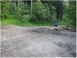
At the bend, turn onto the cart track to the left of the signposts. Already after a few metres, notice the marking on a tree, telling us we are on the right path. After good five minutes of walking, a signpost directs us left onto the footpath. The path, which starts moderately ascending, soon brings us to a cart track, which we only cross. The path just a minute further again crosses the cart track, then ascends more steeply. The path slowly turns slightly to the left and brings us to a small ridgelet, where we get very close to the cart track. For some time we ascend alongside the cart track, then the pathlet brings us to a viewpoint where a bench stands. The path ahead again brings us onto the cart track, but this time to the place where it ends. Access via the cart track is also possible (at all junctions keep to the left directions, the start is the same). The path ahead is somewhat harder to follow since large quantities of fallen trees prevent ascent along the marked path, so it is necessary to find passages, which are only partially trodden. Once we overcome this section, the path is again easier to follow, but only briefly. The path ahead approaches a clearing located below Storžič and turns left among fallen trees. Again we search for passages among the trees. A few metres before Praprotnikova hut we step again onto the marked path, by which we reach the hut in a few steps. The path ahead ascends steeply again, then turns right and crosses the slopes in a gentle ascent to the scree deposited by the torrent. The path ahead leads between two boulders and after a few steps descends before ascending again. Soon we reach dwarf pines, where the view opens. The path ahead ascends below the walls of Bašeljski vrh, which we bypass along the lower side. First we cross a smaller scree, then the path brings us into a gully located among dwarf pines. The ascent through the gully is not demanding but caution is needed, especially on descent due to scree on the rocky base. The path from the gully brings us to a pleasant meadow on which the view to the south side opens. At the signposts, turn right towards Storžič (left Kališče). The path, which starts steeply ascending through dwarf pines, brings us after 30 minutes of ascent to the ridge of Storžič. The path soon withdraws from the ridge to the steep southern slopes of Storžič. This part of the path is dangerous for slipping; in wet conditions great caution is needed. The steepness then eases somewhat, and the path continues along the ridge or slightly below it. A few metres below the summit we join the path coming from Žrelo (also from mountain pasture Javornik and from Psica). We continue right and reach the summit, where a cross stands, in a few steps.
Jekarica - Bašeljsko sedlo 1:45, Bašeljsko sedlo - Storžič 1:15.

Photos:
 1
1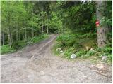 2
2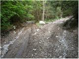 3
3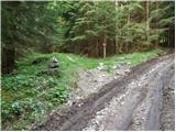 4
4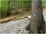 5
5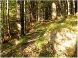 6
6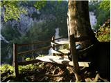 7
7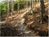 8
8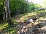 9
9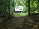 10
10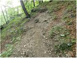 11
11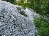 12
12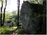 13
13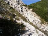 14
14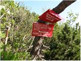 15
15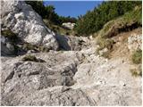 16
16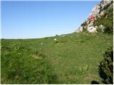 17
17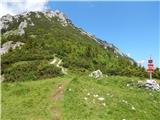 18
18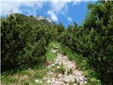 19
19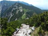 20
20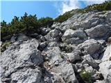 21
21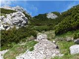 22
22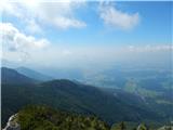 23
23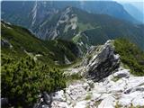 24
24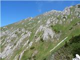 25
25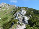 26
26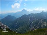 27
27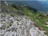 28
28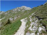 29
29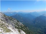 30
30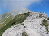 31
31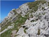 32
32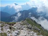 33
33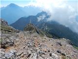 34
34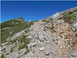 35
35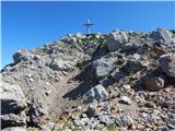 36
36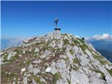 37
37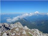 38
38 39
39
Discussion about the trip Jekarica - Storžič
|
| velkavrh10. 07. 2008 |
Went on this variant to Storžič today. It's my favorite and also the shortest, if the road is of course still open. Nice weather, lots of hikers. You can already tell that vacations have started and basically every nice day is seized.
|
|
|
|
| nevi26. 08. 2009 |
Does anyone perhaps know if the road is open, what's its condition?
|
|
|
|
| lucy69. 09. 2009 |
The road is currently not open, it opens in October.
|
|
|
|
| klavdy627. 09. 2009 |
Road closure greatly extends the trip otherwise very nice otherwise very nice
|
|
|
|
| crniracek8. 10. 2009 |
How is it with the road? Does anyone know if it's open yet?
|
|
|
|
| klavdy69. 10. 2009 |
opens on 20 October 
|
|
|
|
| sumpi11. 12. 2009 |
I'm just wondering how to get to the top without the road
|
|
|
|
| Gorazd G12. 12. 2009 |
Yes, but I get it, someone wants to avoid walking on the road. It'll be tough...
|
|
|
|
| panoramik19. 06. 2010 |
I'm interested in the condition of the road through Jekarica and whether the path onwards to Storžič is snow-free.
|
|
|
|
| Klin22. 06. 2010 |
The path from Bašeljski preval to the top of Storžič is dry. I don't know the current condition of the road.
|
|
|
|
| Ceri6. 02. 2011 |
today I went up this trail to Storžič  the road is snowy but drivable ... sections with fallen trees are not problematic, because of the snow and visible track ... a bit more caution needed on icy sections, because I, the optimist, left crampons at home the road is snowy but drivable ... sections with fallen trees are not problematic, because of the snow and visible track ... a bit more caution needed on icy sections, because I, the optimist, left crampons at home  otherwise great trip and wonderful views otherwise great trip and wonderful views
|
|
|
|
| minca236. 02. 2011 |
Bravo Ceri and thanks for the great idea for tomorrow. And let me confirm it's really that nice . best regards, Minca . best regards, Minca
|
|
|
|
| panoramik28. 06. 2011 |
On Sunday I went on this path to Storžič. Road through Jekarica is nicely drivable to the parking lot approx. 4.6 km from guesthouse Kanonir. Weather was a bit cloudy but pleasant for hiking. Views were not lacking either. All in all the right decision at the last moment (I had planned Grintovec, which was in clouds all day). Recommended.
|
|
|
|
| jurre15. 03. 2012 |
Has anyone hiked Storžič recently? What are the conditions like? Thanks for the reply.
|
|
|
|
| velkavrh17. 03. 2012 |
jurre, if you look under forum-Storžič Marko1 wrote that for the path from Kališče to Storžič you don't need ice axe or crampons. From the valley it's visible that it's almost dry. From Jezersko via Jekarica the path is really pleasant, only from the ramp to the starting point it drags a bit. If you go, take some pictures.
|
|
|
|
| nevica24. 03. 2012 |
Today my colleague and I hiked the described trail. Some snow in places, sinking deeply, otherwise nice, somewhat less visited path.
|
|
|
|
| Sobota17. 07. 2013 |
Hello,
does anyone know if the road is passable?
Thank you!
|
|
|
|
| katty18. 07. 2013 |
Hi....
Tomorrow I plan to do this: in the morning take the bus to Kanonir and then walk to the usual starting point for Storžič and ascend via Jekarica, descend via Javorniški preval....
So I'm interested in the following: approximately how long does it take from Kanonir to the starting point and how long should the descent take....
Thanks for any info.
Good luck to all!
Katty
|
|
|
|
| otiv18. 07. 2013 |
@katty from Kanonir to the starting point is about 1.5 hours walk. The whole tour is a full-day one, so check the timetable back to Kranj
Good luck on the trail!
|
|
|
|
| magroman4. 03. 2014 |
Is the road drivable to the parking lot at the signs for Kališče-Storžič? I would probably go on Saturday.
best Roman
|
|
|
|
| velkavrh19. 05. 2014 |
I'm interested if the mountain road to Jekarica is passable - cleared of trees and rocks. How is it with the ramp?
|
|
|
|
| kgregor16. 06. 2014 |
Since there has been no response for a long time, I am also asking the same question... Thanks in advance for the answers.
|
|
|
|
| ljubitelj gora16. 06. 2014 |
A month ago it was abandoned and the barrier was up, what happened there in the meantime I don't know. Above the road there is a danger that some broken tree might roll down, so be careful with the car.
|
|
|
|
| kgregor17. 06. 2014 |
thank you very much for the answer
|
|
|
|
| Grenaleva7. 07. 2014 |
We took this path on Saturday 5.7. The barrier is still open, the road to the starting point is nicely drivable (until 20.7.). The first part of the path to Bašeljski preval is nicely in the shade, but here and there in the forest due to fallen trees you need to watch the markers more carefully. At the starting point there is a sign for Storžič 2.5 hours, 1.5 hours to Bašeljski preval and another hour of steep climb to the top. The time is realistic, we only walked the last part of the path a bit slower, because due to hikers who were already returning we waited several times to space ourselves out nicely, and we were quite tired. At the top all the effort pays off, because Storžič offers a magnificent view.
|
|
|
|
| MatijaKos13. 06. 2015 |
Today I walked the trail described above. The road to the starting point is in good condition. The path to Bašeljski preval is mostly cleared of fallen trees and the markings have also been renewed, so there are no orientation problems.
|
|
|
|
| Zvonček20. 11. 2016 |
Has anyone perhaps gone from Jekarica to Kališče in the last week? What is the condition of the road to Jekarica?
The rain probably melted the snow.
Thanks in advance for the answer?
|
|
|
|
| zeti22. 11. 2016 |
Was there a while back. 30.10.2017, so before the snow but I think the snow has already melted - none in the chambers. Right after HE Zabukovje the road is very bad (mud), where they load wood, so I almost turned back, then it becomes nice again
|
|
|
|
| Zvonček23. 11. 2016 |
Zeti, thanks. Due to the snow which of course has melted in the meantime, the section of road at HE Zabukovje is probably even muddier. If it doesn't go, I'll turn back. It'll just be an hour more walking.
|
|
|
|
| magroman31. 05. 2018 |
Maybe someone went from Jekarica recently. Can you get to the parking lot, or are the foresters logging full on?
|
|
|
|
| mornar18. 06. 2018 |
Has anyone walked this path, what are the conditions and how is access to the parking lot, L, P
|
|
|
|
| devill20. 06. 2018 |
Was there 10.6.2018 car access no problems, just at one spot a bit careful (deposited stones) otherwise path without features some fallen trees which don't cause issues, good luck LP
|
|
|
|
| andrus26. 09. 2018 |
Has anyone been on this path recently? I'm interested if the road is open and what condition it's in?
|
|
|
|
| potpodnoge27. 09. 2018 |
Well described path, like all the other paths. In my opinion, only the date of the description is missing in the header of all entries.
|
|
|
|
| potpodnoge27. 09. 2018 |
Well described path, like all the other paths. In my opinion, only the date of the description is missing in the header of all entries.
|
|
|
|
| macgyveram14. 07. 2019 |
Was there today and took the opportunity to drive to the bend. The road is good, even better than to the barrier. The sign says it will be closed to traffic on 20.7. If anyone is interested - from the barrier to the bend it's exactly 3.0 km.
|
|
|
|
| jugova.frajla10. 01. 2020 |
Has anyone been on this path recently? I'm curious about the road or how far you can get by car? thanks
|
|
|
|
| nkamin13. 08. 2025 11:25:01 |
I'm interested if the road to the starting point is drivable and what condition it's in.
|
|
|
|
| bbugari113. 08. 2025 18:09:44 |
The road is ok - up to the barrier where it says it's closed further on. Park there and continue on foot
|
|
|
To post a comment you must log in:
If you do not yet have a username, you must first
register.