Jasna - Ciprnik (via Mojčin dom)
Starting point: Jasna (827 m)
| Latitude/Longitude: | 46,4753°N 13,7819°E |
| |
Route name: via Mojčin dom
Walking time: 3 h
Difficulty: easy marked way
Elevation gain: 918 m
Elevation difference along the route: 965 m
Map: Kranjska Gora 1:30.000
Recommended equipment (summer):
Recommended equipment (winter): ice axe, crampons
Views: 109.652
 | 4 people like this post |
Access to starting point:
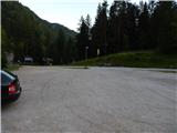
A) First, we drive to Kranjska Gora, and then we continue driving towards Vršič. Already soon after that, when Kranjska Gora ends, we cross the Pišnica river and only a few dozen meters further we turn right onto a larger parking lot, where we park by the lake Jasna.
B) We drive to Trenta, and then through the Vršič pass we drive towards Kranjska Gora. When we get to the lake Jasna we park on a large macadam parking lot by the lake (the parking lot is located on the left side of the main road).
Route description:
From the parking lot we walk a few steps along the road in the direction of Kranjska Gora, then behind a smaller dam we continue left along the gravel bed of the Pišnica. The path ahead leads us on a concrete embankment, then we enter the forest, through which we start ascending. At the beginning the path leads past more crossings, and we follow the signs for Vitranc or Ciprnik. A little higher we get to a crossing, where straight ahead used to continue the path to Mala Pišnica (path is damaged, impassable, dangerous and therefore closed), and we continue right and start ascending steeper in zig-zags. For some time we ascend relatively steeply, then the path turns right and crosses the slopes of Vratnik (Vratnik is part of the eastern ridge of Vitranc). Further, we again ascend in a few hairpin turns, then we get to a crossing, where we continue left, steeply upwards (if we continue straight we get to Kranjska Gora ski slopes, also from there it is possible to ascend to Vitranc). Next follows a very steep ascent, then we reach the main ridge of Vitranc, where the path turns right and continues on or slightly along the ridge. The path ahead is most of the time still pretty steep, but higher the steepness decreases. A little further, the path moves away from the ridge to the left and flattens, so that we reach Mojčin dom with a gentle to moderate ascent.
From Mojčin dom, near which there is also the decaying Dom na Vitrancu, we continue straight to a crossing a few dozen steps away, where the path from Kranjska Gora joins from the right.
Again we go straight in the direction of Ciprnik, where the path also leads past the decaying one-seater chairlift Vitranc II.
(The one-seater chairlift Vitranc II is the oldest one-seater chairlift in Slovenia and one of the oldest in the world as it bears the year 1958. A few years ago it was still possible to ride it safely to Vitranc, today it no longer has an operating permit).
The path continues along the ridge of Vitranc with some shorter ascents and descents, then we get to the spot, where the path from Planica also joins from the right.
We continue straight on a gradually steeper path, which higher takes us out of the forest into the belt of dwarf pines. The steep path, along which there are some fixed safety devices further on that are not necessarily needed, then leads us all the way to the scenic Ciprnik.
Jasna - Mojčin dom na Vitrancu 2:15, Mojčin dom na Vitrancu - Ciprnik 45 minutes.
Description and pictures refer to the condition in the year 2016 (June).

Photos:
 1
1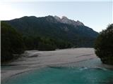 2
2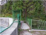 3
3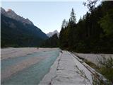 4
4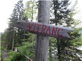 5
5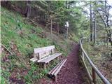 6
6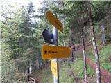 7
7 8
8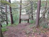 9
9 10
10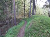 11
11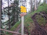 12
12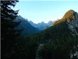 13
13 14
14 15
15 16
16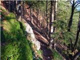 17
17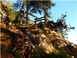 18
18 19
19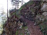 20
20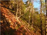 21
21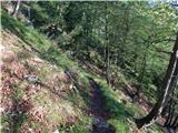 22
22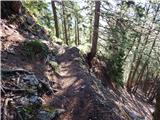 23
23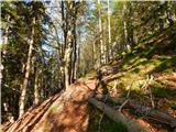 24
24 25
25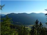 26
26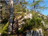 27
27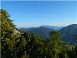 28
28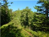 29
29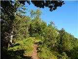 30
30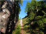 31
31 32
32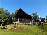 33
33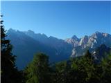 34
34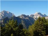 35
35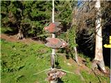 36
36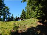 37
37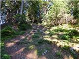 38
38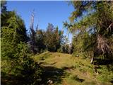 39
39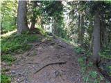 40
40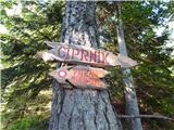 41
41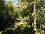 42
42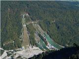 43
43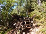 44
44 45
45 46
46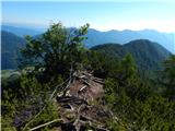 47
47 48
48 49
49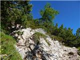 50
50 51
51 52
52 53
53
Discussion about the trip Jasna - Ciprnik (via Mojčin dom)
|
| tisa1. 11. 2010 |
How clumsy of me to submit the trip rating while browsing Kamnik Alps trips. Well, early October I marched or rather rode the cable car to Vitranc then trail to Ciprnik. Weather indescribable, even saw Grossglocner, let alone our mountains. Could almost grab Jalovec by hand, gently stroke Ponce. Unique. Recommend to all if another crystal sunny day. Good luck!
|
|
|
|
| darh31. 07. 2011 |
We climbed it at the beginning of the month from Planica. Nice path, wonderful views from the top. I can only recommend it. I posted pictures and the track of our path here.
|
|
|
|
| limona229. 08. 2011 |
Ciprnik from Planica, from Dom v Planici - a few days ago we went again on this path, which "darh" described nicely. On the return, however, we decided to descend to Planica on another path that branches off somewhere in the middle for a change. At this junction there is also a red sign, pointer "Planica". You really get to Planica (near the entrance to the path to Tamar), but this sign shouldn't be there, because the path is dangerous! It's not for ordinary hikers who might circle down from Vitranc and Ciprnik towards Planica! It runs through a very steep, gravelly, broken gully, where it's hard to find a stable rock to step on or hold onto. Only after returning did I check that Mihelič also described this path in the guidebook as barely passable, once marked, then abandoned, unfinished and unsecured. At certain points it is completely overgrown with bushes, but at least stable there. At some points there was no other way down the slippery slope than partially hanging on a bushy branch to the next step. Willy-nilly you dislodge stones. Probably a bit easier uphill, provided you can even find the starting point in the extensive scree gravel slide. This part of the "path" is only for those with a lot of mileage in the mountains.
|
|
|
|
| robi1419. 02. 2012 |
Yesterday (18.02.2012) we were on Ciprnik from Kranjska Gora.
From the end of the Vitranc I chairlift station we were breaking trail in snow. At the station approx 50 cm, in the forest much less, at the top of Vitranc good half a meter. From Vitranc to the last ascent the path was fine, only here and there it sank to our butts. The last ascent was quite demanding, but the summit outweighed all efforts.
Views phenomenal, weather even better.
Back we headed to Planica. Also here on the path no major problems, only from the wooden hut to the valley, the descent was a bit "tricky", because the snow was very wet, i.e. in places there was none at all, or it was mixed with leaves.
In general, we made a nice track, which today's snow will cover...
Super trip and also panorama from the top!
|
|
|
|
| darh15. 08. 2013 |
About a week ago, after two years, we went to Ciprnik also from Vitranc. We just replaced the cable car ride with an ascent along the ridge from Lake Jasna. The path is modestly marked, but easy to follow and offers nice views. Detailed description and photos I posted here.
|
|
|
|
| mihaj20. 07. 2014 |
Nice mountain greeting! It would be worth saying that the single chairlift Vitranc II is not running, and a replacement with a newer one, which was talked about a few years ago, is also not in sight. So it is necessary to get to Dom na Vitrancu, which is sadly decaying, on foot. Fortunately, the ascent is still more than worth it, as there is the charming Mojčin dom. But families with small children will need at least one hour if not more for the path to Mojčin dom, from where it is then one hour to the top of Ciprnik, along a fairly slippery path. Nevertheless, I recommend the visit. But if two hours of walking haven't deterred you from the visit, I still recommend the path from Planica. It is beautiful and gentle. Plenty of mountain pleasures.!
|
|
|
|
| prizup10. 06. 2015 |
The path from Planica to Ciprnik-Vitranc, which until recently was full of fallen trees, is now cleared and nicely passable. Soon a tourist bus will run to Planica and it will be possible to make a nice circular tour along the ridge to Jasna.
|
|
|
|
| valerija1126. 07. 2015 |
But maybe someone knows if this chairlift is running this year.
Thanks and best regards.
|
|
|
|
| GregorC7. 07. 2015 |
The Vitranc 1 chairlift is running (every day from 9.00 to 17.00). From the top of this chairlift onwards to Ciprnik you have to go on foot. LP
|
|
|
|
| pemi14. 09. 2015 |
How long is it from the top of chairlift 1 to Mojčin dom?
|
|
|
|
| prizup14. 09. 2015 |
Chairlift runs until the end of October on Fridays, Saturdays and Sundays. From the chairlift to Mojčin dom is a good hour.
|
|
|
|
| pemi14. 09. 2015 |
super, thanks,
so from chairlift to hut about an hour and then another hour to Ciprnik, maybe someone knows approx how many elevation meters, it's because we have a 3-year-old child, otherwise walks in mountains fine, if not much elevation..around 400 
|
|
|
|
| valerija11214. 09. 2015 |
Upper station Vitranc1,(Bedančev dom)-1116,Mojčin dom-1555(here the world stands a bit upright,but the path is nicely laid out),Ciprnik-1745(this part is pure enjoyment). We walked the path on Saturday. Met quite a few small smiling Kekcev. Really nice. Good luck.
|
|
|
|
| pemi14. 09. 2015 |
super, thanks Valerija 112
|
|
|
|
| prizup28. 12. 2015 |
The trail from Jasna to Vitranc is completely dry. Last weekend it was 15 degrees on Vitranc, Teloh grows along the trail. You can also reach Ciprnik without crampons, though small crampons wouldn't hurt. On the ski slope trail, small crampons are recommended to bypass icy spots.
|
|
|
|
| Salewa11. 02. 2016 |
How much walking is there from the Kranjska Gora ski slope to the top of Ciprnik? Does the chairlift operate at this time?
|
|
|
|
| BSAE16. 03. 2016 |
Maybe someone knows what the current trail conditions to Ciprnik are? We plan to watch the alpine flights a bit differently ... from the viewpoint.
|
|
|
|
| BSAE16. 03. 2016 |
Thanks.
|
|
|
|
| lakkon21. 01. 2018 |
what is the condition of this trail? amount of snow? trodden? additional hazards in winter?
|
|
|
|
| tango15. 11. 2018 |
Pleasant hike, but what when at the top (around ten) fog greeted us instead of spectacular views. You could only feel the sun, so repetition is necessary. The path is otherwise nicely cleared, although quite a few spruces fell across it in the last windstorm.
|
|
|
|
| devill21. 02. 2019 |
Does anyone know the current path conditions to Ciprnik?
|
|
|
|
| Jusk21. 09. 2019 |
Today at Ciprnik last year I walked this path but only to the top of Vitranc, today I said let's go to the end of the path already on the way nice views, at the top especially otherwise to Mojčin dom the path is really knee-grinding but if you have good fitness no panic. Not a lonely path, met quite a few hikers. Nice views from the top
|
|
|
|
| CarpeDiem24714. 03. 2021 |
Yesterday up here. I recommend ABSOLUTELY crampons, because some go to Ciprnik only in hiking boots, and then in two steep sections for descent they have considerable difficulties. Today new snow and other conditions anyway.
|
|
|
|
| Lazo24. 06. 2021 17:10:39 |
The trail was unremarkable, but not entirely innocent regarding the ascent. Towards the top, we find "zajle" (fixed cables), which are not superfluous, especially on the descent (I used them a little). Almost the entire trail is on a forest path, which is very handy if you don't start early in the morning.
On the trail, we encountered two chamois, so I still recommend some stealth, as they triggered rocks at us.
The view from the top is phenomenal and rewards all the effort we put into the ascent.
The entire trail, if someone is not confident.
https://www.youtube.com/watch?v=GzGlosU3Em4&ab_channel=%C5%BDANLaznik
|
|
|
|
| Val18088. 07. 2022 16:00:35 |
Today it was dreamy!
|
|
|
|
| tango11. 09. 2023 17:02:11 |
Beautiful day, good visibility, completely different from 2018 when we wandered in the fog. The only mistake was deciding to return via the ski slope, as the paved road doesn't suit us best, so we turned towards Jasna at Bedanc. Some fallen trees, but the detours are already quite solid. The forest is extremely dry and accordingly dusty, so bathing in Jasna was quite welcome and devilishly refreshing.
|
|
|
|
| Barbara 755. 02. 2025 16:50:11 |
Hey hikers, please info on conditions at Ciprnik
Thanks for reply
|
|
|
|
| plaNinaPirsMajcen1. 12. 2025 18:55:49 |
Hi, last Saturday there was a winter idyll on Ciprnik. Path trampled, quite some snow, crampons mandatory. The view of Jalovec really enchanted me.
More in the video:
https://youtu.be/PnSnxcYwYLQ?si=UOPnMkMKmcpkf5cZ
Mandatory stop also at Mojčin dom for goulash and Turkish coffee 🙂 the caretakers are very friendly.
Best, Nina
|
|
|
|
| turbo3. 12. 2025 09:08:05 |
Shame you're still posting here. It should be in Forum - Conditions.
|
|
|
|
| plaNinaPirsMajcen5. 12. 2025 19:35:12 |
Turbo, read some comments above, at least three are asking about conditions. Some describe their path experience, advise others. I don't know why my comment should bother you. Here you have a specific trail to a specific mountain and it's right to comment here. In the current conditions forum you might not find exactly the info you're interested in. Best
|
|
|
|
| mirank5. 12. 2025 21:49:23 |
Bojan is right, by the way, the remark isn't just for you. The section title itself says enough that this is the right place for supplementary descriptions of the route to the location. Besides, the duplication of the same tour descriptions here and under current conditions bothers me too. Otherwise the forum is fine, no hard feelings
|
|
|
|
| ločanka6. 12. 2025 06:39:17 |
Of course turbo is right. Those of you who joined recently are mixing this up or not distinguishing it. Here you comment on what has changed compared to the description or give your opinion on the accuracy of the description and perhaps various additions. The rest are current conditions.
|
|
|
|
| Enka6. 12. 2025 12:30:47 |
It is true that we have a forum for conditions. It is also true that we can walk this trail in dry conditions (as described and supported by photos), and also in winter. How the trail looks in winter, everyone can now see in Nina's video. It is clear that conditions change in winter, but those who hike in the mountains in winter will know how to assess how comparable it is to the current conditions. After all, some tours are already accompanied in the basic description by winter photos (which don't help me much in summer). Therefore, I see nothing wrong with posting such a video under the trail description as well.
However, I absolutely do not support only describing current conditions and inquiring about them here, among the trail descriptions.
|
|
|
To post a comment you must log in:
If you do not yet have a username, you must first
register.