Jablance - Koča na Bohorju
Starting point: Jablance (500 m)
| Latitude/Longitude: | 46,0467°N 15,4454°E |
| |
Walking time: 1 h
Difficulty: easy marked way
Elevation gain: 396 m
Elevation difference along the route: 396 m
Map: Posavsko hribovje Boc - Bohor 1:50.000
Recommended equipment (summer):
Recommended equipment (winter):
Views: 39.134
 | 2 people like this post |
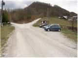
Access to starting point:
From Krško we drive towards Sevnica or vice versa. Soon after Krško, the road branches off to the right towards Brestanica (from Sevnica, a little before Krško, to the left). We follow this road ahead towards Senovo, where we notice the first signs for Bohor (in Senovo we turn left). The road, which then runs along the stream upwards, brings us higher to a poorly marked crossroad, where we continue slightly left upwards (the road which goes straight, still along the stream, brings us to the mountain hut Koča na Bohorju. Our left road then makes two sharp turns and soon brings us out of the forest, where after additional 100 meters of driving, we park on a parking lot by the information board.
Route description:
From the parking lot, we continue on the right road in the direction of the mountain hut Koča na Bohorju. After a few minutes of walking, the blazes point us to the right on a wide footpath which moderately ascends through the forest. When we come out of the forest, the path turns left and then crosses a grassy slope (badly marked). This path which is ascending by the fields we follow towards the houses in the village, which we see in front of us. In the village we step on the road on which we then walk a few dozen steps, to the chapel which we see on the left side of the road. Behind the chapel, we continue on a marked footpath which ascends parallel with the road. The path which is ahead very well-marked, through the forest and some smaller meadows in a moderate ascent brings us on an asphalt road which we follow to the left. The road on which we walk, then in three minutes brings us to the mountain hut Koča na Bohorju.
Photos:
 1
1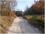 2
2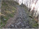 3
3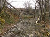 4
4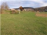 5
5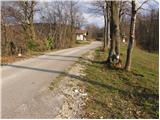 6
6 7
7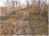 8
8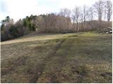 9
9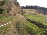 10
10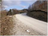 11
11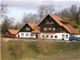 12
12
Discussion about the trip Jablance - Koča na Bohorju
|
| fpetel17. 04. 2008 |
The place where the parking lot is is also called Jablance. From the intersection to the left branches off (blue signpost) the path to the Bojanca waterfall, which is unmarked but with the help of the board visible in the parking lot photo (bulletin board) and a bit of orientation quite easy to follow. The left asphalted path takes us to a sharp bend where the path to the Ubijavnik waterfall and Koča na Bohorju along the ridge branches off, which is more demanding (cables and pegs) than the mentioned one but faster (50min).
|
|
|
|
| fpetel17. 04. 2008 |
If we follow the cart track right above the parking lot and do not turn at the signpost to the right, we also reach the ridge path, but the path is about 5 min shorter than if we go past the Ubijavnik waterfall. After less than 20 min from the starting point, a red inscription on a tree directs us steeply right onto a nice steep path towards the hut with a demanding section (Kačja slinca), which we can also avoid.
|
|
|
|
| m357521. 11. 2008 |
Hello!
How long does it take to hike the "four waterfalls" path - start and end Jablance (parking).
Thanks for the reply and best regards
|
|
|
|
| fpetel121. 11. 2008 |
If you go to Bojanca waterfall, Pekel and Ubijavnik and back via upper or lower path to Jablance it is (just under) 3 hours. If you go to the hut too, it is 4 to 5 hours. If you go on foot around the road and shortcuts also from Bojavnik it is good 6 hours (maybe best to visit Bojavnik separately by car). You copy the map in Jablance or get it at the hut.
|
|
|
|
| amyZ10. 11. 2010 |
Today it's much better to park a few hundred meters higher. From the Jablance parking lot, we drive along the right road, which is now asphalted, and park at the rough bend where there is space for a few cars. We can then continue straight along the forest path that also leads past the partisan hospital (I recommend it more for the descent), or follow the road a few meters further and notice the path into the forest on the left. This way we avoid walking through the pasture and past some farmhouses. From here it's just under an hour's walk to the hut.
|
|
|
|
| amyZ10. 11. 2010 |
To add some more information. For the descent past the partisan hospital, you have to go a little higher from the hut and then find the markers. But there is another trail for those who prefer a slightly steeper ascent. The starting point is the same as I described above, you follow the path to the hospital, but when you reach the stream, turn right up the slope (there is a sign). The path is quite steep especially at the beginning and takes a good hour to the top, where you arrive right under the hut. For the descent, I rather recommend one of the two previously mentioned paths.
|
|
|
|
| jurep6. 12. 2011 |
On Sunday I visited Bohor or rather the Bohor hills with friends. At Jablance we parked the car and immediately descended the meadow downhill (unmarked pathless) and soon reached a marked path that led to a beautiful gorge with wonderful waterfalls. Here we climbed via pegs to the top of the gorge. I have to say I didn't expect such a gem of nature. From there the path led towards Peklo and then on to Ubijavnik and the partisan hospital, which has really been nicely restored and is worth seeing.
The path then led to the Koča na Bohorju, where we experienced a complete catering fiasco... the caretaker didn't know if he had anything to offer us or not, then he mumbled something no one understood, we got beer, but waited in vain for tea. And when we had already decided to go, he comes with some platter that of course no one expected, because as mentioned he just mumbled behind the bar and ran away from us. Then we were subjected to shouting and cursing, after which we left offended. Really, some should seriously ask themselves how to sell to a customer not DRIVE AWAY .... ....
Never mind, the trip and Bohor will remain in good memory regardless of the incident with the caretaker in the hut...
|
|
|
|
| lakkon13. 11. 2012 |
since I am/will be short on time, I would do this trail in one morning:
http://www.zaplana.net/izleti/podBohorjem/index.asp?sect=1
http://www.zaplana.net/izleti/podBohorjem/index.asp?sect=2
especially this comment gives me hope that it is feasible:
A very pleasant trip for me. Do not set out on the trail after rain, because it is full of water everywhere and the trail is very difficult to pass. Personally, I complete the trip from Jablance in a good three hours. Opposite the parking lot there is a sign that directs us left down towards the Bojanca waterfall. In 20 minutes we are at the Požun tourist farm. Before the farm, a sign directs us towards the waterfall. This part of the trail is not suitable after rain. In 15 minutes we are at the waterfall. From the Pekel waterfall, we can continue towards Ajdovi peči and follow the signs for Bohor and Ubijavnik waterfall. From the Ubijavnik waterfall, which is 10 min from the Jablance - Puste Ložice road, we climb to the cart track road towards the partisan hospital. The fastest ascent to Bohor is along the ridge path, which branches off from the cart track after 5 minutes to the right up the hill. The first part of the ascent is quite steep - the path leads past Kačja slinca, where we can climb via the secured path, or via the unpleasantly steep and slippery variant. The rest to the Dom na Bohorju is easy. From the hut, it is recommended to descend along the marked path to Jablance (the ridge path is less suitable than the marked path towards Srebotno)
times:
Jablance - Bojavnik waterfall 30min
Bojavnik waterfall - Pekel waterfall 30min
Pekel waterfall - Ubijavnik waterfall 40min
Ubijavnik waterfall - Dom na Bohorju 40 min
Dom na Bohorju - Jablance 35 min
question:
the description states that good waterproof footwear is needed (you have to cross the stream several times). Is it really so important to have good waterproof and high boots? Mid-cut ones are out? Maybe even boots are better?
|
|
|
|
| _d_14. 11. 2012 |
lakkon: I have already walked this trail. It is recommended to have good hiking boots (not ordinary sneakers or those with smooth soles), because the trail is quite steep in some parts, some pegs, a meter of cable, a nice part of the trail you walk along the stream or reach a waterfall. It is true that it is not recommended in rainy weather or the first days after rain, due to greater amount of water and softened terrain, wet rocks where there is a risk of slipping. We with friends walked the trail at the beginning of June and it was nice. No one will forbid mid-cut trekking boots if you are confident in your steady step, however in the mountains it is recommended to have high hiking footwear for ankle protection.
|
|
|
|
| -14. 11. 2012 |
Usually you can cross the stream by stepping on the stones protruding from the water.
|
|
|
|
| tvodop8. 12. 2013 |
The path from Jablance through the waterfalls to Javornik is quite demanding. After the 2012 storm, there are fallen trees across the difficult path in several places and some gymnastics is needed to bypass the obstacles. Otherwise, the path is wonderful.
|
|
|
|
| anazala24. 07. 2018 |
In 2018, now there are no more major obstacles through the waterfalls. The paths are passable and high fishing boots are not needed. If the weather is very bad, don't go there through the waterfalls; if it's dry, the path is nice, passable. In the rain, there's more water in the stream and the path is muddy.
|
|
|
|
| Lord Pes16. 09. 2019 |
Poorly marked, shame on you PD Senovo. We went to Bojanca waterfall from Jablance, poorly marked, continued to Pekel waterfall, that's well marked, then to the partisan printing house. From the printing house we headed to the hut on Bohorju, but here the path is not marked at all, not even one sign for the hut, wandered 3 hours like lost ones, until we finally reached the hut, thank God for Google Maps.
|
|
|
|
| anazala5. 01. 2020 |
Last year it was nicely marked. Well, now already the year before last. But I got information that the wind and that milder hurricane felled some trees. Yes, it is really hard to recognize the path because it is worn in. I am not a member of this club, but I would like this club to make an effort and fix the paths. I hope soon.  
|
|
|
|
| Lunca7. 04. 2023 15:39:34 |
Hello, I'm interested in parking near the hut and what the road to it is like? Thanks for the info.
|
|
|
|
| piotr7. 04. 2023 22:57:13 |
To the parking lot at the hut there is an asphalt road, similar to e.g. Lisca.
|
|
|
|
| Lunca8. 04. 2023 00:54:06 |
|
|
|
To post a comment you must log in:
If you do not yet have a username, you must first
register.