Hrušica - Dobršnik waterfalls
Starting point: Hrušica (615 m)
| Latitude/Longitude: | 46,449°N 14,0112°E |
| |
Walking time: 40 min
Difficulty: difficult pathless terrain
Elevation gain: 185 m
Elevation difference along the route: 185 m
Map: Karavanke - osrednji del 1:50.000
Recommended equipment (summer):
Recommended equipment (winter): ice axe, crampons
Views: 10.241
 | 3 people like this post |
Access to starting point:
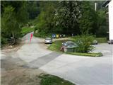
From the highway Ljubljana - Karawanke Tunnel, we take the last exit Hrušica, then turn right towards Jesenice. After a few 100 meters of driving, we come to an intersection, where we turn left uphill through the right bend. At the top of the hill another intersection awaits us, where we again choose the left direction (a signpost for Dobršnik stands here too). After a further 200 meters of driving, on the right we notice a bus stop, immediately behind it the road which branches off to the right towards the apartment blocks. Here, nearby at a suitable place, we park.
Route description:
From the parking lot (e.g. on the right near the apartment block), we continue on the road which goes straight uphill through the right turn. Already immediately at the top of the turn we notice a road which leads left among houses (street). We take it in that direction, and after 100 m (end of the street), we turn left downhill along the small hill, almost to the stream. We don't cross it, but at the last house on the right we step onto the cart track which leads into the forest (it looks like a private path).
In the forest at the junction we stick to the lower - left path, which runs along the stream. After a few minutes' walk the path crosses the stream and despite its ruin already in 20 min from the starting point we reach the first 3-level, 9 meters high waterfall, which descends somewhat diagonally down the rock face.
On the left we can now notice the path which rises towards the rocks in two small zigzags. We step onto it, and after a few steps we grab the rock beside it to climb to the top of the path leading to the second - 10 meter picturesque waterfall. Next to it on the left wall we will notice remains of torn safety gear, and steps carved into the rock (don't try to climb - wet rocks!).
We return towards the first waterfall, but before approaching it, we turn right into the steep gully or leaf-covered scree - or chute, which rises increasingly vertically. Here there is no indicated path, so it is best to carefully watch for traces of our predecessors. To the left, somewhat aside from the mentioned chute, the walking is a bit easier, so we preferably continue there. On the slope we will carefully ascend for quite some time more, avoiding wet tree roots, after which somewhat above the "chute" we will notice a fallen beech trunk. Next to it we will now more easily cross the slope to the right towards the edge of the Dobršnik stream canyon, which winds deep below us. Here on the edge (+/- a few m) we carefully choose a vantage point. We will spot the waterfall somewhat above our horizon in the northern direction. On the descent we will need some carefulness.

Photos:
 1
1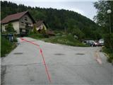 2
2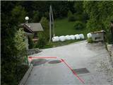 3
3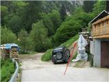 4
4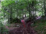 5
5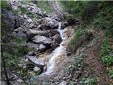 6
6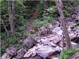 7
7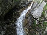 8
8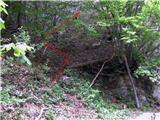 9
9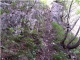 10
10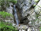 11
11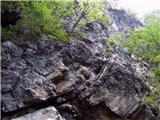 12
12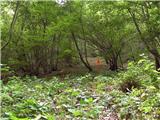 13
13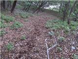 14
14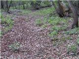 15
15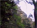 16
16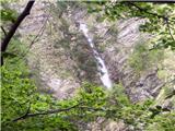 17
17
Discussion about the trip Hrušica - Dobršnik waterfalls
|
| birch22. 05. 2009 |
Excellent description, Heinz and thanks. The waterfalls are worth seeing and it's really a shame that many people, even Hruščani, don't even know about these waterfalls.
|
|
|
|
| Franc6026. 03. 2014 |
A more detailed description of the waterfalls and geological highlights is in the book by Anton Ramovš: Slapovi v Sloveniji (Slovenska matica, 1983)
How it went from the second waterfall onwards:
Here the sightseeing ends for most visitors - only the bolts without the wire rope remain from the former equipment. Climbing above the second waterfall, from where we can already see the third (8m) and fourth (11m) from its mouth, is not too difficult (II, if the rocks are dry), but a rope is almost necessary. //one must also think about the return - easier with a descent on the rope// If there is not too much water, one can probably get closer to the third waterfall along the streambed. A spot from where the fourth waterfall would be better visible could probably be found too (we had high spring water). Further on, no passage is visible, nor any remains of the former path.
Visiting the other waterfalls is pure pathless terrain, except perhaps from the seventh to the path, where with a lot of imagination we find some zigzags. The slope is quite steep, trees mostly sparse, so an ice axe comes in very handy. In any case, only experienced off-trail hikers with equipment should attempt this exploration. The description and sketch are only approximate !!!
Below the first waterfall, we cross the streambed and climb up the eastern bank (somewhere between the new landslide and the smooth slab) to the edge. Here we go a bit further up through the forest, then descend into the gorge (the spot is hard to describe exactly - when it opens a bit to the left, ice axe?!). Thus we reach the fifth waterfall (7m), immediately above it the sixth (22m) (around 800m). //From here one could probably descend along the streambed to the mouth of the fourth waterfall - during our spring visit there was too much water.//
When returning upwards, we don't go all the way along the descent direction, but at a suitable spot (terrain shows) turn more to the left (here perhaps some zigzag of the old path is noticeable). Again we descend into the gully and thus reach the seventh waterfall (9m) (around 840m). The exit is straight up - higher we encounter an almost unnoticeable (buried) path. Somewhere there we finally step onto the real, safe path (around 900m), which from Hrušica via Češnjevec leads to Rogarjev rovt. If at descent at 820m we choose the shortcut, we return exactly to the starting point.
|
|
|
|
| Franc6026. 03. 2014 |
I also have photos of all seven waterfalls and a map, but I don't know how to add them to the description.
|
|
|
|
| otiv26. 03. 2014 |
Franc60, you can add photos to the description under Current Conditions.
|
|
|
|
| Jusk7. 08. 2021 20:30:53 |
Another path or trail leads into the Dobršnik gorge, the turn-off is somewhere halfway along the path from Hrušica towards Rogarjev rov, at Tončkov stolp (miniature Aljažev stolp along the path) there is also a sign on the tree. From the turn-off to the gully is less than 5 minutes. The trail is 'marked' with dots on trees, where the slope is steep there is also a chain for grip. In this part of the gully we are already above the waterfalls, but it's still nice to explore, plenty of pools, small waterfalls.. in short, wilderness
|
|
|
To post a comment you must log in:
If you do not yet have a username, you must first
register.