Starting point: Hodoš (258 m)
| Latitude/Longitude: | 46,82763°N 16,32664°E |
| |
Walking time: 50 min
Difficulty: easy unmarked way
Elevation gain: 47 m
Elevation difference along the route: 70 m
Map: Pomurje 1:40.000
Recommended equipment (summer):
Recommended equipment (winter):
Views: 92
 | 1 person like this post |
Access to starting point:
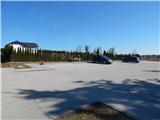
We drive to Murska Sobota, and then we follow the signs for Hodoš. When we get to Hodoš, we turn left towards the center of the settlement, where at the municipal building we turn right and past the branch primary school we drive to the nearby cemetery, where we park on a larger asphalted parking lot.
Route description:
From the parking lot, we return to the municipal building, and then we continue right, where we walk on a sidewalk, which leads us through the village. At the turn-off of the road to the right towards the settlement Glava Zale / Szalafo and the Mladinski dom Hodoš, the sidewalk ends, and we continue in the mentioned direction (straight towards Hodoško jezero). Next follows an ascent past a few more houses, above the settlement where the road splits.
We continue left on a macadam road (right towards Mladinski dom Hodoš), on which we proceed without significant changes in altitude. The road further makes some 90-degree turns, then passes into the forest, where, heading approximately north, we continue all the way to the historical Határkőpark.
Description refers to conditions in March 2024, and pictures are from various periods.
Photos:
 1
1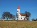 2
2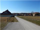 3
3 4
4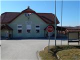 5
5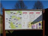 6
6 7
7 8
8 9
9 10
10 11
11 12
12 13
13 14
14 15
15 16
16 17
17 18
18 19
19 20
20 21
21 22
22 23
23
Discussion about the trip Hodoš - Határkőpark
To post a comment you must log in:
If you do not yet have a username, you must first
register.