Hibje - Koča na Dobrči (by road)
Starting point: Hibje (1000 m)
| Latitude/Longitude: | 46,3686°N 14,2447°E |
| |
Route name: by road
Walking time: 1 h 15 min
Difficulty: easy marked way
Elevation gain: 478 m
Elevation difference along the route: 478 m
Map: Karavanke - osrednji del 1:50.000
Recommended equipment (summer):
Recommended equipment (winter):
Views: 36.489
 | 2 people like this post |
Access to starting point:
From highway Ljubljana - Jesenice, at the junction Podtabor we continue in the direction of Ljubelj and Tržič. We continue driving on the fast road towards Ljubelj, and then just before the gas station, we turn right in the direction of Tržič and Begunje. The road then starts descending, and at the first crossroad, we continue left (direction Begunje) through the underpass, through which we come to Bistrica pri Tržiču. A little further, a sign for Begunje points us right on a narrower and ascending road, which we then follow through the village Brezje and Hudi Graben. After Hudi Graben, only a few 100 meters after the crossroad, where the road to the villages Leše and Paloviče branches off to the left, we will on the right side notice a macadam road and next to it signposts for Dobrča. We go on the mentioned macadam road (turn from the main road is sharply to the right) and then we follow it to altitude approx. 1000 meters, where at the smaller crossroad we notice hiking signposts and below them a parking lot.
Access from Begunje is also possible.
Route description:
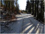
From the parking lot, we continue on the left upper and wider road (right rough road quickly ends), which soon makes a left turn, then for quite some time ascends diagonally towards the west. Higher, the road makes a sharp right turn and gradually passes into a dense forest. Further, the road makes a few zigzags, and then it brings us to a gate (to here it is possible also with a car, but the road on certain places is pretty steep and rough). We continue past the gate and continue the ascent on the road, which quickly brings us on the ridge of Dobrča. Here the road turns to the right and gradually passes on the north slopes. The road, from which some view opens up on the main chain of Karawanks, soon brings us to the mountain pasture Podgorska planina. Here we continue right and after a few minutes of additional walking, we arrive at the mountain hut Koča na Dobrči.
Photos:
 1
1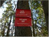 2
2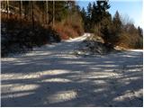 3
3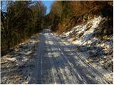 4
4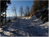 5
5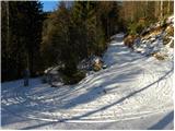 6
6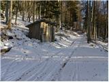 7
7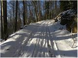 8
8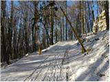 9
9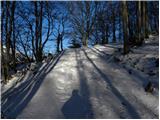 10
10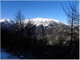 11
11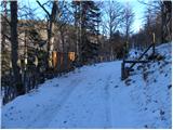 12
12 13
13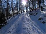 14
14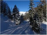 15
15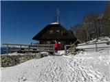 16
16
Discussion about the trip Hibje - Koča na Dobrči (by road)
|
| Gost4. 03. 2007 |
Super nice hike, especially in sunny weather! The description should say to park at the bend by the big rock, from there it's still 1 hour 15 min walk. Only there is space for two cars and from there the road is actually bad. Better to leave the car a bit lower, at the signs for hudi graben, begunje...
|
|
|
|
| JanezŽumer8. 12. 2007 |
Not by the road, if you follow the markings it's better. No stamp in the hut or they're saving it, but plenty of empty beer bottles (Zlatorog and Union). 5.12. nice outing, a bit cold, but no stamp.
|
|
|
|
| Gost11. 12. 2007 |
More and more people hiking in the mountains just to get the stamp. Best, Franc
|
|
|
|
| Gost19. 12. 2007 |
Yeah looks like the guy likes to take a little sip and everyone does it a bit, right? and everyone does it a bit, right?
|
|
|
|
| Gost20. 12. 2007 |
Some yes some no
|
|
|
|
| Gost20. 12. 2007 |
And mountain stations seem like a suitable place to you to take a sip?
|
|
|
|
| Gost24. 01. 2008 |
Was on Dobrča today and even though it's not weekend ran into the caretaker. Very friendly, got tea and a shot of schnapps then to the top and down the other side to the valley past Bistriška planina. Very nice trip. Lp Janez
|
|
|
|
| Gost29. 01. 2008 |
Franc, I see nothing wrong with collecting stamps. I think nobody goes to the mountains just for a stamp... it has no material value. I've had the booklet since age 14, and I still take it with me to the mountains. Just a memory, like photos...
Martina
|
|
|
|
| grand30. 01. 2011 |
Has anyone been to Dobrča recently? How is the road to Hibje?
|
|
|
|
| PREDO23. 04. 2012 |
I'm also interested in the road conditions or how far you can drive with a personal car?
How much further on foot to the hut below Dobrča?
Thanks in advance for the info!
|
|
|
|
| Bojan_A23. 04. 2012 |
There is snow on Dobrča now (Lada level still makes it ). Otherwise (if you don't mind your car) drive to the barrier in front of the hut. From there it's another good 5 minutes of gentle walking to Koča na Dobrči.
|
|
|
|
| hostar24. 04. 2012 |
But peace-loving hikers don't walk on foot to the mountains
Well, once we sit in front of the hut no one knows how we got there, then other things start bothering us, like music at the neighboring hut etc....
Yeah, that's us little Slovenians.
|
|
|
|
| pikica124. 04. 2012 |
Hudirja, I first thought you couldn't manage the path due to health issues, not laziness.
|
|
|
|
| pemi25. 03. 2014 |
Hi.. has anyone been on this trail to Dobrča recently? How much snow is left up there?
|
|
|
|
| pemi26. 03. 2014 |
thanks, but is the trail nicely passable.. or is there a chance to get lost somewhere 
|
|
|
|
| gorska.zvezda4. 08. 2024 15:46:27 |
The road is in very poor condition, almost impassable if you don't have a jeep. At one point, there's even a large rock on the road, which you can bypass with a smaller car. I don't recommend it.
|
|
|
|
| Martin Dercar4. 11. 2025 22:06:42 |
You can get to the hut by bike I think yes, judging by the pictures, my wife and I have already been up on foot.
|
|
|
To post a comment you must log in:
If you do not yet have a username, you must first
register.