Gozd Martuljek - Rigljica (normal approach)
Starting point: Gozd Martuljek (750 m)
| Latitude/Longitude: | 46,4821°N 13,8378°E |
| |
Route name: normal approach
Walking time: 5 h
Difficulty: rock climbing ascent
Elevation gain: 1324 m
Elevation difference along the route: 1500 m
Map: Kranjska Gora 1:30.000
Recommended equipment (summer): helmet
Recommended equipment (winter): helmet, ice axe, crampons, lamp
Views: 12.642
 | 5 people like this post |
Access to starting point:
From Mojstrana we drive towards Kranjska Gora or vice versa, but only to the village Gozd Martuljek, where we park on a parking lot near the bridge over the river Sava Dolinka (parking lot is located after the bridge, or before, if we come from Kranjska Gora).
Route description:
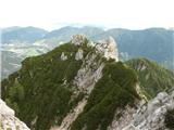
From Gozd Martuljek we go towards Kurji vrh. In the cirque below Rigljica at the boulder on which there is a sign PP we go left on the scree on the ridge between Kurji vrh and Rigljica. A walk on gravel could be very strenuous so we rather stick to the right side, on which runs a nice lane of dwarf pines. Without bigger problems we reach the ridge and from there otherwise rare cairns show the further path. Barely noticeable footpath is winding on slopes above Pišenca, and sometimes the footpath goes also into northern walls. The footpath on which we are getting closer to the upper massif soon brings us into a notch, where an easy strolling ends.
The first mountain wall is approximately 100 meters high. We climb it straight, or slightly towards the right on a visible rift (easy-I. grade), on a plain we cross to the right around 30 meters and we go into the second wall. This route also sticks more to the right, orientation point can be a rounded rock, around which runs the route. We continue through the gully, where higher on the root of dwarf pine we run into an anchor for a descent, when we will return. From the root, we ascend slightly left and in a pleasant short climbing (II. grade) we reach the ridge of the secondary peak. On the ridge, we go towards the left to an anchor for a descent. From there we descend into a rough gully approximately 15 meters. In front of us there is steeply ascending the last barrier, which is detail of the tour. 20 meters of groove we have to climb, before we can clip into an anchor on a comfortable ledge. The most difficult part is possible to bypass on the right. On a very exposed ledge and around the edge on leaned plates on the upper broken rocky slope (II. grade). But because we are principled, we are now standing on the ledge, and in front of us there is another wall, which we climb diagonally towards the right to huge rock, where there is an anchor for a descent. Now we have two options: first is on the right around the edge and on a rocky section into the upper crumbly rocky slope. The second option is for the brave: from the rock where we are standing towards the summit spans a distinct chimney. On the left flank it is completely broken so we need to climb right on an outside corner. Exposure is magnificent, rock crumbly. The chimney ends right at the top of a broken rocky slope. We are standing on a secondary peak of Rigljica, for approach to the summit, where there is an inscription box we need to descend to a crumbly outside corner, which we bypass on the right. The main problems are over, to the top there is a pitch of a crumbly slope.
Rigljica is according to many the most difficult ascent, which can still be described in the mountaineering guide books. Because of the chimney detail, it reaches good III. grade. Detail is "equipped". The terrain is unclear and orientation difficult. We return on the ascent route. Anchors for a descent are settled and accessory ropes replaced. The tour is a rock climbing ascent III/II grade by UIAA. It is mandatory to be escorted by experienced mountaineer, if possible alpinist.
Equipment on this tour is self-evident.
For reflection: tour is possible to connect also with nearby Rušica.
From Rigljica we descend back to appropriate spot, where we go towards the large boulders. Past boulders to cracks of Rušica and there through plates to the summit. Difficulties don't exceed II. grade. The tour is very wild and I strongly recommend it. For the descent from the peak of Rušica we return on the same path. Over the last spot we descend on a rope-settled descent.

Photos:
 1
1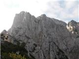 2
2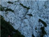 3
3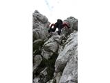 4
4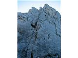 5
5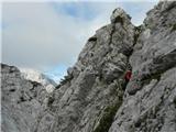 6
6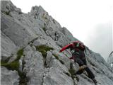 7
7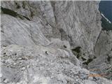 8
8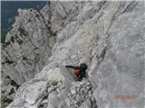 9
9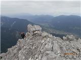 10
10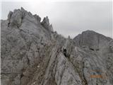 11
11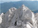 12
12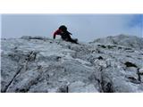 13
13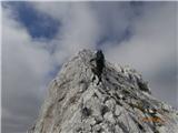 14
14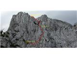 15
15 16
16
Discussion about the trip Gozd Martuljek - Rigljica (normal approach)
|
| Janez Seliškar8. 02. 2014 |
There are fewer and fewer corners where we feel such a connection with nature. I highly recommend it to those whose knowledge and psyche allow it.
|
|
|
|
| malbreht6. 09. 2014 |
At the logbook pencil is missing, let a good soul take it on next trip and leave it up there.
|
|
|
|
| 75'er6. 09. 2014 |
That shouldn't be a problem, every mountaineer should carry a pencil anyway, so someone will bring it.
|
|
|
|
| Jež si ti15. 12. 2016 |
Hello,
what equipment do you recommend, based on your experience?
|
|
|
|
| turbo16. 12. 2016 |
It's that kind of mountain where those who set out for it don't ask about equipment 
|
|
|
|
| Janez Seliškar16. 12. 2016 |
It's an alpine climb with some rappels, so we know what we need.
Currently winter conditions, which means winter gear too.
|
|
|
|
| andrej7816. 12. 2016 |
This question is really a bit funny...
|
|
|
|
| Branee16. 12. 2016 |
Small crampons... that's it
|
|
|
|
| ben16. 12. 2016 |
I don't usually comment, but already in the description the mentioned equipment is a bit strange... just helmet? Despite the alpine climb? 
|
|
|
|
| ljubitelj gora16. 12. 2016 |
that's what I think is the problem of the hribi.net website. The options are:
helmet
belay kit
ice axe
crampons
headlamp
|
|
|
|
| andrej7816. 12. 2016 |
Self-belaying Riglica?
You need everything for belaying, harness, rope (60m), pitons, cams, reverso, quickdraws, slings, karabiners... well now also winter gear...
|
|
|
|
| grega_z_brega16. 12. 2016 |
well let an experienced one lead you, since you're greener
|
|
|
|
| JusAvgustin17. 12. 2016 |
Yeah right, make a science out of it. The difficulty rating says enough about the gear, and whoever still doesn't know what to take despite the description shouldn't force their way up and better stay home!
|
|
|
|
| IgorZlodej17. 12. 2016 |
Gear alone is far from enough, knowledge, experience are also needed, not to mention mental readiness and a climbing partner who doesn't leave you in the lurch at the last moment.
|
|
|
|
| sAleska2. 08. 2018 |
Is a 40-meter rope too short for the rappels?
|
|
|
|
| Viper2. 08. 2018 |
I strongly recommend a 60-meter rope. I was on Rigljica on Tuesday and it seems to me that a shorter rope for rappels could be a problem.
|
|
|
|
| dprapr2. 08. 2018 |
Isn't there only one rappel from Rigljica, over that III?
|
|
|
|
| Viper2. 08. 2018 |
I believe it is. But it is recommended to rappel down elsewhere too. Why expose oneself so much.
|
|
|
|
| JusAvgustin2. 08. 2018 |
100% support Viper... 2x30 or 1x60. Then the descent will be much easier. Of course one can go without too, but why seek trouble if there are anchors?
|
|
|
|
| sAleska3. 08. 2018 |
Once again, many thanks to everyone. I'm really glad that one gets reliable first-hand information so quickly.
|
|
|
|
| slavkoa29. 10. 2019 |
On Sunday, Mirjam and I tackled this summit, starting at Jasna and gradually conquering Kurji vrh at dawn. Despite minor health issues, we set off along the less visible path towards the initial notch. We climb the first wall slightly to the right and then a bit to the left to the upper low pines. Here we descend into the gully and spot the last difficult part of the ascent - a chimney that leads us to a larger rock with an anchor point. From there along the chimney to the scree and we're already at the fore-summit. We also find the summit logbox, but couldn't sign it as the logbook is in very poor condition. We take a little look around the ridge towards Rušica, which will be our goal together with Vrh nad Rudo on the next visit to these parts. The wonderful weather allows us some more photos and then we head back the same way. Of course, we used all the anchors for abseiling and safely descended the path towards Kurji vrh and to the starting point at Jasna. The tour is quite demanding, especially when we tackle the remaining three summits with descent from Frdamane police to Kačji graben. But that's next year.
|
|
|
To post a comment you must log in:
If you do not yet have a username, you must first
register.