Gozd Martuljek - Lower Martuljek Waterfall
Starting point: Gozd Martuljek (750 m)
| Latitude/Longitude: | 46,4821°N 13,8378°E |
| |
Walking time: 30 min
Difficulty: easy marked way
Elevation gain: 100 m
Elevation difference along the route: 100 m
Map: Kranjska Gora 1:30.000
Recommended equipment (summer): helmet
Recommended equipment (winter): helmet, ice axe, crampons
Views: 68.236
 | 4 people like this post |
Access to starting point:
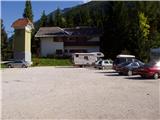
From Mojstrana we drive towards Kranjska Gora or vice versa, but only to the village Gozd Martuljek, where we park on a parking lot near the bridge over the river Sava Dolinka (parking lot is located after the bridge, or before, if we come from Kranjska Gora).
Route description:
From the parking lot, we continue by the main road towards Kranjska Gora, but only to a spot where the cycling road branches off to the left (by the beginning of the cycling path there are also signposts, which point us to the mentioned road). We follow the cycling road to the first crossroad, where we continue straight on a macadam road (cycling road turns right), which quickly brings us to the next crossroad.
We continue right and follow the road closed to traffic to the TNP sign. Further, the path splits into two parts. We take the left path, which brings us to a small bridge which crosses the river. Immediately after the small bridge, we turn right into the gorge of the Martuljek waterfalls. The path ahead is exposed to falling stones so it is best to put on helmets. The path ahead first gently ascends along the river uphill, then with the help of stairs starts to ascend more steeply. The path then crosses a bigger bridge over the river and on the other side ascends stairs below the wall. Only a few steps ahead, the path brings us to another bridge, from which there is a nice view of the Spodnji Martuljkov slap.

Photos:
 1
1 2
2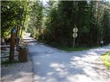 3
3 4
4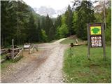 5
5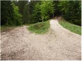 6
6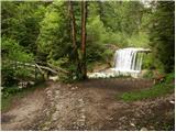 7
7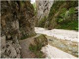 8
8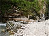 9
9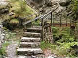 10
10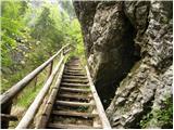 11
11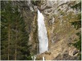 12
12
Discussion about the trip Gozd Martuljek - Lower Martuljek Waterfall
|
| Gost5. 06. 2006 |
Super trip, if you don't have too much time, but still want to admire the beauties of TNP. Of course, if you're already going to the lower Martuljkov Slap, go to the upper one too, which is personally even more beautiful than the lower one for me. At the upper one, don't push all the way to the waterfall if you're not confident in the "rock".
|
|
|
|
| Gost5. 05. 2007 |
Is it worth visiting the waterfalls these days? How much water is there? Thanks
|
|
|
|
| Gost5. 05. 2007 |
I think it's quite appropriate since snow is melting above the waterfalls.
|
|
|
|
| Gost23. 12. 2007 |
Does this waterfall freeze in winter? I'm interested because my buddy and I made a bet. Peter
|
|
|
|
| 5ko29. 09. 2011 |
The path to the lower waterfall is closed, so at the TNP sign it sends you along the path to the upper waterfall and then you descend along the arranged marked path to the waterfall (according to the sign the descent should be very demanding - but it's not - it's arranged with wooden railings, steps and in between with a rope instead of railing). This path at least is not exposed to falling rocks. Did the path with a two-month-old child (in a carrier) and with the dog.
|
|
|
|
| damjanindamjana16. 07. 2013 |
Does anyone have information if the lower waterfall is already open and the path repaired?
|
|
|
|
| Gost16. 07. 2013 |
The path has been repaired, nets for falling rocks have been installed, bridges are new and wider. However, the information boards state that passage is at your own risk.
|
|
|
|
| serajko16. 07. 2013 |
Hi, on 12.7.13 the lower path was officially closed. But it is safely passable at your own risk. Emergency footbridges have been installed for crossing the stream.
|
|
|
|
| orel98115. 05. 2014 |
Has anyone been to the lower waterfall recently, is the path passable?
|
|
|
|
| slavi090215. 05. 2014 |
@orel981.....we were there on 12.4. it was normally passable then, even though the sign saying the path is officially closed has been up for quite some time, we all know we go at our own risk....but it's worth visiting the upper one too, because this year both have a huge amount of water and are magnificent
|
|
|
|
| plaNinaPirsMajcen10. 05. 2025 10:05:15 |
https://youtu.be/1_R0daPDEeE?si=l69tp1bnnJJPQbEw
Nice idea for a family outing.
Recorded on 2.5.2025
Lower and upper Martuljek waterfall and gorge with stream, rapids in between, cute stone men along the riverbed, pleasant splash of water droplets along the path, fantastic views of the surrounding mountains... all this does not leave the mountaineer indifferent 🤩
On the ascent, we chose the path along the river to the lower waterfall and past Ingotova koča on planina Jesenje to the upper one.
On the way back, we went along the forest road, bypassed planina Jesenje and the lower Martuljek waterfall.
Best, Nina
|
|
|
To post a comment you must log in:
If you do not yet have a username, you must first
register.