Gozd Martuljek - Bivak pod Špikom (along the river)
Starting point: Gozd Martuljek (750 m)
| Latitude/Longitude: | 46,4821°N 13,8378°E |
| |
Route name: along the river
Walking time: 2 h
Difficulty: easy marked way
Elevation gain: 674 m
Elevation difference along the route: 675 m
Map: Kranjska Gora 1:30.000
Recommended equipment (summer): helmet
Recommended equipment (winter): helmet, ice axe, crampons
Views: 23.112
 | 3 people like this post |
Access to starting point:
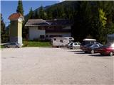
From Mojstrana we drive towards Kranjska Gora or vice versa, but only to the village Gozd Martuljek, where we park on a parking lot near the bridge over the river Sava Dolinka (parking lot is located after the bridge, or before, if we come from Kranjska Gora).
Route description:
From the parking lot, we continue by the main road towards Kranjska Gora, but only to a spot where a cycling road branches off to the left (by the beginning of the cycling path there are also signposts, which point us to the mentioned road). We follow the cycling road to the first crossroad, where we continue straight on a macadam road (cycling road turns right), which quickly brings us to the next crossroad.
We continue right and follow the road closed to traffic to the TNP sign. Further, the path splits into two parts. We go on the left path, which brings us to a small bridge which crosses the river. Immediately after the small bridge, we turn right into the gorge of Martuljek waterfalls. The path ahead is exposed to falling stones so it is best to put on a helmet. The path ahead first ascends gently by the river upwards, then with the help of stairs starts to ascend steeper. After that, the path crosses a bigger bridge over the river and on the other side ascends stairs below the wall. Only a few steps ahead, the path brings us to another bridge, from which there is a nice view on Spodnji Martuljkov slap.
After the bridge, the path turns left and ascends below the steep slopes near the waterfall. Further, we continue right on wet ground almost horizontally. The path ahead then ascends steeper and after a shorter ascent brings us to a cart track, where we continue left (here we join the path which bypasses the gorge). Already after a few steps, the path brings us to a junction, where the path to the bivouac Bivak pod Špikom branches off to the right (straight to Zgornji Martuljkov slap). We take this path, which first ascends gently on a cart track. When the path approaches a torrent we encounter an orientation loop. The path left leads to the torrent and then disappears, we continue straight past a smaller boulder on which there is a trail blaze. After that our path also approaches the torrent but does not cross it yet. Further it ascends on the right side and crosses it a little later. The crossing is not difficult, but the ascent from the torrent back to the path is somewhat harder. This part is only three meters long so it does not cause us problems. The path ahead ascends gently through the forest to the next torrent at which stands a boulder with a large blaze. The path ahead starts to ascend steeply on a forest-covered slope. In the middle of this ascent we encounter a small spring and a little further a pleasant bench. Further the forest becomes sparser and the path brings us to unvegetated slopes below Špik, where we encounter torrent deposits of stones. The path here turns slightly right and goes back into the forest. After a few minutes of moderate ascent from the torrent deposits we arrive at the bivouac Bivak pod Špikom.

The trip can be extended to the following destinations: Rigljica (3 h)
Photos:
 1
1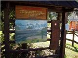 2
2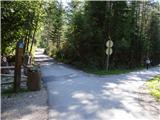 3
3 4
4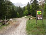 5
5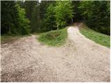 6
6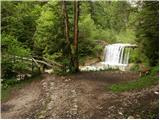 7
7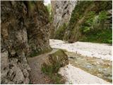 8
8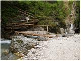 9
9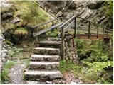 10
10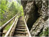 11
11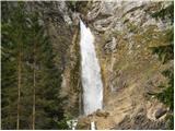 12
12 13
13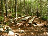 14
14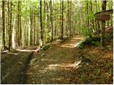 15
15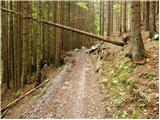 16
16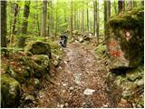 17
17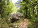 18
18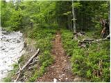 19
19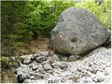 20
20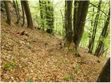 21
21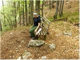 22
22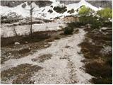 23
23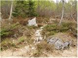 24
24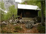 25
25
Discussion about the trip Gozd Martuljek - Bivak pod Špikom (along the river)
|
| klinchy14. 11. 2012 |
This is not worth being called a Bivouac.....
|
|
|
|
| plavžar14. 11. 2012 |
Please explain why it is not worth being called a Bivouac!
|
|
|
|
| potočan14. 11. 2012 |
This is one of the best bivouacs in the Julian Alps.
|
|
|
|
| klinchy4. 03. 2013 |
I don't know why the lower part of the bivouac is not open?
The upper part is very dirty and everything smells...
I've visited quite a few bivouacs and this one is in the worst condition so far.
|
|
|
|
| Jonny_20. 07. 2015 |
The path is officially closed due to renovation until further notice.
|
|
|
|
| MountaineerX15. 11. 2017 |
Today - Lower waterfall nicely passable, snow around 5 cm. Slippery due to leaves. More snow around 1000 m a.s.l. From 30 cm up to 70 cm. We didn't finish the path because of the dog, as it was wallowing in the snow.  We made a track to the upper bench. Ice axe and basic crampons suffice... Good luck and LP We made a track to the upper bench. Ice axe and basic crampons suffice... Good luck and LP 
|
|
|
|
| michael6613. 09. 2018 |
Hmmm, I really don't know where the difference in elevations on this path comes from
|
|
|
|
| Tadej13. 09. 2018 |
Thanks for the warning. I have corrected it.
|
|
|
To post a comment you must log in:
If you do not yet have a username, you must first
register.