Gostišče Firšt - Govca (Olševa)
Starting point: Gostišče Firšt (677 m)
| Latitude/Longitude: | 46,4217°N 14,668°E |
| |
Walking time: 3 h 45 min
Difficulty: partly demanding marked way
Elevation gain: 1252 m
Elevation difference along the route: 1252 m
Map: Kamniške in Savinjske Alpe 1:50.000
Recommended equipment (summer): helmet, lamp
Recommended equipment (winter): helmet, ice axe, crampons, lamp
Views: 21.052
 | 2 people like this post |
Access to starting point:
On the road from Radmirje or over Kranjski rak towards Logarska dolina, about a kilometer further from Solčava, we stop at the inn Firšt. It is good to ask someone about parking. In the inn there is an interesting museum about Potočka zijalka. We can also park to the right 200 m higher in the forest at the end of the macadam road.
Route description:
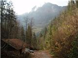
From the inn Firšt to the farm Rogar the path leads us along a forest cart track. A kilometer above Firšt, this cart track splits to the left and straight ahead. The correct path is to the left. Higher up, we reach a smaller clearing with some old buildings. The path then leads us again for a short time through the forest. In the upper part of the meadows at Sveti duh we cross a panoramic road and continue towards the farm Rogar, from which we then continue left along a cart track that begins to ascend through the forest. The cart track soon turns into a footpath that brings us to the state border with Austria. The path then runs along the border and brings us to a junction. The left path leads to Austria, but we head right following the signs to Potočka Zijalka. From the junction there follows only another 10 minutes of steep ascent and we are already at the karst cave named Potočka Zijalka.
The path then starts ascending again and brings us to the next junction. The left path leads to Obel kamen (1911 m), but we head right onto the path to Govca, the highest peak of Olševa. There follows a traverse of steep slopes below Olševa. This part of the path is somewhat exposed, and some fixed safety gear assists us. The path then turns left, where the path over Obel kamen joins, and to the summit there follow only a few minutes of steep ascent.
For the descent, we can go over Obel kamen. The path therefore is not much longer but is panoramatally much more beautiful.

Along the route: Gostišče Firšt (677m), Sveti duh (1232m), Koča pod Olševo (1232m), Kmetija Rogar (1240m), Potočka zijalka (1700m)
Photos:
 1
1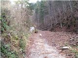 2
2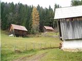 3
3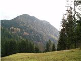 4
4 5
5 6
6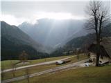 7
7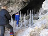 8
8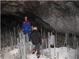 9
9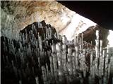 10
10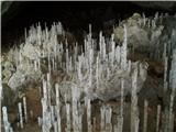 11
11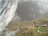 12
12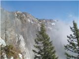 13
13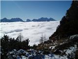 14
14 15
15 16
16 17
17 18
18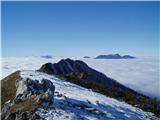 19
19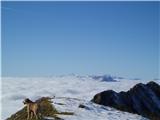 20
20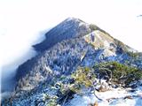 21
21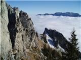 22
22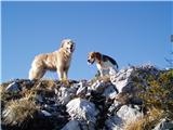 23
23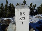 24
24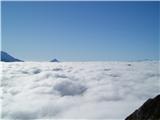 25
25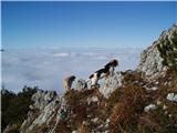 26
26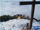 27
27 28
28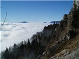 29
29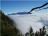 30
30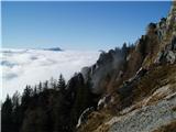 31
31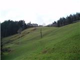 32
32
Discussion about the trip Gostišče Firšt - Govca (Olševa)
|
| yelly27. 07. 2009 |
We ascended Govca on 26.7.09. The day was wonderful, view from the top fantastic, but the trail quite strenuous. However, the 2h length info is probably not correct as we walked from Gostišče Firšt almost twice as long (just under 4)!
Correct the walking time on the trail description urgently!
|
|
|
|
| bandy27. 07. 2009 |
it says 3h and 45 min 
|
|
|
|
| Tadej27. 07. 2009 |
The time was corrected after Yelly's post.
|
|
|
|
| JTrogar29. 07. 2009 |
I really hiked to Govca in exactly 1h 53min. Proof are the photos. With the family, we took more than 3h just from Sv. Duh. Alone, I need 1h 55min to Ojstrica from the mountain hut via Kopinškova and back to Škarje, etc. I certainly agree with the time correction, as we are not all always in the same good condition. My suggestion is the option to enter time from-to. I wanted to enter 2-5h, but that's not possible. Then everyone can determine their approximate time based on their abilities. After all, everyone who hikes more in the mountains notices how differently the times on markers are timed and deceptive in the mountains. From-to would mean from for those in good shape, to for those in poorer shape, of course for recreational hikers. Worth thinking about. Best regards from under the beautiful Mozirska planina, Janez.
|
|
|
|
| geppo29. 07. 2009 |
But even to get from Planinski dom - Klemenca - Kopinškova - Ojstrica summit - and back to Škarje 1h 55min
hats off for that time - then you're really fast!!!!!
I did it in five hours (when I was young) and thought I was "Superman"
check again?
Best,
|
|
|
|
| geppo29. 07. 2009 |
I didn't mean just Škarje, but the starting point - PLANINSKI DOM
Best,
|
|
|
|
| JTrogar29. 07. 2009 |
Pardon, 1h 55min to the summit. For the whole tour with all stops 3h 40min. That's already acceptable, right? Best, Janez.
|
|
|
|
| Kriška30. 07. 2009 |
These walking times are really a cross . Of course all estimates are at least somewhat subjective, so we can probably find quite a few different data for the same path (hiking guide one, signs along the path another - sometimes even signs along the path within cca 5 min. walk show that you've already walked half an hour, or vice versa - you walk half an hour, arrive at the next sign where you realize you stood still, another different data can be on these pages). . Of course all estimates are at least somewhat subjective, so we can probably find quite a few different data for the same path (hiking guide one, signs along the path another - sometimes even signs along the path within cca 5 min. walk show that you've already walked half an hour, or vice versa - you walk half an hour, arrive at the next sign where you realize you stood still, another different data can be on these pages).
What if we agreed on a consensus that applied "in the good old days", i.e.: basis - 300 m elevation gain = 1 hour walk, with eventual correction also regarding distance in km?
If we knew that all descriptions of walking times are based on this basis, everyone could recalculate based on terrain experiences how much time they themselves would need.
|
|
|
|
| pavaonurmi25. 05. 2010 |
This jtrogar is quite a guy. Today I went from Firšt to Govca, times don't matter at all, but it's interesting that someone completes this tour in 1h 53min, and from the Planinci home to Ojstrica only 2 minutes more. Let's leave the elevations and path difficulty aside...  lp lp
|
|
|
|
| franjo6615. 05. 2014 |
What are the conditions like?
|
|
|
|
| lakkon23. 10. 2015 |
in the path description it says:
''... about a kilometer further from Solčava we stop at Gostišče Firšt. It's good to ask someone for parking...''
is it usually possible to find (free?) parking in the valley along the Savinja on weekends? right there around the guesthouse or max a kilometer towards Logarska dolina or Solčava?
|
|
|
|
| Tbs23. 06. 2024 19:40:04 |
What is this trail like today? How are the fixed protections? The description is a bit skimpy. Is it marked?
|
|
|
|
| turbo23. 06. 2024 20:09:03 |
In the data it says:
Difficulty: partially demanding marked trail
But in the description:
This part of the trail is somewhat exposed, some fixed protections help us.

|
|
|
To post a comment you must log in:
If you do not yet have a username, you must first
register.