Starting point: Gabrče (575 m)
| Latitude/Longitude: | 45,7094°N 14,0111°E |
| |
Walking time: 2 h
Difficulty: easy marked way
Elevation gain: 452 m
Elevation difference along the route: 500 m
Map:
Recommended equipment (summer):
Recommended equipment (winter):
Views: 31.334
 | 1 person like this post |
Access to starting point:
From the highway Ljubljana - Koper we go to the exit Senožeče. When we leave the highway, at the first crossroad we continue left in the direction of Senožeče. In Senožeče, we turn right in the direction of Divače and follow the road ahead to the spot, where the road branches off to the left into the village Gabrče. We follow this road through the village and we park on a smaller parking lot right next to a smaller crossroad, which is situated after the village.
Route description:
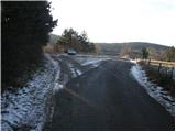
From the parking lot, we continue on the left worse (marked) road which after a few minutes of walking starts moderately ascending. After a short ascent, we join the other wide macadam road which we follow left. This road quickly brings us to a crossroad, where we notice the first signs. Here we continue left upwards on the road which soon comes out of the forest on panoramic slopes. At an altitude of 800m, near the mountain signposts, we leave the road and we go right on a footpath which crosses a shorter lane of a pine forest. The path then passes on extensive grassy slopes of Vremščica, which offer nice views. The path ahead occasionally crosses some shorter lane of forest but quickly leaves it. We mostly follow the path which ascends only gently in the southeastern direction. After some time from the right, the path from the Škocjan Caves joins and only a little further from the left the path from Senožeče. After both crossings, the path for a short time ascends and after 15 minutes of ascent on the upper ridge, it brings us to the summit of Vremščica.

Photos:
 1
1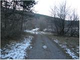 2
2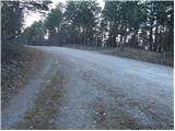 3
3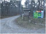 4
4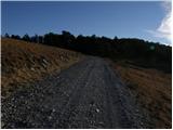 5
5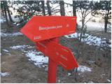 6
6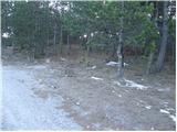 7
7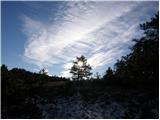 8
8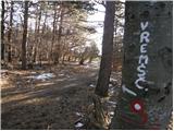 9
9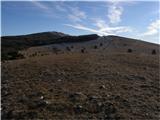 10
10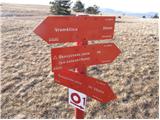 11
11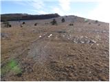 12
12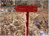 13
13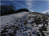 14
14 15
15
Discussion about the trip Gabrče - Vremščica
|
| Benč17. 02. 2008 |
Nice effortless Sunday walk despite slightly windy weather.
In spring up again when everything blooms 
|
|
|
|
| Biser gora28. 02. 2008 |
Just watch out not to pick windy weather. When we were on Vremščica last year, the strong gale almost blew us away.
|
|
|
|
| sijoze7. 12. 2008 |
Very nice Sunday trip. Vremščica offered a fantastic view today. Low hill but we saw half of Slovenia or even more. We went further from the signs along the road past the sheep farm until we reached the path coming from Škocjan Caves going left up the hill (a bit of attention). At 800m it joins the path coming by road. Rest is the same.
|
|
|
|
| frankosusa16. 10. 2011 |
 those stupid guys marked that at the end of Gabrče there is parking those stupid guys marked that at the end of Gabrče there is parking
|
|
|
|
| B21. 11. 2011 |
The path (marked) is part of VIA ALPINA, specifically Senožeče - Škocjan Caves. Parking in Gabrče village is still marked from the times when the inn was operating here... Instead of in Gabrče, we can also park at the intersection of gravel roads Senožeče - Vreme at the junction for Vremščica (photos 3 and 4). We get there by driving 500m further on the main road from Gabrče, where there is a well-marked left turn onto the gravel road. From here, we go left uphill on the unmarked gravel road and in about 40 minutes reach a scenic clearing where the SPP from Škocjan Caves joins from the right (photo 6). At the signs, go right and continue to the summit as described.
|
|
|
|
| natasja27. 03. 2017 |
At the location shown in picture 4, some confusion can arise, namely the markings direct us straight along the macadam road past the sheep farm and soon the markings run out.
Instead of straight ahead, as stated in the instructions, head to the path leading left from the signs (at the spot where the left sign is, there is now a sign for the Veterinary Faculty and refreshment stand), but there are no markings until the location shown in picture 6.
|
|
|
|
| B218. 06. 2017 |
As I already wrote in 2011, the description of the hiking path Gabrče - Vremščica is completely wrong. There is no direct marked path from the village Gabrče to Vremščica!
If we want to start in the village Gabrče, we go along the marked cart track to the place in picture 4 (road junction, the place is called "Na gavgah", there are also hiking signposts, but none shows the direction to Vremščica) and then left uphill on the gravel road (no marks from here, because this is not a hiking path) until after about 40 minutes we reach the place in picture 6 and from there on the marked hiking path to the summit.
|
|
|
To post a comment you must log in:
If you do not yet have a username, you must first
register.