Drežniške Ravne - Krasji vrh (via snežna jama)
Starting point: Drežniške Ravne (820 m)
| Latitude/Longitude: | 46,2729°N 13,6147°E |
| |
Route name: via snežna jama
Walking time: 3 h
Difficulty: easy marked way
Elevation gain: 953 m
Elevation difference along the route: 953 m
Map: Julijske Alpe - zahodni del 1:50.000
Recommended equipment (summer):
Recommended equipment (winter): ice axe, crampons
Views: 54.477
 | 7 people like this post |
Access to starting point:
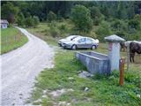
From Tolmin or Bovec we drive to Kobarid, from there we follow the road in the direction of Drežnica (the turn-off is from the Kobarid bypass). We continue over the bridge over the river Soča and immediately after the bridge we turn left in the direction of Drežnica. In Drežnica we come to the crossroads, where the road to the village Magozd branches off to the left, and we continue a little further to the next crossroads, where we turn left in the direction of Drežniške Ravne. The road then brings us to a crossroads in Drežniške Ravne, where we turn right upward in the direction of Krasji vrh. At the next crossroads, we again turn right and follow the road to a trough with water, where the asphalt ends. Here is a smaller parking lot, where we park.
Route description:
From the parking lot, we continue on a macadam road which has some shortcuts. If we continue on the road, we will after approximately an hour of walking on the left side of the road at the right turn notice signs for Krasji vrh. If we go on a footpath we don't notice these signs because the footpath on this part doesn't cross the road (it is 15 meters away). The path then ascends on a cart track and soon after that joins the path from the mountain pasture Zaprikraj. The path is then moderately ascending on slopes vegetated with forest. The path ahead crosses a clearing on which high grass grows and then again ascends to a junction at an altitude of 1450m.
We continue right in the direction of Snežna jama cave (left Krasji vrh past Koluji). The path ahead is at first ascending gently through the forest and a little higher runs over less vegetated slopes, where it brings us to a junction. We continue straight, left five minutes downwards Snežna jama cave. The path then ascends a little steeper and brings us to the ruins of World War. Left below us in a hollow we notice a bigger metal cage in which unexploded bombs are stored. After that, the path passes on a ridge, where a nice view opens up on Bovška kotlina basin and surrounding peaks. Next follows a little less than ten minutes of walking on the undemanding upper ridge.

Photos:
 1
1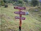 2
2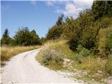 3
3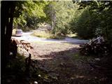 4
4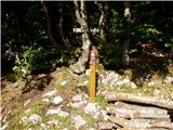 5
5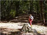 6
6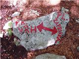 7
7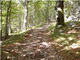 8
8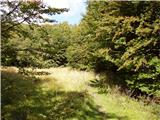 9
9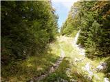 10
10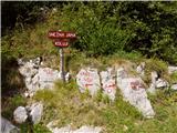 11
11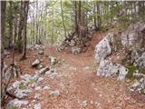 12
12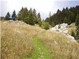 13
13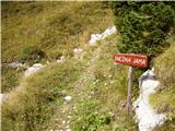 14
14 15
15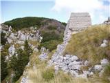 16
16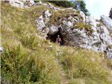 17
17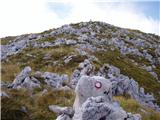 18
18 19
19
Discussion about the trip Drežniške Ravne - Krasji vrh (via snežna jama)
|
| ksena24. 03. 2010 |
Don't go to Krasji vrh without skis or snowshoes... the path is not trodden. At the start of the snow line you can walk almost normally, later it sinks deeply. Snow-free up to an altitude of about 1300m.
|
|
|
|
| mizuno12. 08. 2010 |
The last part of the path to Krasji vrh is steep but when you reach the top there is a very nice view of Kobarid, Bovec and the other mountains.
|
|
|
|
| grega_p16. 11. 2010 |
Currently snow-free up to 1400m, higher up snow accumulates quickly. On the top up to 50cm of snow and it sinks in deeply, given temperatures above zero..
|
|
|
|
| pepč16. 11. 2010 |
Last year I was there, and I'm curious what the sign "KOLUJI" means?
|
|
|
|
| IgorZlodej16. 11. 2010 |
Artillery positions on the southern side of Krasji vrh, I think there are two. A path passes by them.
|
|
|
|
| BT8818. 11. 2010 |
I'd ask since I haven't been in summer if there are orientation issues or if the path is trodden in snow? Thanks
|
|
|
|
| IgorZlodej18. 11. 2010 |
Usually no special tracks (except St. Nicholas hike, this year Dec 4), occasionally someone goes by, if enough snow most go on skis. Orientation in good weather no problem, in fog it can be quite tricky.
|
|
|
|
| pepč19. 11. 2010 |
Igor, Matjaž, thanks for the explanation and photos. If I guess right, »koluji« are wheels or circles remnants of anti-aircraft defense foundations of the Italian army on the Soča front, expressed in old local dialect, which is a real specialty in these parts, as some still go »s talalujkom dou wun«.
|
|
|
|
| Majdag30. 05. 2011 |
Krasji vrh, yesterday...
high above us, the view of Krn and the Krnčnice ridge accompanies us the whole way. On planina Zaprikaj they had just brought the livestock, it was a bit confused. Along the path itself there are numerous bunkers and various war remains.
At the top there are wonderful vistas, in the valley deep below us the Soča river winds. Views for the soul and the eye. We also inspected the koluja. The drive to Drežniške Ravne was a bit long, but it was very nice, hi Majda
|
|
|
|
| valerija1121. 08. 2014 |
Hello! In the coming days we're heading to Krasji vrh. I'm interested if the paths (direct and via pastures) are marked. I really have a map that's a couple of years old, and on it they are not drawn as marked. Thanks to those who know for the answer.
|
|
|
|
| IgorZlodej1. 08. 2014 |
From the photos above, it's clearly visible that the paths are marked and signposted with signs. I have maps that are 20 years old or more, and everything is marked 
|
|
|
|
| irska1. 08. 2014 |
Beautiful trip, recommended! Paths are really nicely marked, checked today .
|
|
|
|
| valerija1122. 08. 2014 |
Great thanks, we're going tomorrow. Looking forward to it already.
|
|
|
|
| valerija1123. 08. 2014 |
Well, we're back. Beautiful tour, and the weather served us well too. Up through the pastures, circular over the summit and directly back to the car. Praise to the trail markers and maintainers.
|
|
|
|
| damijanp21. 08. 2014 |
On my map (1996 edition) the path from the pasture is marked, but not the direct one. However, both beautiful paths are very well marked, so there are no problems at all regarding this.
Photos:
Krasji vrh
|
|
|
|
| daisy6610. 02. 2015 |
Has anyone been to the summit recently? What are the conditions? thanks
|
|
|
|
| ksena10. 02. 2015 |
Krasji vrh is above the snow line blown bare, which doesn't mean that the path to the summit is normally passable. From experience, I would venture to predict that there are sections on the path with wind-packed snow and drifts, which are the result of the strong wind last week.
|
|
|
|
| daisy6611. 02. 2015 |
Ksena thanks, I'll probably try, I can always turn back
|
|
|
|
| ksena11. 02. 2015 |
daisy66, I believe you'll make it, as the path on such terrain allows detours - you don't go through the valley, but bypass a bit up the slope. Correcting my previous entry ... above the forest line, not above the snow line 
|
|
|
|
| daisy6613. 02. 2015 |
ksena thanks for the advice, I'll try tomorrow
|
|
|
|
| SuzanaM13. 02. 2015 |
Daiys66, clouds, rain and possibly snow are forecast for tomorrow. Wait for sunshine so that Krasji vrh is really beautiful.
Last time I was on Krasji vrh on 26.1.2015. Detailed report on the forum:
http://www.hribi.net/trenutnerazmere.asp?slo=1&gorovjeid=1&id=2598&stran=4
Some descriptions of more winter ascents in older posts.
Even when the southern slopes of Krasji vrh are completely dry, conditions on the path past Snežna jama can be fully wintery. So mountaineering crampons and ice axe are usually not superfluous equipment.
|
|
|
|
| daisy6627. 02. 2015 |
SuzanaM thanks for the reply, we went anyway, only reached Planina Zaprikraj. When it's sunny it must be really nice. I'm thinking of trying it once more.
|
|
|
|
| PUHIPUHI8. 04. 2018 |
Since I don't know this peak yet, I'm interested in what this path is like in winter? Safe? Current conditions? Required equipment?
|
|
|
|
| ksena9. 04. 2018 |
The path to Krasji vrh is clear up to the Zaprikaj pasture, higher up, especially on the S side, it is still snowy.
|
|
|
|
| KarmenT20. 05. 2020 |
Is there still any snow on this path?
|
|
|
|
| darinka415. 12. 2021 16:42:46 |
I would almost dare to claim that in winter conditions the path to the summit is somewhat longer. Perhaps also because the vehicle has to be left a bit lower. At least yesterday the road to the basin was icy on a couple of bends. And as a curiosity, yesterday we looked at where the path turns off, now it is snowy at Debeljak. Neighboring peak. From what I have heard there are two peaks with this name. One is above Krn Lake. I knew about that one. But not this one.
|
|
|
|
| darinka422. 04. 2023 21:19:02 |
Krasji vrh today from Drežniške Ravne quite visited. Snow melting. There's still some on the path. On descent we decide for ascent to neighboring Debeljak.
|
|
|
|
| mikkeni27. 01. 2024 17:42:19 |
Has anyone been to Krasji vrh recently…?
|
|
|
|
| darinka48. 12. 2025 15:54:02 |
Yesterday, during the St. Nicholas hike, it was possible to make a circular tour. Winter gear was not needed because the trail was trodden.
|
|
|
To post a comment you must log in:
If you do not yet have a username, you must first
register.