Dragomer - Liparjev grič (direct way)
Starting point: Dragomer (297 m)
| Latitude/Longitude: | 46,0181°N 14,3868°E |
| |
Route name: direct way
Walking time: 15 min
Difficulty: easy marked way
Elevation gain: 77 m
Elevation difference along the route: 77 m
Map: Ljubljana - okolica 1:50.000
Recommended equipment (summer):
Recommended equipment (winter):
Views: 524
 | 1 person like this post |
Access to starting point:
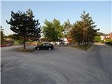
From the highway Ljubljana - Koper, we head to the Brezovica exit, then continue driving on the parallel old road towards Vrhnika. After 4.5 km of driving from the point when we got onto the old road, at the traffic-light intersection we turn right towards the center of Dragomer. Already as soon as we drove off the main road, a marked path branches off to the right, initially a road towards Debeli hrib. We park somewhere in Dragomer, best near the sports field.
Route description:
The path first leads along the asphalt road, from which a nice view opens up on Dragomer. The asphalt soon ends, and the road passes into the forest, where we need to pay attention to the branch-off of the marked mountain path to the right. The marked path first ascends relatively steeply, then passes onto the ridge of Liparjev grič to a junction, where the path from Lukovica pri Brezovici joins us.
At the junction there are signposts for Pentlja.
We continue left and when the path passes from the forest onto a meadow, we turn right onto pathless terrain and in a few steps we are on the grassy summit of Liparjev grič.
The description refers to the condition in May 2021.
Photos:
 1
1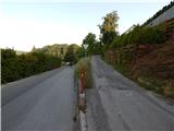 2
2 3
3 4
4 5
5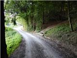 6
6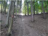 7
7 8
8 9
9 10
10 11
11 12
12 13
13 14
14
Discussion about the trip Dragomer - Liparjev grič (direct way)
To post a comment you must log in:
If you do not yet have a username, you must first
register.