Dom v Iškem Vintgarju - Iški Vintgar (Vrbica)
Starting point: Dom v Iškem Vintgarju (360 m)
| Latitude/Longitude: | 45,91180°N 14,49930°E |
| |
Walking time: 1 h 15 min
Difficulty: partly demanding marked way
Elevation gain: 60 m
Elevation difference along the route: 200 m
Map: Ljubljana - okolica 1:50.000
Recommended equipment (summer):
Recommended equipment (winter): ice axe, crampons
Views: 83.468
 | 3 people like this post |
Access to starting point:
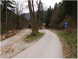
We drive onto the southern Ljubljana bypass and head to the Ig exit. At the crossroads, we then follow the directions towards Ig. At Ig, we continue towards Iška vas (we can also reach here from Podpeč or Škofljica). We then follow the well-marked road to a large parking lot near the Dom v Iškem Vintgarju hut.
Route description:
From the parking lot, we continue on the road ahead and after a few steps it brings us to the Dom v Iškem Vintgarju hut. Further, we continue on the road closed to traffic, that runs parallel with the river Iška. After a few minutes of walking, we come to a bridge over Iška. Here we leave the wide walking path and go left over the bridge, after which the path goes into the forest and ascends for a short time. Next follows a light descent on a slightly exposed ledge, on which there is a danger of slipping when wet. Further, the path flattens and crosses a clearing, after which the path soon brings us to Iška (to here we can also come on the right side but at the end there is a passage through the water). The path ahead turns a little to the left and starts ascending. Next follows a few shorter descents and ascents to a somewhat more demanding but secured passage, after which we come to a steep rocky pillar, which is like a sort of peak of the Iški Vintgar gorge. The path ahead again starts descending and brings us to Votli kamen, which is only a minute from the path. Further, the path passes out of the forest onto steep but well-secured slopes. The path then again ascends and then, in the middle of the descent, brings us to a path junction, where we continue on the right lower path, which in a few minutes brings us to the confluence of Zala and Iška. Here we notice a rocky pillar to which a path leads that crosses the water twice over a narrow bridge.

Along the route: Votli kamen (410m)
Photos:
 1
1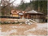 2
2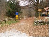 3
3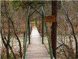 4
4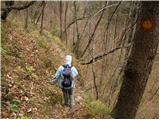 5
5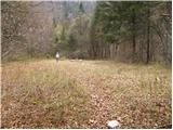 6
6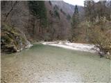 7
7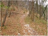 8
8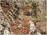 9
9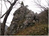 10
10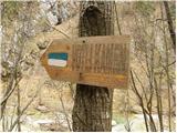 11
11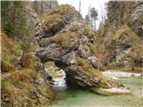 12
12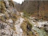 13
13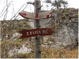 14
14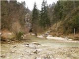 15
15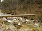 16
16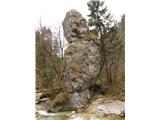 17
17
Discussion about the trip Dom v Iškem Vintgarju - Iški Vintgar (Vrbica)
|
| andrej jerina15. 11. 2008 |
Nothing to add to the path description. Despite the gloomy and cold afternoon, it was a nice family trip along the Iška River. We admired the pools, enjoyed the fresh air. Definitely suitable family trip for the youngest. LP Andrej
|
|
|
|
| Biser gora19. 01. 2009 |
On Saturday we went to Iški Vintgar with the family. It was nice, the walking path was also well trodden. Next time, when conditions are better, to the confluence.
|
|
|
|
| erikaleon24. 11. 2012 |
Today, my colleague and I went along the Iška towards Vrbica on the marked path. The goal was to cross Iška and Zala at Vrbica and climb up the marked path to Trenk. Just before Vrbica, we noticed a huge processed log in the Iška. We immediately thought it was the bridge over which we would cross the Iška at Vrbica. When we arrived there, only the cables from the bridges were left. So the water had taken both bridges away, one Iška and one Zala. But the water was cold but not deep, so we crossed the Iška barefoot. Then onwards towards the top of Krima. From Vrbica to Trenk the path is very steep, in places even secured, a real mountain path. Great trip, need to repeat it in the summer months.
|
|
|
|
| snake5. 07. 2013 |
We went on Sunday from Iški Vintgar past the Krvavica hospital and Bukovec down the steep path to Vrbica. There was no bridge either over Zala or over Iška. Obviously the flood did its thing. We crossed barefoot, but the water was cold, the stones unpleasant. We returned on dry land past the scree to the starting point. Along the way we had to deal with a lot of ticks all the time, and we even brought some home. 
|
|
|
|
| smidge26. 06. 2014 |
Unfortunately, the road to the Dom is not very well marked. I relied on the above description and couldn't find it. In reality, you need to go quite a bit further from where "Iska vas" ends and "Iska" (without vas) begins. Then there is a junction where the main road turns right towards Rakitna, for Iški Vintgar you need to go straight ahead on the unmarked road through the village. A signpost would be very useful here.
|
|
|
|
| navdušena18. 06. 2015 |
That first bridge was apparently washed away? Has anything been repaired yet?
|
|
|
|
| Smetar18. 06. 2015 |
A good month ago the bridge wasn't repaired yet... In principle you can get across the river but I don't know the condition of the rest of the path
|
|
|
|
| Macesna19. 06. 2015 |
A week ago there was no bridge yet. The stream can be forded without difficulty.
|
|
|
|
| navdušena21. 06. 2015 |
Today there's still no bridge either. There was quite a lot of water today. Has anyone forded the river today? Where? Where the bridge should be??
|
|
|
|
| martabojan3. 04. 2016 |
On Saturday we hiked the vintgar, 2.4.2016, bridge still missing. Whoever goes there I advise to return from the hut in Vintgar a bit back on the road and cross the concrete bridge over Iška. From there path well marked. On this river side no need to cross water anywhere, just trail rises high above gorge several times. Wire ropes placed for aid twice, otherwise great caution needed at spots due to slip risk.
|
|
|
|
| kopacm31. 07. 2018 |
Yesterday we went to the hollow stone. The bridge is still missing, there is some fallen trees on the path. Next one on the path with a motorbike?
|
|
|
|
| taja325. 07. 2019 |
The path is currently impassable due to fallen trees!
|
|
|
|
| Koromač1. 07. 2020 |
Even today at the very end, right after the highest point, the path is still impassable. You can reach the confluence more easily by wading through the stream bed. And you'll avoid the ticks, of which there are huge numbers here.
|
|
|
|
| Koromač1. 07. 2020 |
Oh, and those bridges described up here haven't been around for years.
|
|
|
|
| zvončica30. 03. 2021 |
Maybe someone knows if the mentioned path is already passable. As I see, Koromač wrote on 1.7.2020 that the path is still not passable, and at this time I also wouldn't want to wade through the stream bed, although the water level of Iška is low.
|
|
|
|
| LidijaJesih25. 04. 2021 05:44:59 |
The path is passable without any special difficulties.
|
|
|
|
| trdi13. 02. 2022 20:51:52 |
No, this trail is definitely not easy, I would change it to partially demanding, as it is exposed in places, you often have to use your hands when crossing rocks, at one part you navigate through a labyrinth of fallen trees, and all this is spiced up by wet leaves on the narrow path. And finally, there are also two wire ropes on the trail for assistance over exposed sections. And when you reach Vrbica, of course there is no trace of bridges over Iška and Zala, and if like me you wanted to do a loop via Trenk today after two days of prior rain, you have to wade barefoot with great difficulty through the icy Iška, but over Zala unfortunately it didn't work due to water too deep and slippery stones... And from the official paid parking lot in Iški Vintgar to Vrbica I spent 1.40h due to all the above, so the times on the signs are quite optimistic. Well, when frozen I stood at the confluence, I had no choice but to head via Osredek to Rakitna, where after five hours of walking I arranged transport from Rakitna back to Iški Vintgar...
|
|
|
|
| Tadej14. 02. 2022 09:28:52 |
Thanks for the warning. I have corrected the difficulty.
|
|
|
|
| zvezdan17. 02. 2022 19:09:17 |
And from Osredka to Rakitno, can one get there without wading through Zala? Is the bridge over Zala on this path in good condition?
|
|
|
|
| trdi18. 02. 2022 12:14:13 |
Yes, there is a bridge, or rather a log across the stream, so you can cross nicely...
|
|
|
|
| zvezdan18. 02. 2022 23:20:08 |
Thanks for the info. We'll have to hurry across there before this log is also washed away. Just like those two that were at Vrbica a few years ago 
|
|
|
|
| 18160415. 07. 2023 21:13:44 |
Since there's been no comment for over a year, I'm wondering if everything written in the above posts still applies. Is there any additional info that would be useful?
How dog-friendly is the path?
Thanks.
|
|
|
|
| Kafetarca15. 07. 2023 21:44:53 |
The path is okay in the first part, but in the second part there has been some tree fall, so you need to be careful when stepping down. There are some fixed ropes in between. When we were there last week, three medium-sized dogs came towards us, so some manage without problems. At the confluence there was no bridge, we took off our shoes and waded to the other bank. We went the whole time along the marked path on the right bank (so not on the bank where the inn is).
|
|
|
To post a comment you must log in:
If you do not yet have a username, you must first
register.