Dom v Dragi - Koča na Prevalu (via Luknja)
Starting point: Dom v Dragi (689 m)
| Latitude/Longitude: | 46,395°N 14,2183°E |
| |
Route name: via Luknja
Walking time: 1 h 30 min
Difficulty: partly demanding marked way
Elevation gain: 622 m
Elevation difference along the route: 622 m
Map: Karavanke - osrednji del 1:50.00
Recommended equipment (summer): helmet
Recommended equipment (winter): helmet, ice axe, crampons
Views: 48.646
 | 2 people like this post |
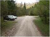
Access to starting point:
From the highway Ljubljana - Jesenice, we take the exit Radovljica (from the Gorenjska side, exit Lesce) and follow the road ahead in the direction of Begunje. At the end of the village Begunje, we turn left towards the Dom v Dragi (right Tržič). The asphalt road then brings us to the parking lot near the Dom v Dragi. We park a little further, as parking in front of the Dom v Dragi is allowed only for guests.
Route description:
From the parking lot, we continue on the road, which takes us past a bee house to a junction in a few minutes of walking, where we continue right in the direction of the Preval mountain pasture over Luknja (left Planinca mountain pasture, Poljška planina and Roblekov dom). The path ahead crosses the stream and then ascends gently for some time along the bottom of the valley.
Further, the valley narrows, and the path brings us in a moderate ascent to a narrow gully, through which we ascend steeply upwards with the help of fixed safety gear.
The short secured section is not particularly demanding technically, but it is exposed to falling stones.
Higher, the path brings us out of the gully, where it then continues for some time along the stream. There follows an ascent up a shorter ladder (undemanding), after which the path enters the forest, where it continues to a worse road.
We follow the aforementioned road for only a few steps, then the markers direct us right onto a marked footpath, which continues along and beside the cart track. Higher, the cart track finally turns into a footpath, which heads a little more to the right and begins to ascend ever more steeply. We follow this relatively steep path in the last part all the way to the Preval mountain pasture, which we reach after a few minutes of additional walking.

Photos:
 1
1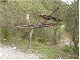 2
2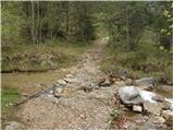 3
3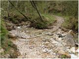 4
4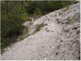 5
5 6
6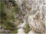 7
7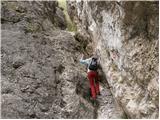 8
8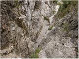 9
9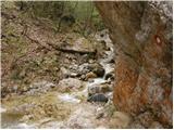 10
10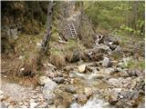 11
11 12
12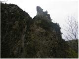 13
13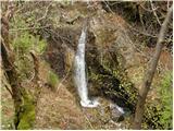 14
14 15
15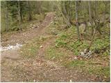 16
16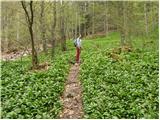 17
17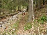 18
18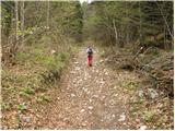 19
19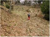 20
20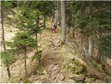 21
21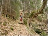 22
22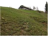 23
23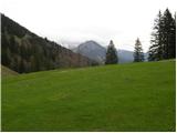 24
24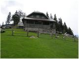 25
25
Discussion about the trip Dom v Dragi - Koča na Prevalu (via Luknja)
|
| pohodnica5328. 04. 2009 |
It looks like a wonderful path ; I'm "vertigo-prone", how exposed does the exposed part look (picture shows nicely, but I want more concrete), how many meters; is it comparable to Oljševa where a few m on pegs are needed-I survived there; thanks for answer ; I'm "vertigo-prone", how exposed does the exposed part look (picture shows nicely, but I want more concrete), how many meters; is it comparable to Oljševa where a few m on pegs are needed-I survived there; thanks for answer
|
|
|
|
| heinz28. 04. 2009 |
Hi!
Dear hiker 53, last time when I described the course of that path to you, I unfortunately wasn't aware of your vertigo. Had I known, I could have reassured you immediately, as nowhere on the path is fear needed, quite the opposite, you'll be glad to overcome the secured sections so easily, even my pampered dog climbed them without issue. Descent won't worry you either, as you'll go via ladder and pegs simply opposite to ascent, i.e. backwards.
Regardless of your current fears, believe you'll be thrilled and soon want to return to that path which needs no courage nor "luck". It's so pleasantly simple.
Nice hiking greetings!
|
|
|
|
| anč29. 04. 2009 |
On Saturday I went on this trail for the first time and it is really beautiful and especially uncrowded. Then over Rožca to Roblek. It was wonderful.
|
|
|
|
| pohodnica5330. 04. 2009 |
Thanks to everyone for the tips and encouragements, also to you heinz - it's already saved in bookmarks (and tadej your return), so it doesn't get lost by chance, until then, when I go; when I admire your described paths and pictures like this, my heart "aches", when there's a very nice tour, but in between there are a couple of scary pegs for me and so I have to give up on such a tour; if this one is really short and safe it will be just right, maybe I'll get used to it this way; I've been hiking for quite some time, just where it's safe; I wish everyone as much sun as possible and nice May Day hill wandering
|
|
|
|
| msing127. 07. 2009 |
on Sunday 26.07.09 on the way from Dom v Dragi to Planina Preval I found a GSM phone. Please, the owner contact me with a return message.
|
|
|
|
| VanSims12. 09. 2010 |
The trail is really not demanding and barely deserves the partially demanding rating. The secured section is short and non-exposed. First a few meters of cable and some pegs, then a short ladder and some bolts. The rest is nice walking through the forest.
Oh, at the end of the ladder a bolt sticks out from the rock (at least in my opinion unnecessary). Since I overlooked it, I really banged into it 
Otherwise, a very nice trail.
|
|
|
|
| ljubitelj gora6. 11. 2010 |
Yeah, that peg is really unnecessary there, you immediately bang your head into it.
|
|
|
|
| tango12. 01. 2019 |
Pleasant path and surprisingly, with full parking lots in Draga, not a single one encountered. From Planina Preval we looped the path via Planince back to Draga. Recommend, lunch tastes much better afterwards
|
|
|
|
| dolenjka12327. 04. 2022 21:00:47 |
Hi, this would be my first time here and I plan to go back the same way, do you recommend or advise against it? Which path could I take to get back to the same location where I left the car?
|
|
|
|
| franca27. 04. 2022 21:13:22 |
via Poljska planina and Planinca you get back to Draga
|
|
|
|
| Volja1. 10. 2023 22:33:11 |
The path from Draga through Luknja is heavily damaged due to August floods and closed. The cable is damaged and all pegs are missing entirely. The closure is marked only from the lower side, there are no signs from the planina.
|
|
|
|
| georgia9. 05. 2024 16:58:50 |
Is there anything new on this trail? Is it still damaged/closed? Thanks for the reply!
|
|
|
|
| BostjanZ7117. 06. 2024 18:13:16 |
The trail from Draga to Preval is still damaged and closed, the warning is right after crossing the stream. Checked today, I went to the fixed cable, but it's torn below.
|
|
|
|
| georgia25. 08. 2024 12:37:44 |
The trail from Draga over Luknja is open and passable again, although I haven't checked it personally, I was at Preval yesterday and saw hikers coming from that direction and the hut keeper at the pasture also confirmed that the trail is open.
|
|
|
|
| franca27. 08. 2024 17:20:54 |
Officially closed, people have been walking on it for some time now. I don't know if it has ever been maintained.
|
|
|
|
| georgia27. 08. 2024 17:46:08 |
At the mountain pasture, on the signpost for Draga, there is no notice that the path is closed. I don't know how it is in the valley.
|
|
|
|
| franca27. 08. 2024 18:31:06 |
On the maPZS map, which is quite up-to-date, it is marked as closed. On the mountain pasture a month ago there was no sign, in the valley there was. I don't know the current state in the field, the last description (on FB?) was that it is difficult to pass.
|
|
|
|
| Po Hodnik27. 08. 2024 21:45:21 |
Post on PZS FB marked the path as reopened
|
|
|
To post a comment you must log in:
If you do not yet have a username, you must first
register.