Dom Trilobit - Weinasch/Vajnež (via Skalaška pot)
Starting point: Dom Trilobit (939 m)
| Latitude/Longitude: | 46,4579°N 14,1031°E |
| |
Route name: via Skalaška pot
Walking time: 4 h
Difficulty: very difficult unmarked way
Elevation gain: 1165 m
Elevation difference along the route: 1165 m
Map: Karavanke - osrednji del 1:50.000
Recommended equipment (summer): helmet
Recommended equipment (winter): helmet, ice axe, crampons
Views: 19.053
 | 5 people like this post |
Access to starting point:
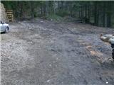
From the Ljubljana - Jesenice highway, we head to the Lipce exit, and then drive right towards Jesenice. In the settlement Javornik, at the first traffic-light intersection, we turn right (direction Lj.) towards Koroška Bela. At the next intersection with a traffic light, we turn left, and soon again left towards Javorniški Rovt. After a few kilometers of uphill driving (when we have already arrived in the mentioned village), in a sharp left bend, the macadam road branches off straight ahead towards Dom Trilobit (sign). After a few 100 m, we arrive at the lake, by which the road runs, and on the left we notice Dom Trilobit. When we drive past this structure, the road in the forest ends, and here is our starting point.
Route description:
On the left side from the starting point, uphill leads a somewhat damaged cart track, on which we head and at the same time encounter the first blaze. After a few minutes, we notice a branch-off of the cart track to the right towards the mountain pasture Stamare, but we continue straight to the spot where the path approaches the streambed of the stream. Here the cart track turns left and ends at the upper spring of the Javornik stream or transitions into a forest path. This one starts to ascend ever more steeply, first straight, then winding through the forest. On the left, we will be able to notice a monument with a fence, and after only 45 minutes of walking arrive at the second monument (to the hunter) by the path, where on the right there is a completely destroyed bench. The steepness eases somewhat, and the path directs left towards the north, where for some time it runs through a mixed woodland. Here, on the right, first we can observe the screes of Srednica, later a view gradually opens eastward towards the amphitheater Rida. We can observe it fully thereafter when the forest transitions into a belt of dwarf pines. A few more zigzags and we are already near the mountain pasture Seče, where on a tree we encounter direction signs.
We continue only slightly right along a less pronounced valley towards the border ridge to the north. When we reach it (border stone), we head right, where we continue uphill among dwarf pines along the border ridge, where the path occasionally runs along the right edge. When we arrive at a fairly narrow part of the ridge, the more demanding part of the path begins, followed first by a steep rocky descent along an aluminum wire rope unsecured below. Then we find ourselves on an even narrower part of the ridge, where the path (first right) runs between and alongside dwarf pines. Soon another short descent follows over very crumbly rocky terrain, and the path thereafter gradually turns to the left side of the ridge, where it soon steeply ascends back to its top along an aluminum rope. Exposure and difficulties do not ease, and we find ourselves before the third obstacle: an almost vertical chimney equipped with the same rope and steel pegs. When we reach its top, the path runs along the right side of the ridge, where it ascends slightly and then descends more steeply, and soon along a similar rope also very steeply ascends eastward (caution, wet terrain!). Towards the top of the ascent, the path turns right, where later we find ourselves among dwarf pines at the end of the Skalaška pot.
We continue along the top of the border ridge in the direction of Mali Vrh, where the path with beautiful views leads us to its summit. From here we continue in the same direction, where we still walk along the ridge path beside the northern precipices of Belščica, which after some time finally brings us near the saddle west of Vajnež, onto which we climb in a few steps of further walking.

Photos:
 1
1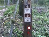 2
2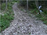 3
3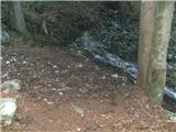 4
4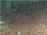 5
5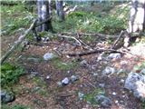 6
6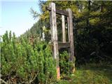 7
7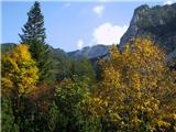 8
8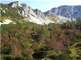 9
9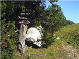 10
10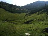 11
11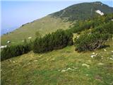 12
12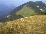 13
13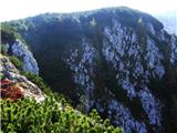 14
14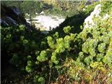 15
15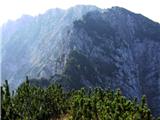 16
16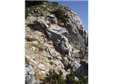 17
17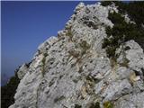 18
18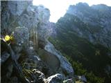 19
19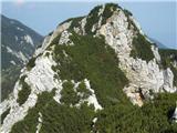 20
20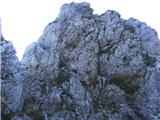 21
21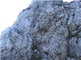 22
22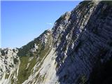 23
23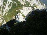 24
24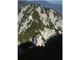 25
25 26
26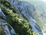 27
27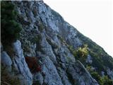 28
28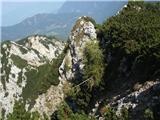 29
29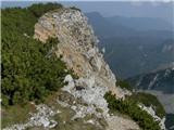 30
30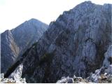 31
31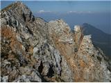 32
32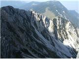 33
33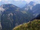 34
34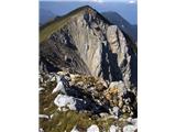 35
35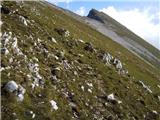 36
36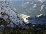 37
37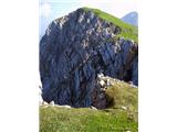 38
38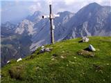 39
39
Discussion about the trip Dom Trilobit - Weinasch/Vajnež (via Skalaška pot)
|
| heinz29. 09. 2009 |
Despite ropes at four points on the Skalaška pot, it could be said that the path is not properly secured and therefore (also due to humidity), quite dangerous. It is intended only for hikers with sufficient experience in walking and climbing off-trail. Not for those afraid of heights. The rest of the path is easy.
Good luck, Heinz!
|
|
|
|
| nata243. 07. 2010 |
I'm wondering if the path from planina Seče is hard to follow or well trodden?
|
|
|
|
| heinz3. 07. 2010 |
From Seč border ridge it's not hard to find (slightly right of the first wooden signs, along a less pronounced valley). When we reach the border stones we turn right along the border forestry track (path). Visible yes, trodden - so/so. When we reach the more demanding part of the path there's almost no trail. The direction from here could be classed as demanding pathless terrain. Orientation somewhat difficult.
..Once we reach the vertical section with pegs (called Viševnik), we don't climb fully to its top, but as stated in the description, continue on the right side of the ridge first slightly up, then descent on steep terrain where we find the last rope along which on wet steep terrain we climb some 10 m towards the outlet of Skalaška path.
Path is crumbly, in the guidebook of a known author marked as -very demanding path/ pathless.
I also thought of suggesting to the administrator to change difficulty to "very demanding", which it actually is.
Otherwise short and varied.
One more: caution for rockfall due to path through Rido running below!
I enjoyed this section myself. Believe you will too!
Good luck, heinz!
|
|
|
|
| nata244. 07. 2010 |
It went without problems, found the trail, but I was wet and dirty up to my butt. At the vertical section there's now an "ornk" cable. I then continued to Potoški Stol, even saw 2 marmots and returned via the lower marked trail, which drags on veeeeeery long. Lp
|
|
|
|
| heinz4. 07. 2010 |
Yes, the lower one does drag a bit at first.
At which vertical part; where there are pegs, or at the last ascent that ends among the scree? The cables were bright or aluminum. But the first one was loose at the bottom - pulled out with the peg.
Where did you come across the marmots? In Rida?
|
|
|
|
| nata244. 07. 2010 |
Besides the thinner cable like the one at the first descent, there was another thicker one next to it, but I don't know if at the pegs or at the end (early rising obviously has consequences). I saw the marmots among the rocks before climbing up to Potoški Stol.
|
|
|
|
| Majdag3. 09. 2011 |
...Dom Trilobit, Skalaška, Mali Vrh...Well, I finally did it, that Skalaška has tempted me all summer. Wonderful views, unique. Continued to Mali Vrh, but returned through Rido. No regrets, super
|
|
|
|
| green joga6. 01. 2012 |
Has anyone been here recently who knows what the winter conditions are like?
|
|
|
|
| heinz7. 01. 2012 |
Perfect winter conditions: snow up to half a meter, even more in places. In general, without full gear, the Skalaška route won't be feasible.
|
|
|
|
| ljubitelj gora20. 05. 2012 |
Today I took this path and further towards Stol, as heinz said in the first comment, otherwise the path is dry.
|
|
|
|
| Metka Polpetka7. 07. 2014 |
Yesterday went via Skalaška. In the brush the path is quite overgrown. All fixed cables hold in the upper part, the rest is collapsed. The lower two brackets very loose, the third still usable for now, also the handholds there are quite loose. Shame, because it's falling apart like this, just in this key part soon everything will be on the cable, which you can never trust 100%, because you don't know its condition up top. Otherwise a wonderful, wild path!
|
|
|
|
| heinz7. 07. 2014 |
Indeed, this Skalaška is quite wild.. If no one takes care of adapting it, it will be even more so in the future.. Since it's unmarked, it's considered pathless and that's probably why no mountaineering club maintains it. But it's definitely one of the most beautiful in the Karavanke.
|
|
|
|
| VanSims30. 07. 2018 |
Wild, wild yeah. When I got from the brush to the ridge and down the first cable, after about 10 meters I already said to myself: ouch, no more joking here!  
The initial path from the saddle through the brush,... hmmm... once you find it, it's yours,... more or less. I'd say it's the opposite of what @heinz said: Visible so-so, but well-trodden yes.
After an hour of thrashing through the brush, possibly wet from the previous night's storm, as in my case, then the reward with a solid, how good one-hour adrenaline dose! 
|
|
|
|
| anze r21. 10. 2023 00:14:30 |
Is there perhaps anything new (worth mentioning) on Skalaška now?
|
|
|
To post a comment you must log in:
If you do not yet have a username, you must first
register.