Dolina Todorov do - Prutaš
Starting point: Dolina Todorov do (1820 m)
| Latitude/Longitude: | 43,12772°N 18,98763°E |
| |
Walking time: 1 h 30 min
Difficulty: partly demanding marked way
Elevation gain: 573 m
Elevation difference along the route: 575 m
Map: Durmitor 1 : 22000
Recommended equipment (summer):
Recommended equipment (winter):
Views: 3.260
 | 3 people like this post |
Access to starting point:
Approximately 4 km south of Žabljak we find the junction from the Žabljak-Nikšić road to the Žabljak-Sedlo-Trsa-Plužine road (currently the junction is not marked!) and drive along a flat, high-alpine, fully asphalted road over the Sedlo saddle to the Todorov Do valley, located directly below the western slope of Prutaš (ca 24 km from Žabljak, ca 10 km from Sedlo). We park at a small parking lot by the turn-off to the gravel road leading to the pasture.
Route description:
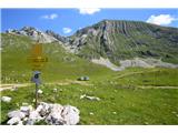
At the starting point Prutaš stands in full grandeur before us. The path first leads across the pasture past the watering pond and trough (a couple of minutes). Then we ascend relatively evenly and steeply, continuously along the western slope or towards the saddle visible from below to the left of the summit (between Prutaš and Gruda). Partly over grassy terrain, partly over scree. Just before the saddle (about 1:00 to here) we turn right and steeply up the rocky northern ridge. Higher up we traverse left to a short steep gully, via which (slightly exposed) we emerge onto a gentler grassy ridge. After a couple of minutes on the ridge we stand at the fore-summit, where at a well-marked junction we take right or straight on (left goes the path towards Škrčka lakes). In a couple of minutes we step onto the expansive grassy summit.
Suggestion for a short extension: From the summit it makes sense to descend 15 minutes or 50 elevation meters along the path towards Škrčka lakes, as from the lower parts of the ridge a nice view of the lakes opens up.

Photos:
 1
1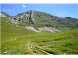 2
2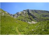 3
3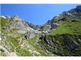 4
4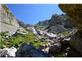 5
5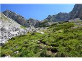 6
6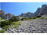 7
7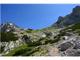 8
8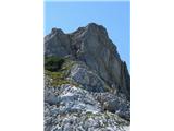 9
9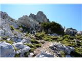 10
10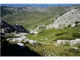 11
11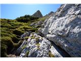 12
12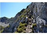 13
13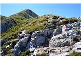 14
14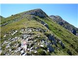 15
15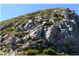 16
16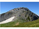 17
17 18
18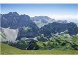 19
19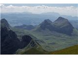 20
20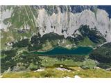 21
21
Discussion about the trip Dolina Todorov do - Prutaš
|
| nejka4029. 06. 2019 |
Wonderful mountain with magnificent views, short but sweet, only the last part - picture 14 is a bit exposed, but plenty of holds, solid rock.  . .
|
|
|
To post a comment you must log in:
If you do not yet have a username, you must first
register.