Starting point: Dolina Krma (930 m)
| Latitude/Longitude: | 46,3851°N 13,9071°E |
| |
Walking time: 2 h 55 min
Difficulty: difficult marked way
Elevation gain: 1078 m
Elevation difference along the route: 1100 m
Map: TNP 1:50.000
Recommended equipment (summer): helmet
Recommended equipment (winter): helmet, ice axe, crampons
Views: 14.247
 | 2 people like this post |
Access to starting point:
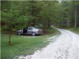
a) We leave the Gorenjska motorway at the Hrušica exit and follow the road further in the direction of Kranjska Gora. Just a little before the village of Dovje, a road branches off to the left from the main road, leading to Mojstrana (Vrata, Kot and Krma). We continue following the road in the direction of the village of Radovna and the Krma and Kot valleys. The relatively steep road then leads us past the TNP sign, after which the road soon levels out and brings us to a junction, where a gravel road branches off to the right into the Kot valley. We continue straight on the road, which begins to descend. In the middle of the descent, a road branches off to the right into the Krma valley (straight ahead Radovna). A little further on we come to the next junction, where we continue right in the direction of Krma. The gravel road then brings us to Kovinarska koča, and we follow it further. The occasionally somewhat worse road then brings us to the parking lot before the barrier.
b) We drive to Kranjska Gora, then continue driving in the direction of Jesenice. At Dovje we leave the main road and continue right in the direction of Mojstrana and the valleys of Vrata, Kot and Krma, following the signs for Krma at the subsequent junctions. The relatively steep road then leads us past the TNP sign, after which the road soon levels out and brings us to a junction, where a gravel road branches off to the right into the Kot valley. We continue straight on the road, which begins to descend. In the middle of the descent, a road branches off to the right into the Krma valley (straight ahead Radovna). A little further on we come to the next junction, where we continue right in the direction of Krma. The gravel road then brings us to Kovinarska koča, and we follow it further. The occasionally somewhat worse road then brings us to the parking lot before the barrier.
Route description:
From the parking lot we go back a few dozen steps, then turn right (from the direction of access to the starting point left), towards the east on the path in the direction of Blejska koča na Lipanci. Initially we ascend only gently, but already after three minutes of walking the path becomes steep, and a few minutes higher we arrive below the cliffs, where we notice an inscription that the path we will continue ascending on was built in 1952.
The path ahead climbs steeply through the forest to a somewhat more demanding passage, where we are helped by pitons, less steep steps and a steel cable. The path then takes us among the dwarf pines and we follow it further to a mighty torrent gully. To the gully we first descend a bit, on the other side we climb transversely across the steep slope. Crossing the gully is made difficult or even impossible after heavy rain, but since the slopes are steep the water drains quickly. The path ahead then ascends through the forest, still steeply upwards. The path gets closer and closer to the steep slopes and rock faces. When the forest becomes much sparser, the path climbs even steeper and for a short time becomes so steep that we have to help ourselves a little with our hands. This part of the path is especially dangerous for slipping when wet, but when dry it does not pose greater danger. The path then takes us below steep rock faces, where there is a great danger of falling rocks, especially in springtime and after rain. We cross below the faces almost horizontally, then the path climbs again. Again a steel cable helps us, which takes us to grassy slopes. Further we again cross slopes exposed to falling rocks and soon after come to a less steep part of the path. Further we ascend on an increasingly scenic path mostly among dwarf pines and sparse forest to a junction, where we turn left towards Debela peč and Lipanska vrata (right Lipanski vrh and Mrežce).
The path ahead climbs transversely to the left and in a few minutes of moderate ascent takes us to Lipanska vrata, from which we descend a few steps to a junction.
We continue left towards Debela peč and Brda and Blejska koča (right Kredarica (peak above Lipanska vrata), Lipanski vrh and Mrežce) and continue the path transversely below the lesser-known Vrh nad Rdečim, where a belt of dwarf pines accompanies us along the path.
When the belt of dwarf pines ends, from the junction we continue on the upper path (slightly right Blejska koča na Lipanci), which leads further towards Debela peč.
For a few minutes we continue in a slight transverse ascent to the right, then we go left upwards in the direction of the Brda summit (sometimes also written as Brdo).
From the fork onwards the path is initially somewhat less visible, higher up the more distinct path then takes us to a technically undemanding ridge, where it turns right and then quickly takes us to the 2008 meter high summit amidst increasingly beautiful views.
Starting point - junction below Lipanska vrata 2:25, junction below Lipanska vrata - Lipanska vrata 0:10, Lipanska vrata - junction below Vrh nad Rdečim 0:05, junction below Vrh nad Rdečim - fork for Brda 0:05, fork for Brda - Brda 0:10.

Along the route: Pod Lipanskimi vrati (1656m), Razpotje pod Lipanskimi vrati (1878m), Lipanska vrata (1905m), Razpotje pod Vrhom nad Rdečim (1903m), Odcep za Brda (1925m)
Photos:
 1
1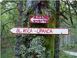 2
2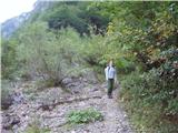 3
3 4
4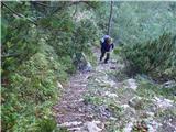 5
5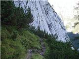 6
6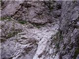 7
7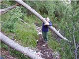 8
8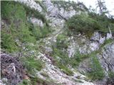 9
9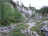 10
10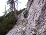 11
11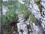 12
12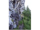 13
13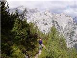 14
14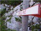 15
15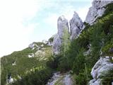 16
16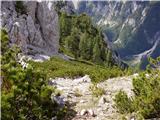 17
17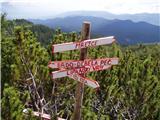 18
18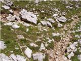 19
19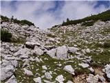 20
20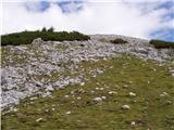 21
21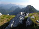 22
22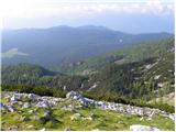 23
23
Discussion about the trip Dolina Krma - Brda
|
| Ajda_Zitnik8. 07. 2012 |
I walked the path today. I would just add to advise inexperienced hikers against this path - especially if returning on it. The path is steep in the true sense of the word and downhill can sometimes cause the same problems as uphill.
Furthermore, I would note that the time may be a bit strictly estimated. If you check pzs.si, at the Kovinarska koča you see it takes 4 hours to Debela peč. From Brda to Debele peči, believe me, you don't need 1 hour 15 minutes, but maybe 30 to 45 minutes. I would say walking time 3 hours 15 to 3 hours 30 min.
|
|
|
|
| Ajda_Zitnik8. 07. 2012 |
Oh, and also, the elevation gain on the path is at least 1100 m in my estimate, because you descend several times by 5 and 10 m and then have to make it up.
|
|
|
|
| KarmenT31. 08. 2019 |
Today for the first time on this path. Path well trodden, but very steep, except for the first few minutes and the last part. Great help from "rocky" holds and bushes. A few minutes from the start, left in the gully there's a stream in the forest, but no path leads to it. Peaks above Dolina Krma stunningly beautiful, slopes very steep. Triglav and Rjavina covered in clouds all the time. Lipanska vrata possible. Didn't meet anyone on the path, otherwise parking in Krma full. Windy at the top, also awaited some sunshine. Interesting path
|
|
|
|
| Majdag1. 09. 2019 |
KarmenT, according to the description Lipanska vrata are at the signposts, on the ridge.. Maybe someone knows?
|
|
|
To post a comment you must log in:
If you do not yet have a username, you must first
register.