Dol - Stegovnik (through window)
Starting point: Dol (850 m)
| Latitude/Longitude: | 46,3826°N 14,4445°E |
| |
Route name: through window
Walking time: 2 h 35 min
Difficulty: easy unmarked way, partly demanding marked way
Elevation gain: 842 m
Elevation difference along the route: 870 m
Map: Karavanke - osrednji del 1:50.000
Recommended equipment (summer): helmet
Recommended equipment (winter): helmet, ice axe, crampons
Views: 61.019
 | 6 people like this post |
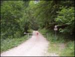
Access to starting point:
From the highway Ljubljana - Jesenice we take the exit Kranj - east and follow the road ahead in the direction of Jezersko, but only to the inn Kanonir, where we turn left. We further follow at first still the asphalted road, but only to the approximately 2 km distant crossroads, where the road to Stegovnik branches off to the right. We head onto this road, which we follow for a few hundred meters to the barrier, where we park on a smaller parking lot.
Route description:
From the gate we continue on the forest road which after approximately 20 minutes of ascent brings us to a larger clearing, on the edge of which there is a holiday cottage (to here possible also on marked shortcuts).
At the beginning of the mentioned clearing we notice signposts for Stegovnik, we go left and continue the ascent on the forest road. We follow the mentioned road for a little less than 20 minutes, to a slight left bend, in the middle of which a relatively steep cart track branches off to the right. We head onto the mentioned cart track, beside which we notice "unofficial" blazes. After a few minutes of ascent on the cart track, we arrive at a smaller junction, where we continue on the left cart track, beside which we still notice some "unofficial" blazes. The cart track then brings us to a clearing, where it changes into a barely visible but still marked path. Here the path turns right and ascends to a larger boulder, which we notice somewhat above us.
At the boulder we step again onto the marked path, which we follow left (right Močnikovo sedlo). The path ahead in a gentle ascent crosses the southeastern slopes of Stegovnik, then starts to ascend more steeply. After a few minutes of ascent, the path brings us to the saddle between Stegovnik on the right and Mali Javornik on the left.
Here we continue right (left Javorniški preval) along a short connecting path, which first across the clearing, then through the forest brings us to the next junction.
We again continue right in the direction of Stegovnik (left mountain pasture Javornik) on the path, which after a few more steps brings us to the natural window in Stegovnik. The well-secured path with the help of a steel cable brings us to the window, then with the help of a ladder we descend to the adjacent window, from which we descend to the other side of the ridge.
Further the path in numerous zigzags ascends steeply and higher brings us to the main ridge, where it turns left. A steep ascent follows, which we overcome with the help of a steel cable (undemanding), then the path brings us to the western forepeak of Stegovnik. A gentle descent follows, then the path continues along the very panoramic ridge. After more than 10 minutes of walking along the locally slightly exposed ridge, the path brings us to the summit of the 1692 m high Stegovnik.

Along the route: Okno v Stegovniku (1460m)
Photos:
 1
1 2
2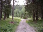 3
3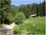 4
4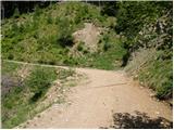 5
5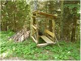 6
6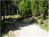 7
7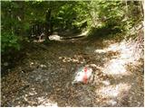 8
8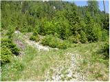 9
9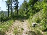 10
10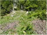 11
11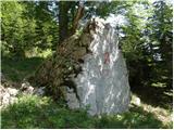 12
12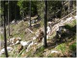 13
13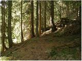 14
14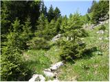 15
15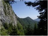 16
16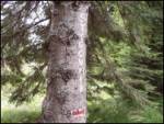 17
17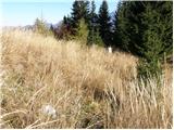 18
18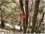 19
19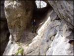 20
20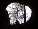 21
21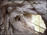 22
22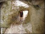 23
23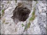 24
24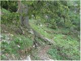 25
25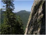 26
26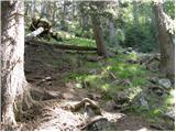 27
27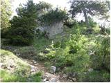 28
28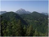 29
29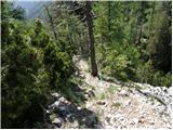 30
30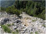 31
31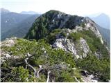 32
32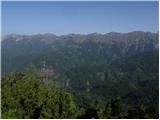 33
33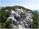 34
34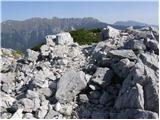 35
35
Discussion about the trip Dol - Stegovnik (through window)
|
| ROBERT22. 08. 2006 |
The window is fascinating......worth seeing!
|
|
|
|
| jerinjan30. 08. 2009 |
Nice trip, the window is really something special 
However, the described path is partially buried due to avalanches, partially completely overgrown and there are still quite a few huge logs in between... so good orientation is needed and especially careful observation of the surroundings to spot the sometimes really hard-to-see path or markers.
|
|
|
|
| Bojan_A28. 07. 2010 |
Today I did a training on Stegovnik. Started below Dom pod Storžičem and then through the windows to Stegovnik. On the way back, I went over Močnikovo sedlo. This path is very poorly visible and hard to follow.
|
|
|
|
| Anthony3. 03. 2011 |
Hello.
If someone has hiked to Stegovnik recently, I'm curious about the current conditions.
Best regards
|
|
|
|
| asde14. 03. 2011 |
Hello,
on Saturday, 12.03.2011 we headed to Stegovnik. Start of the path Dom pod Storžičem, over Javorniško sedlo, then under M. Javornik.
Snow in shady areas up to 30cm, elsewhere 5-10cm.
Stegovnik itself is completely bare, but we didn't find the path to the summit, the markers are obviously on the ground, covered with snow. The path is otherwise very hard to follow, a bit of criticism for PD Tržič and the markers.
|
|
|
|
| garmont17. 03. 2011 |
In general, in winter don't go where you haven't hiked in summer, because then you obviously wouldn't have problems with markers. Don't take the remark badly, as there are far too many cases of people getting lost in winter because they end up in a completely unfamiliar world to them, whereas if they had hiked there in summer it would probably be different.
LP
|
|
|
|
| micamaca19. 11. 2011 |
Today's escape from Ljubljana fog paid off handsomely. The idea to head towards Jezersko fell already yesterday evening, but today on the spot Stegovnik offered itself we started in Dol, climbed via Močnikovo sedlo to Stegovnik, then descended past or through Swiss cheese  the entire path is wonderful, especially the ridge section rich with beautiful views! the entire path is wonderful, especially the ridge section rich with beautiful views!
|
|
|
|
| lakkon7. 07. 2013 |
In the introduction it says it's an easy unmarked trail. In the description regarding trail markings: "unofficial" markings; ...into a barely visible but still marked trail.
But is this trail currently well (visible) or perhaps decently marked in some way so that if you pay attention you can't really get lost?
Soon I would do a circular Stegovnik. Up this trail, down
http://www.hribi.net/izlet/dol_stegovnik_cez_mocnikovo_sedlo/11/442/653
|
|
|
|
| Stane78. 07. 2013 |
Both paths are sufficiently marked, you won't have any problems.
|
|
|
|
| lakkon8. 07. 2013 |
Stane7,
thanks for the feedback.
I know it would probably work even without extra help. But I plan to do this in the morning or afternoon during the week, when work limits me anyway. Even an additional hour could be a problem. Especially if you're coming from the Dolenjsko-Posavje area, right?
|
|
|
|
| capek25. 07. 2013 |
25.07.2013. Trip Dol - Stegovnik - through the window. From the tourist hut onwards, you have to be quite attentive to all kinds of markings (especially at the beginning, on the 'unofficial' ones). AND so all the way to the boulder. Even a small carelessness can lead you "a bit straight" and you're there.
It's very interesting that this path (Dol - Steg. - through the window) is not marked on any map and even more interesting to me is that the 'window' is not marked anywhere, yet it's so fantastic. The announced time of 2.35 h is of course without any view and enjoyment. The trip is strenuous but worth it.
|
|
|
|
| Lisica1. 09. 2013 |
The trail description is not very good.  From the barrier, after the first 20 minutes the trail only reaches the junction - we go right following the blazes, then soon there's a marked path to the left (that's the shortcut through the forest with poor markings), when we reach the road again we go up the hill along it for about 5 min to the holiday cottage, there we have the option of two paths - the one described or over Močnikovo sedlo. We can also make a loop up one and down the other. From the barrier, after the first 20 minutes the trail only reaches the junction - we go right following the blazes, then soon there's a marked path to the left (that's the shortcut through the forest with poor markings), when we reach the road again we go up the hill along it for about 5 min to the holiday cottage, there we have the option of two paths - the one described or over Močnikovo sedlo. We can also make a loop up one and down the other.
Stegovnik is really beautiful, as is the window. The hike didn't seem strenuous to me. There was no need for a helmet, but some caution is required because the terrain is crumbly in places and the markings are very poor. It's really under-visited for the beautiful views it offers.
|
|
|
|
| smatjaz15. 10. 2013 |
Lisica, today I visited Stegovnik and I have to say it is an exceptional trip, especially since I climbed through the window and returned via Močnikovo sedlo, as you suggested. The administrator can safely adjust the time to 3 hours, as that is what an average hiker uses for the ascent. Major criticism goes to the Mountaineering Association responsible for these paths, as the markings are in a condition as if made somewhere between World War I and II, and some are missing here and there because foresters felled the tree they were on, so at the holiday cottage there is no marking for the left direction through the window (I didn't find it on any map except hribi.net), later they disappear too, already at the junction from the forest path, all the way to the window!!! On top of everything, pathfinding is hindered by ongoing timber hauling which causes many new paths that can mislead. Lisica, without your description it would have been very difficult - thanks! Given that jerinjan 2009 and bojan a 2010 already warned about poor markings, it is high time for the mentioned PD to take action, as it obviously doesn't realize what a gem it has. Returning via Močnikovo sedlo is a bit easier because the path is more worn as many visitors don't know about the path through the window and use via the saddle. Major criticism goes to the Mountaineering Association responsible for these paths, as the markings are in a condition as if made somewhere between World War I and II, and some are missing here and there because foresters felled the tree they were on, so at the holiday cottage there is no marking for the left direction through the window (I didn't find it on any map except hribi.net), later they disappear too, already at the junction from the forest path, all the way to the window!!! On top of everything, pathfinding is hindered by ongoing timber hauling which causes many new paths that can mislead. Lisica, without your description it would have been very difficult - thanks! Given that jerinjan 2009 and bojan a 2010 already warned about poor markings, it is high time for the mentioned PD to take action, as it obviously doesn't realize what a gem it has. Returning via Močnikovo sedlo is a bit easier because the path is more worn as many visitors don't know about the path through the window and use via the saddle.  I must also thank two friendly young ladies whom I met on the ascent and who helped me with directions on the path. I must also thank two friendly young ladies whom I met on the ascent and who helped me with directions on the path. In spring I will return and do the ascent from the opposite side and extend it to the hut below Storžič. And if the markings are not repaired, I will carry that "kilo" of paint up myself and fix them. In spring I will return and do the ascent from the opposite side and extend it to the hut below Storžič. And if the markings are not repaired, I will carry that "kilo" of paint up myself and fix them. Well, anyone heading up should heed Lisica's advice - it helps. Good luck and safe steps to all! Well, anyone heading up should heed Lisica's advice - it helps. Good luck and safe steps to all!
PS: the criticism to the markers was not malicious, it was just expressed as a wish for something to move in this area, right?
|
|
|
|
| martinkarpan30. 03. 2014 |
Today first time to Stegovnik via the window, the uphill path is catastrophically marked, overgrown, and about 10 meters to the side there's another path that runs long, marked with two parallel lines, which confuses you even more and you can stray off the path in a moment. My buddy and I missed the path at least 10 times altogether, considering snow patches that probably covered the ground marks....so a path that's not really a path. It took us a solid 3h 20min to the top.
We were apparently the first this year up there, as everything was still "wild", no tracks in the snow.
We also returned the same way, because descent to Močnikovo sedlo is still too dangerous. And ironically, on the descent there are significantly more markings, and following the "path" much easier.
I don't know why the markers don't fix these paths, no wonder they're all overgrown since no hiker wants to spend an extra half hour on orientation.
|
|
|
|
| dprapr30. 03. 2014 |
Some want to spend the entire time just on orientation, not just half an hour!
|
|
|
|
| smatjaz30. 03. 2014 |
dprapr, but krpan is right, me too as I already described in September last year I was looking for the path and without GPS and instructions would have been at least 5-10x on the wrong path. I feel that this path is intended only for a few chosen ones who know this end of the country, but am I wrong given the remarks and complaints about markings on the path since 2009 onwards, or does everything work here like in our country? 
|
|
|
|
| matic426. 04. 2014 |
From the barrier to the holiday hut is 40 min. fast walking (for the whole path I used just over two hours). The path from the hut to the boulder is officially not marked, but there are enough signs. Overall, the entire path is barely marked. Today I was up there, the path is dry, only on the ridge there are a few snow patches.
|
|
|
|
| Dr.2. 05. 2014 |
The path is not marked because it is not in the register of mountain trails. The description clearly states that it is an unmarked path.
|
|
|
|
| smatjaz3. 05. 2014 |
Dr. OK, I completely agree with your explanation, but not with the fact why such an interesting path is unmarked, as if someone wanted it hidden??? 
|
|
|
|
| franca3. 05. 2014 |
Isn't discovering and searching for the path a special charm?
|
|
|
|
| mjk25. 06. 2016 |
Today I went on this trail and have to admit it's excellent
... regarding orientation it's like this ... the trail is still not drawn on the map and is unmarked ... so you have to prepare in advance ... from the tourist hut to the right junction (in the left bend) everything is ok (the picture says it all) and can be found, then additional caution is needed and following instructions ... first straight then soon after the right bend left (there was a cairn today) then follow the slightly overgrown path (hardly a cart track) to the clearing approx. 15 min (which is no longer so obvious ) and then by azimuth almost to the wall. Here you pick up the well-marked path that runs under the wall (or a bit lower). Probably any direction towards the wall leads to the same result, just not everyone wants to bushwhack. Here the orientation difficulty ends, as the marked path is very well marked all the way to the top ... p.s.: the path over Močnikovo sedlo is now also well marked ... apparently someone renewed the markings. excellent tour ... timing is ... if we calculate 1h per 400m + 5km/h ... it comes to about 3h, but due to the steep terrain when gaining height quickly, it's accurate ... in very poor condition I just made it ... very nice tour, because the window is worth seeing
|
|
|
|
| mjk25. 06. 2016 |
P.s.: That junction with the cairn is also in the picture above ...
|
|
|
|
| Batistuta10. 07. 2017 |
Today I descended from Stegovnik down through the window, which is extremely fascinating as it has 5 eyes (I think the most beautiful window in Slovenia).
Essential information for everyone who wants to go down another path (or up): the map is missing the marked connection between two paths that run parallel towards Javorniški preval. Between these two paths there is a marked very well visible easy walking trail that is not drawn on any map. So if you are descending from the top through the window, continue for about 5-8 minutes along the marked path, then there is a fork where both paths are marked. One goes right level, the other left upwards - choose that one. It will take you to a marked junction with a sign that will direct you to Močnikovo sedlo. This way you can make a loop that you close at the saddle. Then continue to the valley along the same path.
|
|
|
|
| gitka16. 10. 2017 |
Hi, I just spent a nice autumn day on Stegovnik today. I must say, everything is very beautiful, especially the unforgettable views of nearby and distant neighbors, particularly the colorful nature, larches, beeches... everything glows in the autumn sun.
So, if you want to enjoy the views of the colorful larches, just put the path under your feet, Stegovnik invites
best regards
|
|
|
|
| CarpeDiem2471. 11. 2018 |
Yesterday we did this nice autumn circular tour; up through the window and down via Močnikovo sedlo. Nice
|
|
|
|
| smatjaz2. 11. 2018 |
You forgot to mention Pa Ruš!!! Otherwise, the path through the windows is quite okay with some fallen trees and an easy bypass, through Močnikovo sedlo there is quite some damage from the windthrow and a bit more obstacles to bypass, but far from being impassable......
|
|
|
|
| siddh22. 04. 2019 |
I wouldn't really recommend this trail currently. On the way up through Močnikovo sedlo we got lost despite effort, because around Močnikovo sedlo there is logging that hinders finding markings and also the path (need to stick to the far left). The path from the windows is, although well marked, really very obstructed - huge number of fallen trees and boulders over which you have to climb or go around.
|
|
|
|
| trdi14. 07. 2019 |
I went to the summit past Močnikovo sedlo and returned past the window down, but I apparently missed the junction at the said or similar boulder, so I returned again past Močnikovo sedlo. Probably it would be better to do the tour in the opposite direction, but nevertheless the variant past the window to the summit seems to me much steeper and more strenuous than from Močnikovo sedlo, so I'm still quite satisfied with the direction choice.
|
|
|
|
| navdušena4. 05. 2020 |
Has anyone been to Stegovnik this year via this trail? What's the condition?
|
|
|
|
| trilko22. 06. 2020 |
Today from Kanonir through the window to Stegovnik. Trail without peculiarities, except one section of unmarked path which due to fallen trees is somewhat more orientationally demanding.
|
|
|
|
| Zdenkob24. 07. 2020 |
On Monday, 20 July I ascended Stegovnik from Dol through the window, descended via Močnikovo sedlo. The path from Dol through the window is not officially marked, but can be aided by unofficial markers and this description and comments. On the path there are some clearings where markers are lost, and many fallen trees which must be bypassed or climbed over or crawled under - both on ascent and descent. Probably this is the reason for modest visits to this peak, which otherwise offers nice views.
|
|
|
|
| tango28. 10. 2021 14:38:57 |
Up through the window, back over Močnikovo sedlo. The approach from the junction with the Močnikovo sedlo path (at the boulder) to the saddle between Mali Javornik and Stegovnik requires some scrambling over fallen trees, but the windows were "cleaned to zero". From the top we descended to Močnikovo sedlo, that part of the path is really well maintained. Larches in gold, views beautiful!! It's unbelievable that with my wife on such a day and even during vacation time we didn't meet anyone on the entire path. Heaven!!!
|
|
|
|
| Darxta5. 09. 2022 11:31:03 |
The beginning of the route description here is really misleading. It would be better if instead of the first sentence it said the same as for the route over Močnikovo sedlo:
"From the barrier we follow the forest road, which after about 20 minutes brings us to a junction. We turn right and follow the road to a larger meadow where there is a house."
Yesterday, because of the wrong first junction, we were looking for a path that didn't exist, and somehow ended up at an unnamed summit near the end of the forest road SE of Stegovnik. A little below this summit on the W side, we found a marked path from Planina Javornik. The summit of Stegovnik is left for next time
|
|
|
|
| anica.zu12. 10. 2023 20:18:30 |
The path is completely newly marked, so no problems. From the window upwards it's very steep all the way to the summit ridge. Otherwise a wonderful path with exceptional views from the top.
|
|
|
|
| bo_zl5. 05. 2024 14:29:32 |
The path through the window and onwards is really well marked. Only on the clearing by the house there's a missing signpost that you continue on this path along the road. At the junction from the road to the cart track, there are two markings on the trees, one quite large, so you really can't miss the junction from the road. The window is interesting that it exists.
|
|
|
|
| Uporabnik47. 06. 2025 15:13:46 |
I can't believe how poorly marked the path is. We went up through the window and down to Mocnikovo sedlo. My advice is not to look at these pictures or read the description at all, because these unmarked paths and unofficial markers can't be found or don't lead anywhere, we got lost several times. I recommend going to the holiday cottage just by road, which takes about 40 min. From there, continue past the cottage on the road, after 10-15 min there will be an official marker on 2 trees on the right, turn up there onto the cart track, from there on there are signs. We went down to Mocnikovo sedlo, at the beginning it's easy to follow to the saddle, then suddenly a million markers in every direction, without signs!! In the end we looked for parking on google maps and went on bluff against the direction of that holiday cottage. Really a disaster of markings, especially because there are no signs. It has never happened to me that we got so lost on the way up and down. I don't know why the description says that you reach the cottage in 20 minutes … I really advise not to follow unofficial markers on the way up. Neither blue nor orange ones. They don't lead anywhere. Otherwise, if you have a desire or idea for some other mountain, better go there. Here there are really a lot of kilometers just road. We met several hikers from different sides and they all got lost on the path.
|
|
|
To post a comment you must log in:
If you do not yet have a username, you must first
register.