D postaja - Velika Črnelska špica
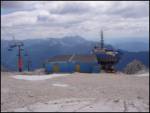
Starting point: D postaja (2202 m)
| Latitude/Longitude: | 46,3326°N 13,5384°E |
| |
Walking time: 3 h 35 min
Difficulty: difficult marked way
Elevation gain: 130 m
Elevation difference along the route: 650 m
Map: Julijske Alpe - zahodni del 1:50.000
Recommended equipment (summer): helmet
Recommended equipment (winter): helmet, ice axe, crampons
Views: 20.464
 | 3 people like this post |
Access to starting point:
a) First, we drive to Kranjska Gora, then continue the drive over Vršič pass or through Italy and then over Predel pass towards Bovec. When we arrive in Bovec, we drive along the bypass past the center, then on the other side of the town right towards the nearby gas station. At the gas station, we turn left and ascend to the nearby parking lot at the lower station of the circular cabin cable car to Kanin. Then we buy a ticket and take the cable car to the D station on Kanin.
b) First, we drive to Tolmin, then continue the drive towards Bovec. At the beginning of Bovec, we leave the main road and continue straight towards the town center. Towards the center we drive only a few tens of meters, then at the gas station we turn sharply left onto the ascending road, along which we quickly arrive at the parking lot at the lower station of the circular cabin cable car. Then we buy a ticket and take the cable car to the D station on Kanin.
Route description:
From D station, we first walk gently uphill to the nearby lower station of the Prevala quad chairlift, from there we continue right towards Prestreljenik and Rombon. The path further leads along the quad chairlift and ascends along the edge of the ski slope. Higher up we arrive at Sedlo (2284 m), where there is the intermediate exit station of the Prevala quad chairlift and where the path to Prestreljenik (2499 m) branches left.
From Sedlo we continue briefly along the ski slope, which descends towards Prevala saddle, then we continue slightly left onto the marked hiking path, which continues along the left side of the ski slope (continuation along the ski slope is also possible). The path, which further moderately to occasionally steeply descends, leads us past some larger sinkholes, then temporarily levels out. Further on, the path turns slightly left and gradually passes onto steeper slopes, which are slightly exposed in a few places. Lower down, the path turns sharply right and descends with the aid of a fixed cable to the junction at Prevala saddle (2067 m).
From Prevala, where there is a junction of five paths, we continue straight or slightly right towards Rombon (sharply left Koča Gilberti, slightly left path 636 leading to Nevejski preval or to preval Na Žlebeh, right downhill Planina Krnica and Bovec).
We continue east along the path, which gradually passes onto the slopes of Lopa (2406 m), which we follow with some ascents and descents to a small saddle between Lopa and Kotel (1881 m). Here the path turns slightly left and continues past numerous sinkholes, which are characteristic of the Kanin mountain range. The path further quickly brings us to a junction, where the path to Črnelska špica (2332 m) branches left.
We continue following the signs »Črnjela« (straight Rombon 2208 m and Speleološki bivak) along the path that begins to ascend below the slopes of Velika Črnelska špica. The path further crosses the slopes to the right and gets closer and closer to the summit of Mala Črnelska špica, but before it the marked path turns left and begins to ascend even more steeply. This is followed by about 15 minutes of ascent on a steep and in some places also exposed slope (there is also a high risk of rockfall), then the path levels out and brings us in a few steps to the summit of Velika Črnelska špica.
D station - Sedlo 0:15, Sedlo - Prevala 0:30, Prevala - Bregi 1:50, Bregi - junction to Mala Črnelska špica 0:40, junction to Mala Črnelska špica - Velika Črnelska špica 0:20.

Along the route: Sedlo (2282m), Prevala (2067m), Greben nad Kotlom (1998m), Odcep k jami Čehi 2 (1997m), Odcep za Hudi Vršič (2021m), Bregi (2010m), Odcep k Mali Črnelski špici (2222m)
Photos:
 1
1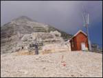 2
2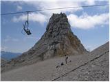 3
3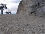 4
4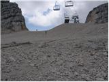 5
5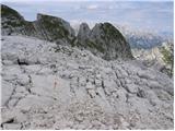 6
6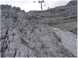 7
7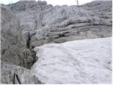 8
8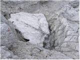 9
9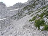 10
10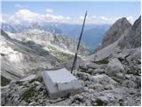 11
11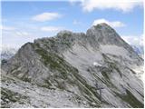 12
12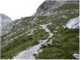 13
13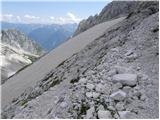 14
14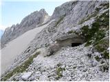 15
15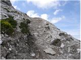 16
16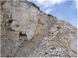 17
17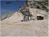 18
18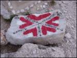 19
19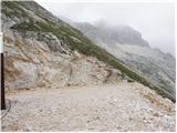 20
20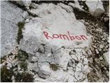 21
21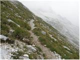 22
22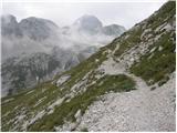 23
23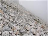 24
24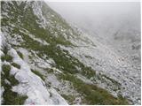 25
25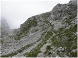 26
26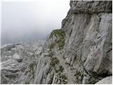 27
27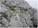 28
28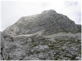 29
29 30
30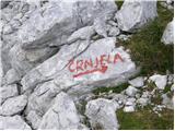 31
31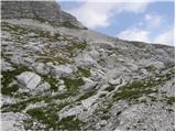 32
32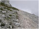 33
33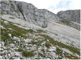 34
34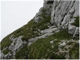 35
35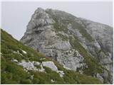 36
36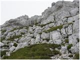 37
37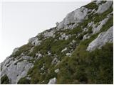 38
38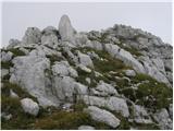 39
39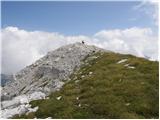 40
40 41
41
Discussion about the trip D postaja - Velika Črnelska špica
|
| mojcag11. 08. 2008 |
The hike is pleasant. It's a pity that you descend a lot from station D and then face an ascent on the way back, which is quite strenuous for tired legs.
The cable car to Kanin operates from 7:00 to 17:00 every full hour, so you have to make sure you're back by 17:00!
|
|
|
|
| triglavski12. 08. 2008 |
You don't need to return to D station, from Črnelška špica you can descend through Rupa to Planina Goričica and into the valley, or back to Prevala and below Krnica valley to B cable car station, another option is directly to the valley.
|
|
|
|
| ajo6230. 09. 2011 |
does anyone know the crossing from bivouac Savoia at saddle Robon to the ridge under the little Črnelska špica?
|
|
|
|
| ljubitelj gora21. 12. 2015 |
Yesterday 20.12 from B station towards Pl. Krnica and further up to the fork where the mule track branches right, and a bit further straight ahead not left. I follow it under the wall of Vratni vrh and when I reach the other side I look for the continuation of the trail up the valley. First I climb up the western side to Plešivec, then from the top continue to Vrtani vrh, Jelenk, Pri Banderi. Here I take a longer break and later decide to go to Velika Črnelska špica via the marked trail. After returning from Črnel.š. I descend via the mule track to Krnica and back to B station. Web album: https://picasaweb.google.com/114400986607884783562/PlesivecJelenkPriBanderiVelikaCrnelskaSpica
|
|
|
|
| mirank12. 06. 2017 |
Practically the same tour (but in the opposite direction) starting a little above B station we did yesterday. The overgrown military paths are somewhat more and somewhat less traceable here and there, but there are no major problems with orientation and passability. Otherwise, a beautiful tour, mostly on open terrain; except for two chamois we didn't see a living soul....
Our original plan was: cable car to "B" then via Krnica to Črnelo and via Rombon to Bovec, but we changed it because of the "flexibility" of the ticket seller. Maybe we are stingy, but it's incomprehensible to me that they have a price to B only for down (5eur), while for up you have to pay to "C" which is practically the whole (12eur) . Not even a taxi would cost me almost 50eur for those few kilometers of gravel. . Not even a taxi would cost me almost 50eur for those few kilometers of gravel.
|
|
|
|
| keti113. 06. 2017 |
I'm interested in the descent through Rupa? Is the path well traceable? Are there any major difficulties?
|
|
|
|
| mirank13. 06. 2017 |
As I wrote, we didn't descend through Rupa, so I wouldn't comment on the current condition of that path. But what you'll see from the top and also the junctions below, it will be immediately clear to you that the path is easy and unmistakable.
|
|
|
|
| keti113. 06. 2017 |
Thanks, it's clear to me where you went. I would like an answer from someone who has walked there recently
|
|
|
|
| keti125. 07. 2018 |
Yesterday we did the tour D station-Velika Črnelska špica-descent to Bovec through Rupa. The turn-off to Rupa is less visible, but if very attentive, you find it (when main path starts ascending to Rombon, big cairn). Many faded markings and cairns on path, easy to follow, starts in rocky world, very scenic, then about 1 hour above Pl. Goričica increasingly overgrown, grass to shoulders, rocks underneath, great caution needed. From Pl. Goričica on no problem. Descent very strenuous, ca 1900m drop, path requires attention. Definitely interesting experience. Ascent <3.5h, descent 5.5h.
|
|
|
|
| link_5. 08. 2018 |
Did anyone by chance pay attention and see on crneli the zig?
|
|
|
|
| BT885. 08. 2018 |
There was OZ. Why wouldn't there be?
|
|
|
|
| link_6. 08. 2018 |
Because some idiot would push it like on half of the other peaks. Thanks for the info.
|
|
|
|
| Jakacius29. 08. 2018 |
Yesterday I was there.
The stamp is in Aljažek, chained.
|
|
|
|
| darinka43. 09. 2018 |
On the Goričica pasture or a little further ahead there is a signpost that is already quite weathered where it says to go left to V. Črneljska špica, straight ahead to Rombon. Three hours to Črneljska špica. I wonder what the path is like, if it is still traceable?
|
|
|
|
| lijaneja3. 09. 2018 |
Darinka, the peak is Črnelska
|
|
|
|
| darinka43. 09. 2018 |
Yes, thanks for the warning.
|
|
|
|
| cebelca4. 09. 2018 |
Darinka, I went on this path last August, from top to bottom though. The upper part of the path is great, rocky, you walk over/past boulders, scree, very nice, such a varied karst world. Once you reach the grass belt, the ordeal begins. Everything overgrown, pushing through even over a meter high undergrowth and nettles, and that lasted more than an hour, a bit up, a bit down, no end or edge. True, we had a long tour behind us and it was dragging already because of that, plus heat and lack of water added their part. Nevertheless, once and never again, as far as I’m concerned.  Regarding traceability... I’d say perhaps only the initial 100 elevation meters above the pasture are a bit more problematic, at least we got a bit lost there. Maybe easier from top down. The higher you are, the harder to stray from the path. At least last year it was like that. Maybe better this year... maybe worse. Good luck. Regarding traceability... I’d say perhaps only the initial 100 elevation meters above the pasture are a bit more problematic, at least we got a bit lost there. Maybe easier from top down. The higher you are, the harder to stray from the path. At least last year it was like that. Maybe better this year... maybe worse. Good luck.
|
|
|
|
| darinka44. 09. 2018 |
Thanks cebelca. Still interesting that someone goes on this little-visited path to Črneljska špica.
|
|
|
|
| cebelca4. 09. 2018 |
Yes, it was more of an emergency descent than a planned path. The original plan was to continue to Rombon, but it didn’t work out and we turned down early.
|
|
|
|
| keti14. 09. 2018 |
Hi, end of July this year we descended from Črneljska špica via Rupa to pl. Goričica and down to Bovec. The path in the lower "green" belt above the pasture is really very overgrown, grass reaches up to shoulders in places, underfoot (where you see nothing) are stones, rocks, so had to step carefully and slowly not to injure your ankle. Followable at cairns and faded markers but you really have to be attentive all the time not to miss it. I’d say even harder to follow upwards. We took 5.5 hours from the top to Bovec (to A station), for the full ascent you can reckon at least 7 hours. Up we went by gondola and on foot from D station (took 3.5 hours). On foot from Bovec and back is really long and I wouldn’t recommend it unless really fit. But you can go up it and then take the gondola (check when the last one runs beforehand). Despite the length and effort it was a great adventure Good luck!
|
|
|
|
| dprapr4. 09. 2018 |
Isn’t it better from station B via planina Krnica and under Lopa to Črneljska špica?
|
|
|
|
| darinka44. 09. 2018 |
Great, bravo to both. Thanks.
|
|
|
|
| mirank4. 09. 2018 |
Drago, no need to go under Lopa, but about 100m above pl Krnica turn sharply right onto a trodden path. This leads you to the saddle between Pri banderi and the main ridge along a clearly visible mulattiera that climbs under the side ridge (which is always to your right above you). At the aforementioned saddle you pick up the marked trail and follow it through the labyrinth of scree to the boulder with the inscription Črnjela....
A beautiful return is via Pri banderi to Vratni vrh-all along Italian army positions and an easily followable mulattiera. Descent with the help of quite dense cairns across the eastern slopes of Vratni vrh or even easier via the intermediate gully where there is an easily followable path, here and there also steps. At the bottom you step onto a clearly visible mulattiera that descends towards Bovec; somewhere at the height of the first trees there are two paths to the right that lead back under the cliff barrier of V. vrh to the slopes 200m above pl Krnica.
The path, I think in the opposite direction, was most beautifully photo-documented by @Funnyboy under current conditions already about a year ago...
|
|
|
|
| dprapr4. 09. 2018 |
Isn't that under Lopa? That's exactly the saddle I meant.
I've already walked that variant over Vratni vrh, in fog. This "path" is even better, but I didn't suggest it because it's more pathless. But it's very interesting along those ledges, former army positions. And to approach this ridge even a bit higher, behind Vratni vrh.
|
|
|
|
| mirank4. 09. 2018 |
The mentioned path runs somewhere in the hollow of Hudega or Grdega vršiča. Lopa is to the left, Črnjela to the right in the main ridge; it is true that Lopa is always in front of our eyes. I don't doubt that you know the area well, but since the area is interwoven with a multitude of more or less visible paths, some marked ones too, the note was understood as it was. And one more thing, this year the mentioned paths (especially the return) are quite well trodden-better than last year.
|
|
|
|
| darinka412. 09. 2018 |
Yesterday 11.9. we headed to Velika and Mala Črnelška špica from Zavrzelno. Regarding the path from planina Goričica we had no problems. Otherwise the markings are quite faded. It shows that few people go here. The tour itself is worth all the effort. With viewing bunkers and remains from WWI. We returned the same way. We walked a good 12 hours. To the summit 1900m elevation gain.
|
|
|
|
| darinka47. 04. 2019 |
This year repeat when snow melts. Really one of those tours that stays in memory forever. Just need good weather without fog and rain. And if markings renewed it'd be perfect. Last year on descent missed slightly, went 300m toward Rombon missing the marked but poorly visible turnoff if not careful.
|
|
|
|
| haridautovic26. 06. 2020 |
Today we did this tour, specifically from station B of the Kanin cable car, past Planina v Krnici and along the marked path towards the pass. After 20 minutes, a well-followable path branches off to the right to Smreka. We follow this path for about 300 meters and then leave it again, heading left onto a fairly well-followable little path (today we repaired it and added extra cairns) for easier followability. This little path takes us to the cirque at 1890m asl where it joins the marked path from Kanin - station D. So the route proceeds without issues all the way to the summit. For descent, we chose to go over Mala Črnelska Špica through all the bunkers along the ridgelet and descended near the Speleološki Bivak onto the marked path to Rombon. We followed this path for about 200 meters; when it starts ascending, at a larger cairn the path branches right through a gap towards Planina Goričica. The path is fairly followable but very overgrown with faded markers. Above Planina Goričica, we left the marked path leading to Bovec and headed right along the mulatjera towards Roglje, aiming for Planina v Krnici and station B. Below the foot of Roglje, a nice mulatjera initially branches right, which gradually turns into a path crossing the entire grassy and forested terrain all the way to Smreka and Planina v Krnici, back to the starting point. Good 7h 30min and 18km.
|
|
|
|
| 12a3bc31. 05. 2022 15:20:55 |
Hello, I'm interested if there is a path between the summits Velika Črnelska špica - Hudi Vršič - Konjske police - lopa - Golovec - Prestreljeniški vršiči? Are these summits accessible or only alpinistic ascents? 
|
|
|
|
| darinka431. 05. 2022 15:43:21 |
I can tell you about the Črnelske špice. They are nicely passable. Lopa is a climbing ascent. If you master climbing, it's doable.
|
|
|
|
| rokeg1. 06. 2022 08:34:04 |
There are no marked paths between the mentioned peaks. The ridge is for alpinists. I think it's up to III. degree of climbing. Each mentioned peak individually is doable. In my opinion, Lopa is the hardest. To Hudi Vršič from the direction of the peak Pri Banderi. Rocks and steep grass. Lopa and Konjske police have descriptions on hribi.net. To Konjske police is about 10 minutes off the path. Golovec and Vršiči pod Lopo are fairly easy. Prestreljeniški Vršič can be reached from the path between Prevala and Škrbina pod Prestreljenikom. But there is quite steep grass on it.
|
|
|
|
| darinka427. 09. 2023 08:38:01 |
After five years up there. This time from planina Krnica. Along the already at least this year known path below Vratni vrh, Plešivec and Pri Banderi. Along the way we climbed the last unnamed peak in the Bandera group. Then for a while along the path leading to Rombon. All the way to the junction for Črnelske špice. On Hudem Vršiču there were two hikers visible. Likewise, two set off in the morning to Plešivec and then also to Velika Črnelska špica from planina Krnica. We descended from Mala Črnelska špica along the ridge all the way to the end. There we found the path to the one leading to Rombon. And at the clearly visible junction, further from the cavers' bivouac, we turned towards Zavrzelno. On this path they have renewed the markers because it is a hiking trail. Just before Goričica we turned onto an unknown path for us that goes under Roglje. Initially through the forest. We were happy about how beautiful it is. Then quite some steepness. In tall grass where the path got lost. And reached the junction for Plešivec. Then the last part to planina Krnica. Water flows a bit lower there where the path to Rombon branches off. A beautiful long and especially interesting tour.
|
|
|
To post a comment you must log in:
If you do not yet have a username, you must first
register.