Cristo di Forca - Amariana
Starting point: Cristo di Forca (1050 m)
| Latitude/Longitude: | 46,39046°N 13,07216°E |
| |
Walking time: 2 h 30 min
Difficulty: partly demanding marked way
Elevation gain: 855 m
Elevation difference along the route: 900 m
Map: Tabacco 013
Recommended equipment (summer): helmet
Recommended equipment (winter): helmet, ice axe, crampons
Views: 18.858
 | 4 people like this post |
Access to starting point:
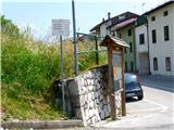
From Ljubljana on the Gorenjska highway, exit Hrušica, continuation over the border crossing Rateče to Trbiž. There we turn onto the highway, which we leave at exit Tolmezzo. In the roundabout immediately after the toll station, we turn right at the second exit and follow the signs towards the village Amaro. At the beginning of the village, there is a smaller park by the road and there we turn left. We continue straight to the crossroad, where there stands a sign with a map and signposts (photo). We drive ahead in the direction of path 414 on a narrow asphalt mountain road to the mountain pass Cristo di Forca at an altitude of 1058 m. We park on the parking lot, which is situated a little ahead from the saddle and has space for approx. 20 cars. The road is very narrow and winding, so it is wise to keep an eye on the passing places in case we encounter another vehicle. For the entire route from Ljubljana to the parking lot, we need 2 hours.
Route description:
Just before the saddle there is clearly visible and marked the beginning of the path 414 towards Amariana. A nicely routed path at the beginning runs through a sparse forest. We are continuously ascending, but the feeling of steepness is never too great. After an hour of walking, the path opens up, as we pass onto grassy slopes. Views also open up on wide scree fields at the foot of the mountain and traffic arteries that run alongside them. The path over the slopes continues to rise and slowly we come to a rocky gully. Here steel cables begin, which assist in the ascent over the rocky step. The ascent over this step itself is not particularly problematic as the steel cables primarily serve as support against slipping.
When the steel cables run out, we are already in the notch between two peaks. Amariana is on the left side; you can also visit the right one, as it has a modest path to the top. Our peak is a good 15 minutes away, and the path runs along the ridge. On the top stands the obligatory statue of Mary, which is additionally illuminated here with energy from solar cells. The view from the top is outstanding in all directions with good visibility, as Amariana has an exposed position above Tolmezzo.
Return is along the same path.

Photos:
 1
1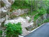 2
2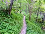 3
3 4
4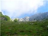 5
5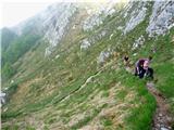 6
6 7
7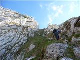 8
8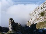 9
9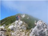 10
10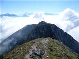 11
11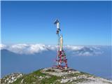 12
12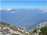 13
13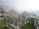 14
14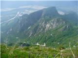 15
15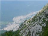 16
16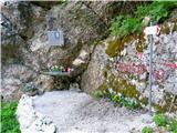 17
17
Discussion about the trip Cristo di Forca - Amariana
|
| grega_p8. 06. 2010 |
Thanks Bagi for this description - nice hike, scenic and definitely not recommended for summer days.., I experienced that on a hot July day.
I didn't have enough water for myself when two dogs appeared at the summit next to the statue of Mary, all shaggy and dehydrated. I don't know who left them there, but it surely wasn't for a good reason. I decided to take them down to the valley - I carried one across the wire ropes, the other somehow made it down the steep parts. Along the way we sipped drops and ate raspberries (the dogs too!). The odyssey ended after 3 hours at the car, after which I took them to the shelter in Tolmezzo..
Yes, such things happen in the mountains too.
|
|
|
|
| bagi8. 06. 2010 |
Hi Grega. You're right. We started hiking at 5:30 and towards the end of the return the sun was already showing its power. There was no heat on the ascent due to the early hour, and fog also covered the sun for us. Too bad you had such an experience, as the mountain is definitely interesting. Let me tell you, we met some mountain runners on the trail. Of course they were running  , but they passed us as if someone was chasing them. The oldest among them was well over 60, and he had only one small bottle of drink with him , but they passed us as if someone was chasing them. The oldest among them was well over 60, and he had only one small bottle of drink with him 
Regards Bagi
|
|
|
|
| VanSims2. 10. 2010 |
The name of the pass where we start is also written on the sign in Amar FORCA DEL CRISTO. When driving up the road to it, we must also watch out for hikers and runners whom we might easily overlook due to the narrow path and bends.
The parking up there is enough for about 10 cars and even those would have to park really tight. 
Otherwise, this tour borders on demanding in my opinion. The climbing section with cables isn't exactly simple for a beginner even though it's true it's not exposed. The path to the cables themselves really isn't too steep.
|
|
|
|
| tisa19. 12. 2010 |
Grega p, all praise because you took such good care of both dogs.
Best regards and good luck
|
|
|
|
| atoamac19. 12. 2010 |
I suggest to the administrators to correct the slip with the starting point name, as noticed by VanSims. Now it's similar to saying Sedelski Kamnik instead of Kamniško sedlo.
|
|
|
|
| IgorZlodej20. 12. 2010 |
The correct name of the starting point is Cristo di Forca (1058, Carta Topografica no. 013). Ascent to the summit via path 414 and descent back is not a particular feat, and it's short too. With my friend, we descended by crossing the entire eastern ridge to Ric. Monte Forcella (1098, path 415) and down to the Val Beli near the road bridges about a km or two east of the village of Amaro. Of course, we had two cars, because walking back to the starting point at Cristo di Forca would be too much.
|
|
|
|
| mirank23. 12. 2010 |
What Igor wrote holds true only that my wife and I descended via the ascent path. I don't recall any more demanding spots but indeed in the upper part of the path where there are cables there was some snow in places and it required a bit more care because of that. Nice short tour for a short November day last year.
|
|
|
|
| VanSims24. 12. 2010 |
Igor, I believe for you experienced mountaineer the mentioned path was a piece of cake. What I wanted to point out is that the climbing section isn't exactly for a complete beginner.
As for the name that's just how it was written on the signpost. Maybe it's two variants of the same name. Should ask someone from there. Perhaps Alessio would know?
|
|
|
|
| krsto713. 08. 2012 |
I agree with VanSims... with my wife we have quite a few years of experience with such and other ascents... Monte Amariana is a very beautiful and panoramic mountain, the trail in the lower part is not difficult. But regarding the climbing part, someone who is not used to such trails (especially a beginner) will actually have big problems... Great caution is needed, because rocks can easily break off, and you need to look well what you grab onto. We had several cases where we grabbed a rock or cliff, and something remained in our hand... Otherwise, the trail, if you have experience and are not afraid of heights, does not present special difficulties, but for beginners I recommend before visiting the mentioned mountain that they first try some easier and especially shorter climbing variant...
|
|
|
|
| Janiel7431. 05. 2015 |
Has anyone been on this path recently?
Since I haven't been in these parts yet, the Karnijci tempt me, is any vignette etc. needed for these areas? Thanks
|
|
|
|
| klm31. 05. 2015 |
Vignette? If you go along the main road SS13 you don't need any vignette.
The path is pb.
|
|
|
|
| bagi31. 05. 2015 |
@Janiel74 .... I strongly recommend the motorway. The main road has countless speed limits through settlements. The motorway is direct, you don't need a vignette. Payment is at the toll booth, last year from Trbiž to there it was approx 6 €. You have the description where and how in Tolmezzu on Hribi.net
|
|
|
|
| Janiel7431. 05. 2015 |
Thanks I need to get a bit settled in these parts. Until then, I'll ask some more.
|
|
|
|
| IgorZlodej31. 05. 2015 |
If the road is already a problem, there will be even more questions , and you don't even need Tolmezzu, because the starting point is Amaro 
|
|
|
|
| atoamac19. 10. 2020 |
Currently, the intersection shown by No. 1 is dug up, continue straight to the end of the village, detour marked. The climbing section has been equipped with safety gear since 2016 (10 sections of steel cable). Yesterday there was just enough snow to wet the shoes.
|
|
|
|
| winni21. 05. 2023 19:38:51 |
The path by difficulty definitely falls under difficult, but on this portal these subjective ratings are completely irrelevant. In the upper part there are about 10 fixed ropes and at least half are really not there for nothing.
At the starting point there is a new difficulty sign, marked as EEA, on another sign they recommend full self-belaying (in 4 languages, including Slo).
|
|
|
|
| polownk199813. 04. 2024 11:45:12 |
Hello,
Has anyone been in this area recently and can say if there's still any snow on the path?
Thanks and best regards
|
|
|
|
| Hribovkatinca11. 05. 2025 18:40:44 |
I would just add that I recommend a helmet on this trail... because the gully is quite crumbly
And of course via ferrata gloves are not superfluous
Because if it's damp on the climbing section it gets slippery and gloves come in handy
Otherwise it's a nice trail that ascends nicely zigzagging all the way to the gully
In the gully
Some knowledge and caution are needed
|
|
|
|
| mirank11. 05. 2025 21:14:30 |
On Krn I've already seen someone with a helmet coming from the direction of Kuhinja, but not yet on Amariana . Well, it's true that I haven't been there as often as on Krn . Well, it's true that I haven't been there as often as on Krn oh, we're talking dry conditions so no mistake. oh, we're talking dry conditions so no mistake.
|
|
|
To post a comment you must log in:
If you do not yet have a username, you must first
register.