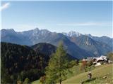
Bukovnik - Lanež (Hojnikova pot)
Starting point: Bukovnik (1327 m)
| Latitude/Longitude: | 46,434°N 14,7371°E |
| |
Route name: Hojnikova pot
Walking time: 2 h
Difficulty: difficult unmarked way
Elevation gain: 598 m
Elevation difference along the route: 600 m
Map: Grintovci 1:25000, KSA 1:50000
Recommended equipment (summer): helmet
Recommended equipment (winter): helmet, ice axe, crampons
Views: 9.063
 | 3 people like this post |
Access to starting point:
We drive to Luče (to here from Mozirje or via Kranjski rak) and follow the road ahead towards Logarska dolina, but only to the village Solčava, where we turn right towards Podolševa and Črna na Koroškem. The ascending road eventually brings us to a crossroads, where we turn right in the direction of Črna. Higher up, the road brings us to a crossroads at the mountain pass Spodnje Sleme. Here we turn right in the direction of the Koča na Grohatu and Bukovnik. Soon we come to the next crossroads, where to the left (straight ahead) branches off the traffic-closed forest road to Grohat. Here we park on one of the smaller parking areas by the road.
Route description:
From the parking lot, we head onto the upper left road, which already after a few tens of meters crosses the barrier. A little further on, we reach the spot where a footpath branches off to the left upwards, onto which we turn. The path first ascends slightly, then mostly in a gentle ascent crosses the slopes towards the south. During the crossing, we cross a large number of gullies and some steeper slopes. In places, a small wooden bridge even helps us. After a good half hour of walking, we emerge from the forest onto a forest road. Only a few steps of gentle ascent to the Koča na Grohatu follow.
At the hut, we head straight gently upwards towards the forest. We find the sign marking the start of the path on a tree and climb over the pasture fence onto the path, which runs left upwards. We follow this relatively easy-to-follow path through the forest to a smaller saddle at approx. 1600 m altitude. At the saddle, we turn right and on an increasingly less visible trail begin the ascent below the cliffs of Lanež. The path goes in places in zigzags steeply upwards and brings us below the most difficult part - the gully. Here we put on our helmets, as the gully is loaded with scree.
The ascent through the scree-filled gully is quite demanding (sections of 1st grade), and remnants of the formerly secured path (pitons and staples) assist us. At the exit from the gully, a short very steep ascent on grass awaits us, from where it is only a couple of steps to the summit of Lanež.
Descent via this path is even more demanding, so I recommend descending via the newly constructed path over Durce!

Along the route: Koča na Grohat (1460m)
Photos:
 1
1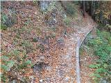 2
2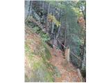 3
3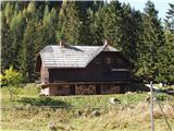 4
4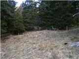 5
5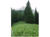 6
6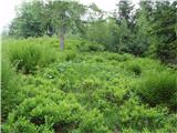 7
7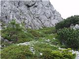 8
8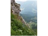 9
9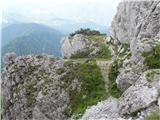 10
10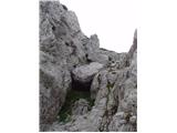 11
11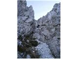 12
12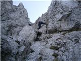 13
13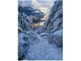 14
14 15
15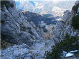 16
16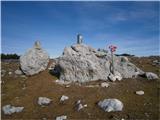 17
17
Discussion about the trip Bukovnik - Lanež (Hojnikova pot)
|
| neph7. 07. 2013 |
Since the trail description is on this portal, visits to Hojnikova pot have certainly increased, at least judging by the summit logbook at Lanež 
|
|
|
|
| pohodnik387. 07. 2013 |
I noticed there are quite a lot of entries, true also that those going to Raduha from Grohat still detour to Lanež as it's 10 min off the trail.
|
|
|
|
| neph8. 07. 2013 |
Certainly, many people don't sign in either. But I meant the entries where they explicitly state that they came via Hojnikova pot.
|
|
|
|
| montura20. 05. 2015 |
Yesterday we walked this path very carefully and concentrated, helmet mandatory!
On the ledge at the second bracket, orange sunglasses were left  , if/when someone finds them, politely asked to report or leave them at Bukovnik . , if/when someone finds them, politely asked to report or leave them at Bukovnik .
|
|
|
|
| mpp18. 07. 2015 |
alternative DESCRIPTION:
From Bukovnik we go to the access road leading to the hut at Grohot and then immediately up the steep rocky gully towards the ridge, after a ravine the gully levels out and turns right through scree, there we turn left steeply uphill on the footpath. The path takes us to Prosenčev vrh. Then just follow the occasionally quite overgrown path along the ridge. Wonderful views. After a while it joins the above-described path from the hut.
When we reach below the wall, keep to the right. Faint, faded markers (arrows) help. Description of the climbing part is above.
Nice trail, solitary
Where is the mentioned logbook?
Unfortunately I didn't have pruning shears with me, they would have been useful on certain sections.
|
|
|
|
| pohodnik3820. 06. 2016 |
Some snapshots from Saturday's ramble on this path. It was excellent, would have been even better if I didn't have to hurry because of forecasted showers-thunderstorms. The terrain was just soaked from daily rain.
PICTURES and personal impressions from the path
Regards! Tone
|
|
|
|
| garmont10. 06. 2018 |
The trail in the lower part, from the crossing of the pasture fence onwards, is impassable due to fallen trees.
Better to head off-trail to the formerly marked ridge earlier.
There are also some large fallen trees on the ridge and considerable gymnastics is needed to get through them.
|
|
|
|
| zokipoki16. 07. 2019 |
Today to Lanež via Hojnikova. The path from crossing the pasture fence to the saddle, at three spots still somewhat difficult to pass, but with a bit of gymnastics it doesn't cause problems. In the gully itself no special features.
|
|
|
To post a comment you must log in:
If you do not yet have a username, you must first
register.