Bohinjsko sedlo - Črni vrh (above Soriška planina)
Starting point: Bohinjsko sedlo (1277 m)
| Latitude/Longitude: | 46,2409°N 14,01°E |
| |
Walking time: 1 h
Difficulty: easy unmarked way
Elevation gain: 209 m
Elevation difference along the route: 250 m
Map: Škofjeloško in Cerkljansko hribovje 1:50.000
Recommended equipment (summer):
Recommended equipment (winter): ice axe, crampons
Views: 3.881
 | 1 person like this post |
Access to starting point:
A) From the Ljubljana - Jesenice highway, take the Lesce exit and follow the road towards Bled and then towards Bohinjska Bistrica. From Bohinjska Bistrica, continue left in the direction of Tolmin and Soriška planina. Follow this road to a large parking lot near the ski center Soriška planina.
B) From Železniki, drive towards Podbrdo or vice versa, but only to the spot where signs for Soriška planina direct us onto an ascending road. Follow this road to a large parking lot at the foot of the ski slope Soriška planina.
Route description:
From the parking lot below the ski center Soriška planina, continue on the asphalt road towards Železniki and Podbrdo. Soon, i.e. after approximately 50 m, we will notice signs for Ratitovec and Zgornje Danje on the left side of the road, which direct us slightly left onto a marked footpath; this first descends along a cart track, then turns left and changes into a somewhat harder to follow path. The path further leads us across a larger grassy clearing, behind it we cross a strip of forest, then it brings us to another clearing, where we step onto a wide cart track. We follow the cart track to the right and walk along it to the nearby road, which we reach right at the lower part of a short asphalted section. When we step onto the road we go left and first ascend, then gradually begin to descend. When the road stops descending, we leave it and continue left onto an unmarked cart track, which begins to ascend moderately. Higher up the cart track splits a few times, and we choose the slightly left branches.
When the cart track higher completely flattens out, we join a macadam road, which we follow to the left, and it immediately makes a right hairpin bend. We ascend along the road for a few minutes, then go left from it onto a forest cart track, along which we ascend to the indistinct ridge of Črni vrh. There follow a few minutes of walking along an occasionally panoramic ridge and we reach Črni vrh; for a better view, it is worth walking around the summit.
Description and pictures refer to the condition in 2019 (January).

Photos:
 1
1 2
2 3
3 4
4 5
5 6
6 7
7 8
8 9
9 10
10 11
11 12
12 13
13 14
14 15
15 16
16 17
17 18
18 19
19 20
20 21
21 22
22 23
23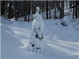 24
24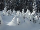 25
25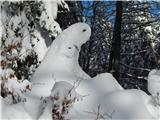 26
26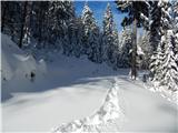 27
27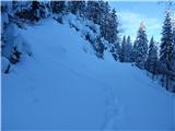 28
28 29
29 30
30 31
31 32
32 33
33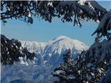 34
34 35
35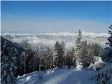 36
36
Discussion about the trip Bohinjsko sedlo - Črni vrh (above Soriška planina)
|
| ločanka7. 02. 2022 11:43:07 |
Now you can also choose the third access option, namely along the new track above the cross-country ski trails (behind the parking lot). A really attractive peak at this time when the landscape is covered in snow. Yesterday we first noticed signs on the parking lot for parking fees for those who don't buy a ski pass, namely 2 euros. It seems this is now all the rage! As if I hadn't noticed it . .
|
|
|
|
| jprim7. 02. 2022 17:24:36 |
Nice trip.
Well, I wouldn't say it's modern, but it's about time we start charging for parking and of course the use of roads that take you a bit higher here too. We've been used to it with our neighbors for a long time, no one comments if you have to pay.
LP!
|
|
|
|
| turbo7. 02. 2022 18:59:02 |
Well, with our neighbors (Carnic Alps) in the last ten years before corona I didn't spend as much as I would in one day if I parked at Blato. Actually, I spent less than a coffee costs anywhere here, since I didn't spend anything on parking. Steep and narrow roads, sometimes barely wider than a car, lead high under the peaks, few are still gravel, often at the end there's an arranged parking lot, a bench and table, not rarely a panorama sign.
|
|
|
|
| palček plezalček7. 02. 2022 19:09:45 |
I wouldn't say that our neighbors are so used to it. Upon reflection, I can't recall a road or parking lot in the Julian Alps that I had to pay for, nor in the Carnic Alps. In the Dolomites, I remember the terribly expensive toll road (+ parking), but it leads to the 'world wonder' called Tre Cime. Surely there are quite a few toll roads (in Austria I remember some private ones or e.g. Großglockner Hochalpenstraße etc.), but in principle I don't know that roads or starting point parking lots are self-evidently paid everywhere. After all, we pay road contributions, taxes..., with which roads are built, maintained and upgraded. It's right to pay for private roads because the owner maintains them, and we destroy them with use.
|
|
|
To post a comment you must log in:
If you do not yet have a username, you must first
register.