Bistriška planina - Šentanski vrh
Starting point: Bistriška planina (1057 m)
| Latitude/Longitude: | 46,3797°N 14,2741°E |
| |
Walking time: 1 h 35 min
Difficulty: easy marked way
Elevation gain: 578 m
Elevation difference along the route: 590 m
Map: Karavanke - osrednji del 1:50.000
Recommended equipment (summer):
Recommended equipment (winter):
Views: 20.736
 | 3 people like this post |
Access to starting point:
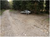
From highway Ljubljana - Jesenice we take the exit Ljubelj and follow the road ahead in the direction of Tržič. Just before the gas station at Tržič we turn right (direction Tržič) and then immediately left (direction Begunje) and we drive further to the village Brezje pri Tržiču. In the village Brezje pri Tržiču, on the top of the slope, we turn right towards Bistriška planina. After approximately 100 meters we come to the junction, where we turn right on the forest road. The road, which further ascends quite steeply, brings us to Bistriška planina after a while, where we park on the parking lot by the road (Brezje pri Tržiču - Bistriška planina 3.1 km, of which 2.6 km macadam).
Route description:
From the parking lot at Bistriška planina we continue on a macadam road which after a short ascent brings us to Breška planina, which we recognize by a wooden cottage. The worsening road then brings us to a junction, where we continue right on a steep cart track in the direction of Lešanska planina. The cart track up which we then ascend has some junctions, but if we follow the blazes it brings us to the mentioned mountain pasture without any bigger problems, from which a nice view opens up on Storžič and Tolsti vrh.
On the mountain pasture, where there stands also a shepherd hut of open type, we have two options to continue. We choose the right one, which is a little shorter and more panoramic. The path which is a little poorly marked at first takes us to the eastern part of the mountain pasture, where it makes a left turn and then after a further few minutes joins the normal path to Dobrča. Here we continue sharply right and we follow the forest path to the top of Dobrča, where we notice a signpost for Šentanski vrh, which points us downwards to a small saddle between both peaks. Only a light ascent follows to panoramic Šentanski vrh, which we reach after a few dozen strides.

Photos:
 1
1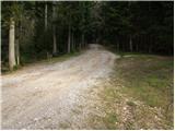 2
2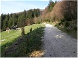 3
3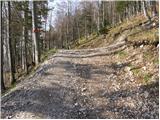 4
4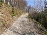 5
5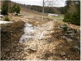 6
6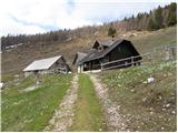 7
7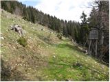 8
8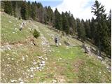 9
9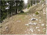 10
10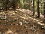 11
11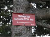 12
12 13
13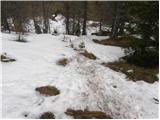 14
14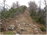 15
15 16
16
Discussion about the trip Bistriška planina - Šentanski vrh
|
| klavdipo7. 05. 2008 |
Is there also a stamp at Šentanski vrh??
|
|
|
|
| andrej jerina7. 05. 2008 |
This winter I made the ascent to the mentioned summit. The path is very nice and I recommend it also to families with children. There is also a stamp at Šentanski vrh. Šentanski vrh is for me one of the most beautiful viewpoints on Karavanke. Recommended! Best regards Andrej
|
|
|
|
| niki9. 05. 2008 |
Hello! I'm interested in what the road to Bistriška planina is like, can you drive there by car and how much snow is left on Dobrča summit or on Šentanski vrh? We'd like to go there on Sunday. Thank you for the answer. Niki
|
|
|
|
| andrej jerina9. 05. 2008 |
Niki, hi! The road to Bistriška planina is gravel, nicely drivable. You drive or climb the road until you see Bistriška planina on your right side. It might happen that you have to wait a minute on the road, as it is also used for timber extraction from the forest. Bobrča and Šentanski vrh are snow-free. Best regards Andrej
|
|
|
|
| Biser gora8. 08. 2008 |
Yesterday we went to Dobrča and at a friend's suggestion extended the trip to the nearby Šentanski vrh. It's really worth it, just 5 min. walk and you reach a magnificent viewpoint.
|
|
|
|
| tom66665. 07. 2009 |
Yes, great view yesterday from Šentanski vrh!
|
|
|
|
| Kokta10. 12. 2011 |
I agree with Andrej...magnificent vantage point..highly recommend.
|
|
|
|
| capraibex10. 12. 2011 |
I've also been to Šentanski vrh many times. An interesting path leads from Ljubelj over Prevala pasture, but it's long and rarely visited.
|
|
|
|
| kaanja17. 11. 2012 |
Today at Šentanski vrh on the stamp box I forgot my notebook (light brown color, hardcover), where I record conquered summits. If someone found it and took it to the valley, please contact me. Many thanks!
|
|
|
|
| Ursa511. 01. 2020 |
Has anyone gone up this trail these days? I'm interested in how much snow there is and what equipment is recommended.
|
|
|
|
| Kranj11. 01. 2020 |
Ursa just go for it, everything is BP.
|
|
|
|
| michael6631. 03. 2023 19:38:57 |
And who knows in what condition the macadam to Bistriška planina is.
|
|
|
|
| baloncek0521. 05. 2023 19:08:01 |
What's the road to the mountain pasture like? Can you go by car?
|
|
|
To post a comment you must log in:
If you do not yet have a username, you must first
register.