Belopeška jezera - Visoka Ponca (via normale)
Starting point: Belopeška jezera (929 m)
| Latitude/Longitude: | 46,4733°N 13,6713°E |
| |
Route name: via normale
Walking time: 4 h
Difficulty: very difficult marked way
Elevation gain: 1345 m
Elevation difference along the route: 1345 m
Map: Julijske Alpe - zahodni del 1:50.000
Recommended equipment (summer): helmet, self belay set
Recommended equipment (winter): helmet, self belay set, ice axe, crampons
Views: 40.720
 | 3 people like this post |
Access to starting point:
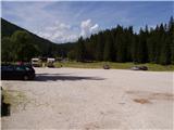
From Kranjska Gora over the border crossing Rateče we drive towards Trbiž / Tarvisio. Soon after the border crossing, the road in the direction of the Belopeška lakes / Laghi di Fusine branches off to the left, which in a moderate ascent we then follow to a large parking lot at the Upper Mangartsko (Belopeško) lake.
Route description:
From the parking lot, we continue on the left side of the inn in the direction of the mountain hut Zacchi. The path at first runs along the forest road, which we leave after a few minutes, because the blazes direct us to the left onto a wide cart track. The cart track along which we walk changes a little higher into an ascending footpath. The relatively wide and well-marked path then brings us in a moderate ascent through the forest in about an hour of walking from the starting point to the mountain hut Zacchi (to here also possible along the forest road).
At the hut we follow the signs »Ponza di Mezzo, Ponza Grande«. The path from the hut then ascends for some time through dwarf pines below the steep slopes of the Poncs slightly to the right and soon brings us to the first steel cables on the path. Here the path turns a little to the left and then ascends quite steeply several times along the steel cable. When we get completely close to the walls below Visoka Ponca, the path turns to the right and crosses a wide gully. A shorter ascent follows a little to the right of the gully, which brings us to a path junction. To the left branches off the direct very demanding climbing path (ferrata) to Visoka Ponca, and we head to the path on the right, which leads towards Srednja Ponca and to Visoka Ponca via a somewhat easier path. The path from the junction first crosses the slopes to the right in a gentle ascent, then turns to the left and ascends a steep grassy slope. The grassy slope is soon replaced by rocks and after a shorter ascent we are again at a path junction. This time we head left towards Visoka Ponca, to the right the path leads to Srednja Ponca and further to Tamar. The path then crosses the slope to the left and brings us to Planiška škrbina (2156 m), where for the first time a view opens to the Slovenian side into the Tamar valley. At the notch the path turns to the left and steeply ascends along the steel cable on a narrow ridge. The path then moves away from the ridge to the south side and first crosses the steep slope towards the northeast in a gentle ascent, then turns slightly to the left and steeply ascends the rocky slope towards the summit. In the last part towards the summit, the path is also slightly crumbly.

Photos:
 1
1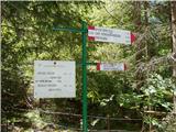 2
2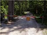 3
3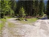 4
4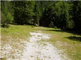 5
5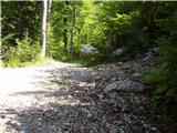 6
6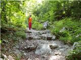 7
7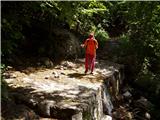 8
8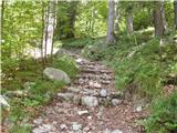 9
9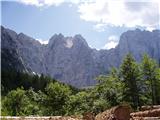 10
10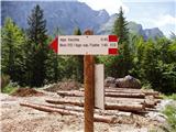 11
11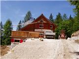 12
12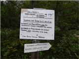 13
13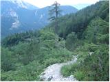 14
14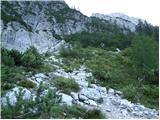 15
15 16
16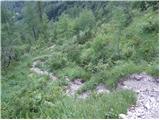 17
17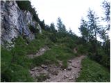 18
18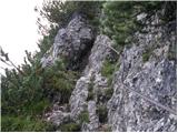 19
19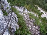 20
20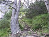 21
21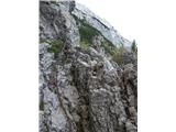 22
22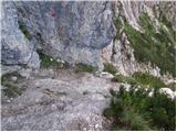 23
23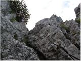 24
24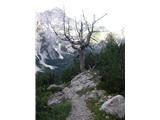 25
25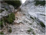 26
26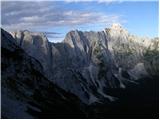 27
27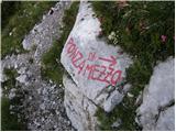 28
28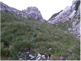 29
29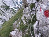 30
30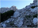 31
31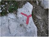 32
32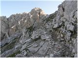 33
33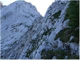 34
34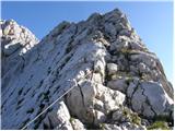 35
35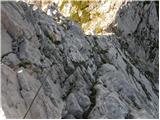 36
36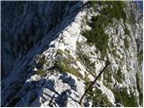 37
37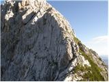 38
38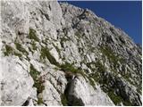 39
39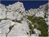 40
40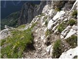 41
41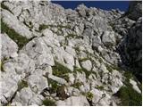 42
42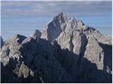 43
43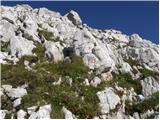 44
44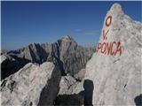 45
45
Discussion about the trip Belopeška jezera - Visoka Ponca (via normale)
|
| barjus13. 08. 2009 |
Has anyone gone up the via ferrata recently? Are the protections in good condition?
|
|
|
|
| zlatorog16. 08. 2009 |
Yesterday 15.8 we went via the Alla via ferrata to Visoka Ponca then to Srednja Ponca and then back to the valley. Safety gear on the via ferrata OK, watch out for loose rocks on the path.
Recommended! 
|
|
|
|
| nisa1. 09. 2009 |
What is the condition of the fixed protection on the path from Tamar to Srednja and Visoka Ponca?
|
|
|
|
| Matjaz_6529. 07. 2010 |
or does anyone know ... what condition the ferrata is in ... or if it's open 
|
|
|
|
| Matjaz_6529. 07. 2010 |
thanks :-)
I forgot about current conditions 
|
|
|
|
| Matjaz_6514. 08. 2010 |
On my photos there is the ascent via ferrata with passage over Planiška škrbina to Srednja Ponca 
|
|
|
|
| rs75617. 08. 2010 |
I'm interested in the tour: Zacchi, Visoka, Srednja, Zadnja Ponca and descent to Zacchi hut.
Time-wise, this or the reverse variant.
Thanks
|
|
|
|
| dropkykite11. 08. 2011 |
Walked today - Zacchi, high and middle Ponca, descent to Zacchi (time-wise we used 7 and a half hours). No snow, path well secured, just need to watch the rocks underfoot. Recommend helmet use.
|
|
|
|
| anjazan12. 07. 2013 |
Has anyone gone this route recently, what are the conditions like.
thanks
|
|
|
|
| evgenc13. 07. 2013 |
I'm also interested in the conditions
|
|
|
|
| masu15. 07. 2013 |
I was there yesterday. Up on ferrata, down Ponca Skrbina and normal way of Srednja Ponca. No snow, via ferrata is well equipped. Be careful between Visoka Ponca top and Ponca Skrbina because of very exposed route and almost no ropes or other equipment and very crumbly route. 8 hours with pauses from Belopeška jezera and return. A route for "gams"...
Sorry for english but "Jaz govorim malo slovensko..." Zdravo!
|
|
|
|
| Joze Malina31. 07. 2013 |
On 31.7. I set off from Belopeška jezera, past koča Zacchi to Visoka Ponca via ferrata. The path to the ferrata from koča Zacchi is quite dynamic, so it doesn't drag on. The safety equipment is in excellent condition. Helmet and via ferrata set are mandatory, as the path is quite crumbly, and on the ferrata there's also a section that "pushes" you into the abyss and it's good if you're clipped in. Climbing-wise, the first 100 m of the ferrata are the most demanding. The continuation from a climbing perspective is not so demanding, but it seemed significantly more dangerous to me, as the path is indistinct and EXTREMELY crumbly, there are practically no red markers. You have to watch for "stone men" that mark where the path should be, but due to the overall indistinctness of the path, you need some sense of orientation. Once you stray from the path, returning through crumbly and precipitous terrain is unpleasant.
For descent from the summit of Visoka Ponca, in my opinion, the ferrata is SIGNIFICANTLY more suitable. I myself descended via Planiška škrbina, but I really advise against that path. The path is EXCEPTIONALLY crumbly, steep and precipitous, with NO safety equipment. 100% concentration and slow steps are required, as in case of a slip you tumble into a hole. The path to Srednja Ponca is in the same style - indistinct, poorly marked (if marked at all, it's faded), crumbly, no safety equipment, and the slopes are very steep. On the summit of Srednja Ponca there's also a quite worn stamp.
From Srednja Ponca I went to Zadnja Ponca as well. The path is marked as easy on my map, which is mostly true except for Rdeča škrbina. There are two old cables there that don't inspire much confidence, otherwise the path is again completely without safety equipment, which would be very much needed. The path is again very crumbly, narrow and dangerous for slipping. Further from the saddle it's no longer so dangerous, but on the summit of Zadnja Ponca I didn't find the stamp  . Despite the apparent closeness of Srednja and Zadnja Ponca, it takes a good hour for the round trip, as extreme caution is needed in Rdeča škrbina. . Despite the apparent closeness of Srednja and Zadnja Ponca, it takes a good hour for the round trip, as extreme caution is needed in Rdeča škrbina.
I descended from Srednja Ponca. The descent is awkward, as the old story repeats (except for the markers, which are frequent and clear) - crumbly, narrow, indistinct and unprotected path with steep grassy slopes (dangerous for slipping). When we join the path by which we ascended to Visoka Ponca, we can relax, as it's much better trodden (no longer so dangerous for slipping), and cables and scree appear, which provide good grip for hands. A relaxed descent to koča Zacchi follows, and then to Belopeška jezera. For the entire path I needed approx. 10 hours, of which 1 hour resting.
In short: I highly recommend the ferrata and Visoka Ponca to everyone who has no issues with climbing and vertigo. Everything else I strongly advise against, unless you intend to traverse the entire ridge from the very start. The described path is extremely demanding mainly from a psychological standpoint, because you have to maintain concentration for several hours to avoid slipping, and you also need some fitness, as the path is not short. In case of fog, stay in the valley, as orientation on indistinct paths is already non-trivial even in sunny weather.
|
|
|
|
| mukica2. 09. 2013 |
On Saturday we walked the Belopeška jezera path via ferrata to Vevnica-Strug and ridge traversed all Ponce and descended from Visoka via ferrata to koča Zacchi. Interesting and nicely varied path that forces you to be maximally focused and attentive to every step throughout the tour. I'd add that the ferrata from V.Ponca is nicely renovated, only the initial descent at the top is not marked with blazes, but cairns are nicely visible.. at some places slightly damaged or already torn (missing) need to follow signs carefully, as it's really crumbly and if you stray it can become difficult A bit different situation is the ridge from Vevnica to Strug and further to Ponce, that's another description... Safe steps to all
|
|
|
|
| acjom11. 07. 2014 |
Has anyone hiked towards Visoka Ponca? Interested in conditions, snow, fixed protection ..
|
|
|
|
| Robie16. 07. 2016 |
Nice path, hiked today. Protection damaged in a couple of places, upper part actually unmarked but can be followed with little difficulty by cairns. Otherwise as written, crumbly, self-belaying recommended and helmet mandatory - rocks are triggered a lot. But at koča Zacchi the sign for Visoka Ponca is a bit hidden and quite a few missed the path today
|
|
|
|
| redbull17. 07. 2016 |
On the normal route it's hard to need a harness, on the ferrata it's a different story.
|
|
|
|
| stzu5110. 08. 2016 |
Has anyone recently gone up the via ferrata? Are the fixed protections in good condition?
|
|
|
|
| redbull11. 08. 2016 |
The fixed protections are new, you don't see such ones at home. The Italians started renovating them in recent years
|
|
|
|
| andrej7811. 08. 2016 |
Super Grm, contra what do you know about our side?
|
|
|
|
| janez.novak11. 08. 2016 |
True, what the Italians are renovating now is really quality. On this ferrata the cable is torn at one spot, but it's replaced with a rope. But the Italians could make some pitons from the end of the cables, which would ease orientation.
|
|
|
|
| Miran Matičič1. 10. 2016 |
On 29.9.2016 I was on Visoka Ponca. I don't know who to report to that somewhere in the middle of the approach path to the junction for Visoka and Srednja Ponca, a broken off about 200 kg heavy rock is leaning on the steel cable (zajlo locally), which hasn't torn or damaged the cable yet, but it will soon. Probably it needs to be broken from top to bottom with a hammer and chisel.
|
|
|
|
| Branee1. 10. 2016 |
It's not a bare island  they'll fix it all with power tools they'll fix it all with power tools
|
|
|
|
| Miran Matičič2. 10. 2016 |
What kind of drive it is doesn't matter at all, manual or battery.
But you didn't say where to report if you happen to know.
|
|
|
|
| Branee2. 10. 2016 |
The technical group of markacists will be just the right address
|
|
|
|
| mirank2. 10. 2016 |
To the CAI Tarvisio-Trbiž
|
|
|
|
| misace21. 07. 2017 |
Yesterday 20.7.2017, start just after 8:10 for this summer time pleasant 15 in the shade. Real crowd an hour later. To Zaki quite pilgrimage-like and politely full, similar to the lake in the valley.
Path holds, ferrata more trodden, on our ridge poles bent but cables hold. Steep slippery grasses require quite some concentration. Towards Srednji greben a prepared cable still awaits. Somehow would better trim the "juniper" that downhill quite "obscures the view" and tangles the hairstyle
|
|
|
|
| jeranj7. 07. 2018 |
What are the conditions on the via ferrata?
|
|
|
|
| maartin22. 07. 2022 09:55:46 |
This path is unsuitable for occasional hikers who don't know exactly what scree, crumbly rocks and 100% concentration mean. I agree with Joze Malina's comment, the path wasn't mentally demanding for me, only 2-3 sections are completely crazy for someone who finds Triglav no obstacle.
|
|
|
To post a comment you must log in:
If you do not yet have a username, you must first
register.