Belopeška jezera - Visoka Ponca (ferrata)
Starting point: Belopeška jezera (929 m)
| Latitude/Longitude: | 46,4733°N 13,6713°E |
| |
Route name: ferrata
Walking time: 4 h
Difficulty: very difficult marked way
Elevation gain: 1345 m
Elevation difference along the route: 1350 m
Map: Julijske Alpe - zahodni del 1:50.000
Recommended equipment (summer): helmet, self belay set
Recommended equipment (winter): helmet, self belay set, ice axe, crampons
Views: 18.320
 | 5 people like this post |
Access to starting point:
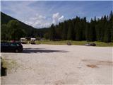
From Kranjska Gora over the border crossing Rateče we drive towards Trbiž / Tarvisio. Already after a few kilometers after the border crossing in the settlement Fusine / Fužine the road branches off to the left in the direction of the Belopeška lakes / Laghi di Fusine, which in a few minutes of moderate ascent brings us to a large parking lot at the Upper Mangart (Belopeško) lake. We park there.
Route description:
From the parking lot, we continue on the left side of the inn in the direction of the mountain hut Zacchi. The path at first runs along the forest road, which we leave after a few minutes, as the blazes direct us to the left onto a wide cart track (it is also possible to continue on the forest road; this variant is slightly longer). The cart track on which we walk turns into a footpath a little higher. The relatively wide and well-marked path, rocky in places, then brings us in a moderate ascent through the forest in about an hour of walking from the starting point to the mountain hut Zacchi.
Before or below the hut we find the sign "Ponza di Mezzo, Ponza Grande", which marks the beginning of the path towards the Poncas. The path first crosses the torrential riverbed, then ascends through steep dwarf pines, all the time slightly to the right, below the overhanging walls of the Poncas. Higher up it brings us to the first steel cables. Here the path turns a little to the left; a few times we ascend quite steeply along the steel cable. When we get very close to the walls below Visoka Ponca, the path leads us to the right, crossing a wide torrential gully. Then follows a shorter steep ascent to the right of the gully, which brings us to a path junction. To the right (sign "Ponza di Mezzo") branches off the path that leads to Visoka Ponca via a somewhat easier route (via normale) and to Srednja Ponca; we go to the left, onto the very demanding climbing path (ferrata).
We continue ascending to the right of the gully, partly over the steep slope of Srednja Ponca, partly across rocky ledges. When we cross the gully again, this time of course to the left, we stand at the entrance to the ferrata.
The most difficult spot is right at the beginning: the first few tens of elevation meters we climb up the vertical gully, after which follows an exposed traverse to the left. Immediately after the traverse the terrain flattens a little; we wind nicely through the passages, in places helped by a steel cable or temporary rope, and over one shorter section by a ladder.
In the summit section the ferrata flattens out completely; there are no more steel cables, and unfortunately mostly no blazes either. Cairns help us in places. Orientation in this part is otherwise not demanding if visibility is good. In a moderately steep ascent over gravelly terrain we soon reach the summit.

Photos:
 1
1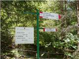 2
2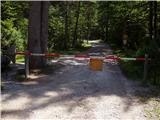 3
3 4
4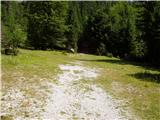 5
5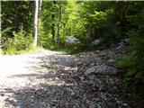 6
6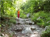 7
7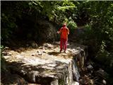 8
8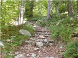 9
9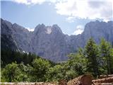 10
10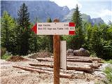 11
11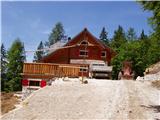 12
12 13
13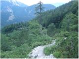 14
14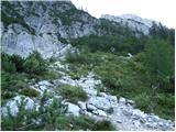 15
15 16
16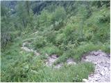 17
17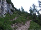 18
18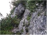 19
19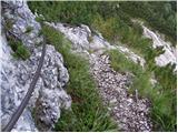 20
20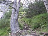 21
21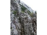 22
22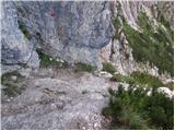 23
23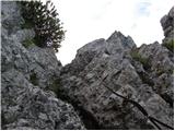 24
24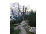 25
25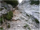 26
26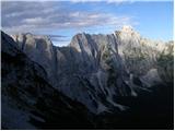 27
27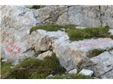 28
28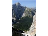 29
29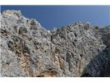 30
30 31
31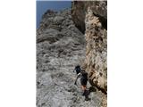 32
32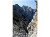 33
33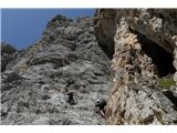 34
34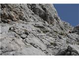 35
35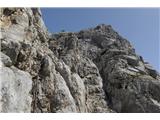 36
36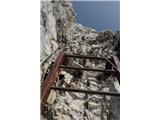 37
37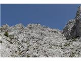 38
38 39
39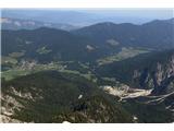 40
40 41
41
Discussion about the trip Belopeška jezera - Visoka Ponca (ferrata)
|
| trdi7721. 07. 2019 |
Hi!
I'm wondering if anyone has recently been to Visoka Ponca from Belopeška jezera? Is the path via ferrata normally passable? I'm also interested in the ferrata's difficulty. Is it similar to via Italiana ferrata below Mangart? Is ascending the ferrata to the top somehow difficult (due to scree)?
Best, Uroš
|
|
|
|
| Peter Pehani21. 07. 2019 |
Uroš, hi,
haven't been up recently, but 2 years ago it was ok (somewhere instead of proper cable just rope).
Regarding difficulty: if you look only at the steep climbing section, it's veeery short (maybe 100 vertical meters) and incomparably easier than the ferrata in Mangart, which runs up by bivouac Nogara. Overall, the tour to Ponca is much more alpine, with long and steep approach, and demanding descent on the "easier" but still very demanding path near the top (while access to Mangart ferrata is usually from the saddle down; once outclimbed, you're just 15 minutes from the car).
best peter
|
|
|
|
| maartin22. 07. 2022 09:35:42 |
Yesterday I completed this tour and think it will be useful to someone.
The path is interesting, beautiful, well protected. With a couple exceptions: 1) Before the upper (proper) ferrata section, cross a rocky part that is quite exposed and unprotected. Be very careful there and proceed. 2) Towards the summit no blazes but only cairns (stacked stones). Don't veer left around rocks where it looks trodden, follow cairns. (and upper comment on rope - yes, instead of one cable a slightly weathered rope is installed, but section is few meters and not dangerous)
Descent is another story - most choose loop via "normale". If adrenaline junkie or very experienced hiker, no issue. Down via Normale technically not too demanding, but two completely unprotected sections. One: left foot on grass patch with scree, right grab rock that can crumble anytime meaning certain death. Triglav path was child's play compared to this loop descent.
- Heard lots of rockfall ascending. Path extremely friable. Thus, via ferrata kit practically mandatory, though ferrata climbable without.
- Huge scree on ground. Both directions poorly trodden. Mid-summer, buddy and I met no one in eight hours.
|
|
|
|
| bogdan@bzq.si1. 10. 2023 14:30:26 |
Was today, all ok, it really says closed, but it goes, no problem!
They will be renewing the cables, lots of bolts and cables along the path, not yet installed!
|
|
|
|
| Stoick9. 10. 2023 09:50:20 |
bogdan@bzq.si, down the normal way?
Asking because maartin writes that the descent there was very demanding at two points.
|
|
|
|
| DVas7. 11. 2023 15:33:45 |
Tough descent, but with caution and slowly it goes.
|
|
|
|
| VanSims12. 11. 2023 19:23:42 |
What is meant here by Via normale? The path from Srednja Ponca to Zacchija is not really insanely difficult and dangerous. Yes, you have to be careful as everywhere and no path should be underestimated.
Or do you have to get to SP or the path junction below it first. That is quite adrenaline-pumping. Today I would descend back down the ferrata itself. Also, except in the very lower part, it shouldn't be too difficult if we've already come up that way.
|
|
|
|
| Sandis818. 06. 2024 14:03:26 |
Today we were from the parking lot at the upper Belopeško jezero, past Koča Zacchi, via ferrata to Velika Ponca. All OK, path and ferrata in good condition, on the path before entering the last part of the ferrata two short snow patches. We made “steps” in the snow, without winter gear and if careful it's OK. To cross approx. 4-5m. Recommend ascent and descent the same way.
|
|
|
|
| Njataa7. 07. 2024 07:59:55 |
We were also at Visoka Ponca yesterday. The path is well marked, the cables on the via ferrata are new. After the end of the via ferrata, the path is easy to follow since cairns have been placed. There is no more snowfield. However, you still need to be very careful because there is a lot of loose rock (both small and large) that you can easily trigger if not careful.
|
|
|
To post a comment you must log in:
If you do not yet have a username, you must first
register.