Bele Vode (Rebršak) - Smrekovec
Starting point: Bele Vode (Rebršak) (750 m)
| Latitude/Longitude: | 46,4134°N 14,9303°E |
| |
Walking time: 2 h 5 min
Difficulty: easy marked way
Elevation gain: 827 m
Elevation difference along the route: 827 m
Map: Kamniške in Savinjske Alpe 1:50.000
Recommended equipment (summer):
Recommended equipment (winter):
Views: 87.874
 | 3 people like this post |
Access to starting point:
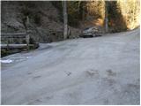
From the highway Ljubljana - Celje, we take the exit Mozirje and follow the road ahead in the direction of Mozirje and Logarska dolina. Immediately after the village Ljubija (which is located a little before Mozirje), the road to Bele Vode branches off to the right. The road then runs through the village Ljubija again and 500 m after the village brings us to a junction, where we continue straight on the road which runs along the stream (right: Šoštanj, Lepa Njiva and Bele Vode). We follow this road, which soon becomes macadam, straight at all junctions along the stream. When we get to the junction where the road to Brložnik branches off to the left over a bridge, we park on the parking lot by the road (the parking lot is 50 m ahead).
Route description:
From the parking lot, we cross a bridge and ascend along the road in the direction of Brložnik and Smrekovec. After a few minutes' walk on the road, we leave it, as the blazes direct us left onto a footpath, which over a small bridge crosses the stream. The path then ascends through the forest and somewhat higher crosses a pasture fence, after which the path turns left onto grassy slopes. After approximately half an hour of walking from the parking lot, we step onto the road at Spodnji Brložnik. Immediately after the information board, which stands by the road, we continue right on a cart track, which quickly brings us to the mentioned farm. A well-marked path behind the farm turns right and past the hunting observatory, chapel and trough with water soon brings us into a spruce forest. The path through the spruce forest ascends gently along a cart track, which after some time brings us to a forest road, where there is a junction.
We continue straight in the direction of Smrekovec (right Andrejev dom na Slemenu) on the path, which ascends somewhat more steeply. After a few minutes of further walking, we reach a large meadow, through which the path in a few minutes brings us to the Dom na Smrekovcu.
From the hut, we continue on the path in the direction of Smrekovec. The path first moderately ascends across a grassy slope, then goes into the forest, where it steeply ascends for a short time. The steepness quickly eases and the path brings us to a junction, where we continue slightly right in the direction of Smrekovec (left Komen). The path ahead leads us through increasingly sparse forest quite steeply upward. After a few minutes, we finally come out of the forest and the path flattens. There follows only a few minutes of easy walking along the panoramic summit ridge of Smrekovec to the stone pyramid, which we see on the top.

The trip can be extended to the following destinations: Krnes,
Komen
Photos:
 1
1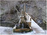 2
2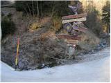 3
3 4
4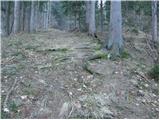 5
5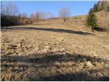 6
6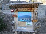 7
7 8
8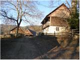 9
9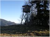 10
10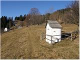 11
11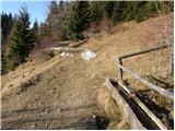 12
12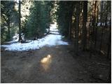 13
13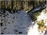 14
14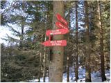 15
15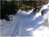 16
16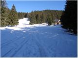 17
17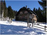 18
18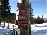 19
19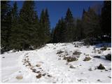 20
20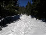 21
21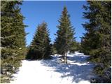 22
22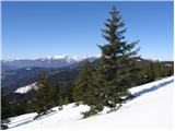 23
23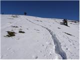 24
24 25
25
Discussion about the trip Bele Vode (Rebršak) - Smrekovec
|
| Tadej14. 02. 2008 |
Yesterday I climbed to Smrekovec via the path described above. Snow starts a bit above 1000m, but the path is well trodden so gaiters are not necessary. The path yesterday was not icy either. The weather was wonderful and almost windless.
|
|
|
|
| trilko19. 07. 2010 |
On Saturday I was on Smrekovec, really super trip, at this time of year there are tons of blueberries (and blueberry pickers).
I came from the direction of Šoštanj to Bele Vode, where I followed the red signs for Smrekovec. The path from there is long (4h), plus the initial part of the path (around Sv. Križ) is very overgrown (nettles) and part of the path has to be walked on the asphalt road (both up and down).
I recommend driving past Bele Vode to Rebršak (http://geopedia.si/?params=L1173_F57080_T105_vF_b4_x496535_y140859_s14), which is the starting point of the above-described path. But I know for next time 
|
|
|
|
| damijanp9. 02. 2011 |
I also recommend the path through Bele Vode. The road is in better condition than the one from Mozirje.
Some photos from Monday's trip are at:
Smrekovec
|
|
|
|
| čemaž26. 06. 2011 |
I was on this path today from Rebršak. Really nice path. Wild cherries are also ripening, and may the owner not mind me. And if the hut keepers are friendly, the trip is perfect.
|
|
|
|
| zcebe30. 06. 2011 |
Interested in path from Rebršak - how much of path or road is macadam? Planning trip for Saturday, please help
|
|
|
|
| geppo1. 07. 2011 |
If coming from Lokovica, there's about 500m of macadam in the forest in between.
If coming from Mozirje/Ljubija, then a few km of macadam (about 3km).
After parking at the parking lot (Reberšek), then some time on a forest road and then a nice path that gets you under the hut on Smrekovec in less than an hour.
|
|
|
|
| matdra14. 05. 2012 |
Is the hut keeper (Fiko) unfriendly to anyone else? Of all keepers, Fiko was the most "weird".
|
|
|
|
| geppo14. 05. 2012 |
"Fika" is like the dish "vampi po tržaško": either you hate them or love them....
according to rumors the keeper stays on.. did they look for a new one this year?
Lp
|
|
|
|
| Janiel7414. 05. 2012 |
But "Fika" even has his nick on the stamp. And even his sign on the path... I have a long tongue, so I asked him a bit surprised if that's him :). He looked at me strangely and said yes. For food I'd have to wait another hour...(and it was already after 10am)...
|
|
|
|
| matdra28. 05. 2012 |
This hut is like from the fairy tale Hansel and Gretel. Outside all nice and tidy, inside though a witch
|
|
|
|
| smatjaz9. 06. 2013 |
Today I was up there, in my opinion this Fika must be a legend and everyone should know exactly that he's not in a race and does his job precisely, even if it takes a little longer and that's right. We can do some things ourselves and wait a minute or two, right? Otherwise, fantastic trip to this little volcano and no complaints about the hut either (maybe I'm just modest) and to everyone planning to go up there, don't let yourself be discouraged and enjoy, because there are many reasons for that up there.lp Matjaž
|
|
|
|
| sova5517. 09. 2013 |
Was up there on Sunday and noticed that a lot has changed for the better in the hut. Everything is as it should be. Some would like hotels in the mountains though.
|
|
|
|
| šoni20. 06. 2014 |
DEFINITELY GO TO BELE VODE FROM ŠOŠTANJ (ASPHALT), UNLESS YOU CAN'T GET THERE BY TRACTOR, THEN ALSO FROM LJUBIJA. 
|
|
|
|
| šoni23. 06. 2014 |
WARNING!! this road is closed and if you go in the opposite direction (towards Ljubija) you have to turn back a couple of km, because there is no sign at the junction, June 2014
|
|
|
|
| radegunda31. 10. 2014 |
How far (from the Mozirje direction) can you then normally drive with a personal car (and park)? 
|
|
|
|
| radegunda15. 11. 2014 |
Today it was possible to drive by car to the point where the trail to the source of the Ljubija river turns left. Further on there was a road closure as they are renovating it. The macadam is completely new
|
|
|
|
| francf195. 02. 2018 |
Yesterday's trip to Smrekovec was wonderful. However, I definitely recommend (especially in winter) the route via Šoštanj, Bele Vode, Sv. križ, where the road is asphalted. Parking is right at the end of the asphalt near the mentioned unusual basin, second picture. On the hiker's recommendation, I drove another approx. 2 km uphill to the mentioned farm (from below the road was still completely passable). Google maps or navigation to help (Bele vode 43).
|
|
|
|
| Stamp19. 10. 2019 |
We plan to do a circular route tomorrow. Asking: is the descent from Smrekovec right over Rom and down south passable (probably not marked)?
|
|
|
|
| sh21. 05. 2021 19:11:47 |
Please provide information if it's possible to reach this starting point or parking lot with a larger bus.
|
|
|
|
| drdivx21. 05. 2021 21:08:36 |
You can reach Rebršak also with a larger bus. The problem is with the parking lot, as it might be occupied, the parking 100 meters back at Luka. In that case, there's parking available at the Honec saddle, 500 meters back towards Bele Vode.
|
|
|
|
| sh21. 05. 2021 21:30:22 |
Thanks for the information. If necessary, we can manage the extra meters too.
|
|
|
|
| Tomaž0029. 04. 2022 15:44:26 |
Today we walked this path, it's well marked, the weather was great, service in the hut excellent
|
|
|
|
| Borut120. 04. 2024 20:54:45 |
Is it still true that the road to the starting point is better (more asphalt) from the direction of Šoštanj?
|
|
|
|
| geppo21. 04. 2024 08:35:07 |
The Mozirje - Ljubija road was in very poor condition after the floods. It is under reconstruction and usually occupied by construction machinery - walked on foot in February 2024. Better to go from Šoštanj.
lp
|
|
|
|
| natasacraine21. 04. 2024 12:03:46 |
I came through nicely in March, even though they were renovating it. But it's true that I only noticed the signs on the way back that the road is closed and I should have made a detour.
|
|
|
|
| gregorjaunik17. 06. 2024 19:46:06 |
Hello.
I'm wondering if they have a dog at the Brložnik farm, because we have our own dog on a leash, but on some farms dogs are loose, and I don't want any trouble. Thanks for the information and safe steps.
|
|
|
|
| andi218. 06. 2024 08:48:27 |
The Spodnji Brložnik farm has been abandoned for quite some time, unless someone has turned it into a weekend cottage now. As written above, many even drive up to it, park there, and continue. Good luck!
|
|
|
|
| bojanslo14. 06. 2025 20:39:16 |
Hello!
Today we visited the hut on Smrekovec and then continued climbing to the "Piramide nad Smrekovcem", which is at 1577 m above sea level.
We started at the parking area under the house "BELE VODE 43", where the path is an asphalted road all the way, coming from the direction of "Šoštanj". Park nicely there and head uphill past the house Bele vode 43.... We, not being really "fast", took exactly one hour of walking to the hut on Smrekovcu.... Then another 30 minutes to "Piramide nad Smrekovcem" which is about 200 m of elevation gain from the hut on Smrekovcu to the pyramid.
From the parking lot you start at 969 m above sea level and to Piramide nad Smrekovcem it's exactly 4 km of walking and 608 m of ascent... Really pleasant path.
|
|
|
To post a comment you must log in:
If you do not yet have a username, you must first
register.