Planina Blato - Planina v Lazu
Starting point: Planina Blato (1147 m)
| Latitude/Longitude: | 46,3112°N 13,8501°E |
| |
Walking time: 1 h 40 min
Difficulty: easy marked way
Elevation gain: 413 m
Elevation difference along the route: 500 m
Map: Triglav 1:25.000
Recommended equipment (summer):
Recommended equipment (winter): ice axe, crampons
Views: 30.506
 | 4 people like this post |
Access to starting point:
From the Ljubljana-Jesenice motorway, take the Lesce exit and follow the road towards Bled and further towards Bohinjska Bistrica. Continue driving towards Lake Bohinj (Ribčev laz), where you reach a junction and continue right towards Stara Fužina. In Stara Fužina, at the junction by the chapel, turn sharply left onto the ascending road towards Planina Blato, Planina Vogar and Voje valley. The road then takes you to the toll and parking fee point, but follow it further to the next junction, where you continue left (right Voje). Follow the road to the next junction (driving takes quite some time), where you turn sharply right towards Planina Blato (straight Planina Vogar). Then follow this road to the parking lot above Planina Blato.
Route description:
From the marked parking lot in front of Planina Blato, return slightly back and head to a wide and initially steep cart track, alongside which are signs for Planina pri Jezeru. After about ten minutes of ascent, arrive at a marked junction, from where continue slightly right towards Planina v Lazu (left Koča na Planini pri Jezeru).
The path also continues through the forest, but gently ascends to a junction a few minutes away, where a steep path to Planina pri Jezeru branches left.
Here the path to Planina v Lazu turns right and gradually becomes steeper again, ascending transversely through the forest for some time, higher up entering the forested valley Pri deklici. The path continues northwestwards, still ascending through the spruce forest. When the forest flattens higher up, arrive at an unmarked junction, where an unmarked shortcut to Ogradi and Planina Krstenica branches right, we follow the gentle path continuation to the marked junction near Planina v Lazu.
Here a marked path to Planina Krstenica and path to Ogradi branches sharply right, we continue straight towards Planina v Lazu and in a few minutes of moderate descent arrive at the mentioned pasture, where a large number of shepherds' huts stand, and in the middle of the pasture also a dairy.
Starting point - Pri deklici 1:00, Pri deklici - junction before Planina v Lazu 0:35, junction before Planina v Lazu - Planina v Lazu 0:05.

Along the route: Pri deklici (1463m), Razpotje pred Planino v Lazu (1602m)
The trip can be extended to the following destinations: Planina Blato (5 h 30 min),
Koča na Planini pri Jezeru (1 h),
Vrh Hribaric (3 h 30 min),
Debeli vrh (2 h 30 min),
Vršaki (Vrh za Koritami) (4 h 10 min),
Vršaki (Srednji vrh) (3 h 50 min),
Vršaki (South peak) (4 h 20 min),
Vršaki (Vzhodni vrh) (3 h 30 min),
Teme (Hribarice) (4 h 35 min),
Poprovec (4 h 50 min),
Kanjavec (4 h 15 min),
Kanjavec (West peak) (4 h 15 min)
Photos:
 1
1 2
2 3
3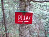 4
4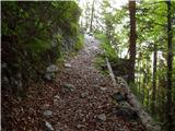 5
5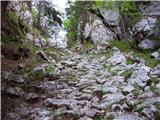 6
6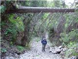 7
7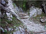 8
8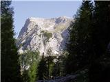 9
9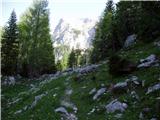 10
10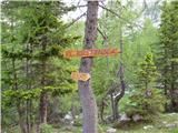 11
11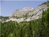 12
12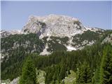 13
13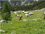 14
14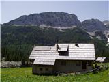 15
15
Discussion about the trip Planina Blato - Planina v Lazu
|
| uzbic26. 08. 2011 |
Can someone describe the path from Krstenica to Planina v Lazu, please? On Sunday we would set off with children on a circular tour Planina Blato-Krstenica-Planina v Lazu-Planina Blato.
Is it suitable also for smaller ones?
|
|
|
|
| mukica27. 08. 2011 |
This path is very nice, maybe at the beginning after the cableway (at least last year it was all torn up) nicely laid out in switchbacks almost to Krstenica. From there to Pl. Laz it's almost flat and nothing strenuous... suitable for all generations
|
|
|
|
| mukica27. 08. 2011 |
This path is very nice, maybe at the beginning after the cableway (at least last year it was all torn up) nicely laid out in switchbacks almost to Krstenica. From there to Pl. Laz it's almost flat and nothing strenuous... suitable for all generations
|
|
|
|
| uzbic30. 08. 2011 |
We were there, and it really is nice. Thanks for the tips.
|
|
|
|
| Enka2. 08. 2018 |
Is this trail passable, has anyone walked it in the last days? Last time I just passed by, and there was already a fallen tree in the first meters.
|
|
|
|
| Enka3. 08. 2018 |
Does really no one know anything?
|
|
|
|
| djimuzl3. 08. 2018 |
Sometimes you just need to search a bit.. e.g. on the PZS path status..
Planina Blato - Planina v Lazu
Maintainer: PLANINSKO DRUŠTVO LPP
Area: Gorenjska, Julijci
Section: G2346_1, Easy path, D = 443 m
Pungrat Z - Pungrat V
8.5.2018
Due to fallen trees the path is impassable and CLOSED until further notice
|
|
|
|
| Enka3. 08. 2018 |
djimuzl, you know you are right?!  Thanks! Thanks!
|
|
|
|
| pojoča travica5. 08. 2018 |
The path from Planina Blato to Planina v Lazu is officially closed, but unofficially they have cleared it enough that you can reach the pasture. However, you still need to climb over some fallen tree somewhere.
|
|
|
|
| a7a7a7a109. 05. 2020 |
I'm wondering if the path is nice, namely last year when we went on it with a stroller it was littered with trees . .
DOES ANYONE KNOW?
|
|
|
|
| saqo6. 08. 2020 |
Is the path passable now?
|
|
|
|
| mornar19. 07. 2021 11:03:07 |
I'm curious about the path from Planina Blato to Planina Laz. Is the path normally passable for slightly older people? Thank you and best regards.
|
|
|
To post a comment you must log in:
If you do not yet have a username, you must first
register.