|
| dm723. 12. 2012 20:44:13 |
Today's nice day, I used it for a short tour to White Brook Valley. Car parked at the bridge a bit higher, where Rajbelj Lake ends, and go on trail no. 625, which starts on the other side of the road. Trail winds along the stream all the way, cross it twice and finally reach the fairy-tale Brunner hut, which lies at 1432 m. The hut is extremely nicely arranged and placed in a nice location. There I stop a bit and then continue on trail 625, which goes past Gorizia bivouac (1950 m) that should be my goal today. Didn't quite reach the bivouac, as it was very misty in the gully below it, wind blew quite some snow into it. But I was almost at bivouac height, just that I was under Mala Lojtrica wall, because under the wall along the ridge it was blown clean. On top of all I had my dog with me, who was already quite tired, so no sense trudging to bivouac and we turned there. Views from here are truly magnificent plus everything dusted with snow. Yeah really beautiful this White Brook Valley. Back the same way.
 1 1 2 2 3 3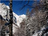 4 4 5 5 6 6 7 7 8 8 9 9 10 10 11 11 12 12 13 13 14 14 15 15 16 16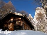 17 17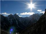 18 18 19 19 20 20
| (+8) |  | |
|
|
|
|
| SPIDER3. 12. 2012 21:45:44 |
White Brook Valley never disappoints you . Our photo of R. špic is the best . Our photo of R. špic is the best
| (+1) | | |
|
|
|
|
| sabina.79. 08. 2013 14:28:39 |
On Saturday early in the morning we set off with heavy backpacks along White Brook Valley to Bivouac Gorizia (1,950 m), around which there were some curious wild goats with kids. Here we rested and settled in, as we stayed up there until Monday morning. We watched four Gorizia alpinists who climbed the north ridge of High White Peak. When the sun wasn't scorching so much anymore, we headed up the steep scree slope towards the Alta di Rio Bianco saddle (2150 m). At the saddle we turned right, as the Centenary Path with fixed cables starts there, along which we ascend quite steeply. Then we have to descend vertically into a narrow notch, then climb again up a vertical ladder. Then the path is easier, but with very nice views. Interesting when in the last part it turns into a tunnel, with bends and descents on ladders, so a headlamp is mandatory. We used our phones. When we emerged from the dark, we soon reached the Krnica saddle and descended the scree to Bivouac Gorizia. Beautiful, solitary but not lonely experience.
 1 1 2 2 3 3 4 4 5 5 6 6 7 7 8 8 9 9 10 10 11 11 12 12 13 13 14 14 15 15
| (+6) | | |
|
|
|
|
| Majdag7. 08. 2017 17:41:10 |
| (+5) | | |
|
|
|
|
| dprapr7. 08. 2017 20:10:25 |
On Friday it also had two visitors.
Nice up there, really. Views are magnificent.
| (+1) | | |
|
|
|
|
| lijaneja7. 08. 2017 21:29:23 |
Most often Visoka Bela Špica poses.
| (+1) | | |
|
|
|
|
| dprapr14. 06. 2019 14:29:21 |
Nice pics.
How they fixed that poor guy.
Landslide has been there for years. Maybe they check it every year before season, how it is, before opening the path. Not most pleasant to cross under it, because one day it will all come down.
|
|
|
|
| Tadej14. 06. 2019 16:21:28 |
Thanks.
Somehow I kept thinking the closed path is on section from Krnica saddle to Corsi hut, so I left ice axe in car, on return with Brane we noticed the landslide and concluded King's path closed.
Original plan was circular tour past Corsi hut.
 1 1
| (+1) | | |
|
|
|
|
| andraja14. 06. 2019 16:33:31 |
So, is the King's path closed again?
|
|
|
|
| Tadej14. 06. 2019 16:38:24 |
Well, now I read again and don't know, maybe it means only the mountain hut is closed.
|
|
|
|
| mirank14. 06. 2019 16:52:48 |
Yes, Corsi hut is closed, Bruner hut available by arrangement with society from Trbiž. That's what the sign says, some even in our language....
|
|
|
|
| hitrakotpolza28. 06. 2019 10:34:52 |
Yesterday we did circular tour White Water - over Krniška Škrbina to Corsi past Viška Planina to start.
From Gorizia bivouac to saddle snow on trail only in lower part and no problem.
On other side of saddle to Corsi some more snow, but also no problem there. Upper part dry.
Trail from Gorizia bivouac to Krniška Škrbina somewhat difficult (in steep part), as trail quite bad condition.
Safe stepping.
| (+1) | | |
|
|
|
|
| 2061alessio28. 06. 2019 11:57:33 |
The Saxon king's path is open again for a couple of years already, we repaired the landslide, now safe path with gear, Corsi hut will be closed for I think a couple of years because they plan (pd TRIESTE) to completely renovate it.
| (+7) | | |
|
|
|
|
| hitrakotpolza28. 06. 2019 13:20:57 |
Thanks 2061alessio for the info. We weren't sure about the path condition, so we decided for another path from Corsi.
| (+1) | | |
|
|
|
|
| julya30. 06. 2019 22:05:12 |
So Corsi hut is closed this year??
|
|
|
|
| velkavrh2. 07. 2019 05:33:15 |
Yes until further notice, because they will renovate it. Water easily gotten above hut left - about hundred meters higher at spring (intake).
|
|
|
You must log in to post a comment:
If you do not yet have a username, you must first
register.