| IgorZlodej10. 06. 2010 19:32:50 |
The mountain has been scouted for several years already. After a few years of collecting data from experts, observations from nearby mountains, and map reviews, last year came the news that the Stritar guys had climbed the mountain. Once, the army occupied it, they had radars up there, invisible battles raged between NATO and the Eastern bloc, the area was closed off, and the once-built paths lay abandoned for long years. A few years ago the army left the mountain, last year they even removed the supply cableway, and today I drive to Lužnica (Bagni di Lusnizza). The actual starting point is in Sveta Katarina, but since there's been no bridge there for years, the only way to cross without wading Beli potok and Bela is the old railway bridge in Lužnica. So I go over that bridge, where there's now a bike path, and walk about 15-20 minutes along the right bank of Bela upstream, then turn left onto the broad forested ridge, clearly visible from both Kanalska roads. Soon I find a trail marked here and there with old red dots and lines. The trail can be easily followed without special difficulties to Monte Pin (1506) and beyond. You rarely walk on such soft ground, really enjoyable, mostly soft grass and leaves in the forest. A bit higher the path turns to rockier terrain, there are even some very old forged pitons and some wire, then forest again, then I reach a clearing where there was a fire years ago. I ascend over these slopes under M. Ghisniz, a barely visible trail turns left under the cliffs of the aforementioned mountain. I traverse somewhat crumbly scree slopes always leftward, with some gullies in between where you have to be extra careful, as parts of the old trail are almost washed away in places. After a long traverse I reach the ridge, cross a notch, descend a few meters to the NE slope, then up a gully with some pitons and wire again to the ridge, and along it through bushes to the upper station of the former cableway. The structures on the summit plateau are truly infamous, from the cableway there's a long covered tunnel to the other objects, behind one building lies a huge radar dish, nearby a large concreted helipad that any alpine hut would envy. In short, the sight of the objects on the mountain shakes you, and the inevitable question is: Why? While surveying these objects I notice a rise to the west that seems even higher than the highest point where the abandoned military structures stand. There's even a cross on top. Since this could actually be the summit or at least the west summit of Šinavc, I of course head right to the cross. The path through dense bushes is quite hard to follow. Right at the cross I decide not to return the ascent route, but continue to Mokrine. I already knew the path from the top by description, and from planina Biffil I'd walked it before. I call a buddy and arrange pickup, then descend to the NW side of the mountain. Red dots safely guide me downhill (thanks Alessio). Below I fill up with water at a gully, cross it, and on the other side slightly ascend through forest, soon at planina Biffil, then a short ascent to an unnamed saddle and on along a nice panoramic path and later a real forest road all to planina Javornik where I meet my driver, who quickly did a short tour to Krnica and descended to planina Corona. Then another good 10 minutes to Mokrine pass, where sadly all taverns are closed, so had to go a few hundred meters to the Austrian side where they pour beer too, don't ask if we drank it. From Lužnica over Šinavc to Mokrine 7.30 h pure walking. Recommended for experienced who master pathless terrain flawlessly and have a sense of orientation.
 1 1 2 2 3 3 4 4 5 5 6 6 7 7 8 8 9 9 10 10 11 11 12 12 13 13 14 14 15 15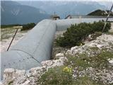 16 16 17 17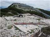 18 18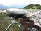 19 19 20 20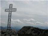 21 21 22 22 23 23 24 24 25 25 26 26") 27 27 28 28
| (+1) |  | |
|
|