Hiking-trail.net
hiking-trail.net
Login
Login
Username:
Password:
Login
Not registered yet? Registration.
Forgot password?
      
List of forums / Slovenia / Carnic Alps / Monte San Simeone

Monte San Simeone

Print
dm7223. 03. 2012 19:54:36
Today we went to the pre-Carnic mountain range, specifically to Monte San Simeone. The mountain or hill (1505m) doesn't look like much at first glance, but it's more interesting due to its elevation gain from Pioverna where we started, an enviable 1262 vertical meters. The path starts very steeply climbing and holds up to about 1200m height after which it flattens a bit (1km) then another approx 250 m of ascent to the top. At the top there's quite a nice view around but today due to mists unfortunately we didn't have it, but we had luck and saw white-headed eagles which nest in this range. On the way back we looked at the little church of Saint Simeon and descended via another path to the village Bordano, where we also looked at the butterfly house (casa delle farfalle) worth seeing then another approx 3 km along the main road to Pioverna where we left the car. Worth seeing is also the ancient little town Venzone which is on the other side.
Monte San Simeone 1
Monte San Simeone 2
Monte San Simeone 3
Monte San Simeone Monte Amariana4
Monte San Simeone Bearded vulture5
Monte San Simeone Chapel of Saint Simeon6
Monte San Simeone San Simeone plateau.7
Monte San Simeone Trobentice8
Monte San Simeone Beautifully decorated facade in Bordan9
Monte San Simeone Butterfly10
Monte San Simeone 11
Monte San Simeone Beautiful colors12
Monte San Simeone 13
Monte San Simeone Parrots can also be found nearby14
Monte San Simeone And also flowers15
Monte San Simeone 16
Monte San Simeone Venzone17
Monte San Simeone Entrance to the town of Venzone18
(+7)like
tulipan24. 02. 2013 09:48:08


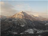
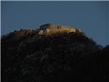
Yesterday was as the forecasters predicted, namely clearing around San Simeone at 10am. Everything held true, only the path choice was wrong. On path 838 to Monte San Simeone via Plan dai Purcei saddle there were such high drifts that I turned back just below the summit. Repetition follows, circular path also with visit to Monte Festa

https://plus.google.com/photos/113334581701584163856/albums/5848448980960679937
1
(+3)like
tulipan22. 03. 2013 17:03:10
Second attempt was only partly successful, as fatigue during descent from Monti Festa made me give up, though it was only 15 min away.
Proverb says third time's the charm.
Today was a sunny, warm day.
From start via road and some shortcuts good 2 hrs.

https://plus.google.com/photos/113334581701584163856/albums/5851048768114344145

https://plus.google.com/photos/113334581701584163856/albums/5858191924757863649
1
(+2)like
bagi19. 01. 2018 09:19:39
Started from Interneppo saddle. From Ljubljana (Rudnik) 190km whether via Primorska or Gorenjska . At start chose loop via Monte Festa to San Simeone and descent by famous adrenaline road to pasture. Adrenaline for drivers coming up in summer with iron horses, hikers have many well-marked and maintained shortcuts.

Access on path 838 to interesting fortress mountain - Monte Festa last weekend (14 Jan) completely dry, unofficial upper pass to San Simeone needs winter gear due to iced snow. At least microspikes desired also on San Simeone slopes.

At its summit total surprise. Just as we reached the top white-headed eagles with wings over two meters flew past us. First two, then two more, five, ten, twenty and more . In light breeze elegantly gaining height and spoiling us with close views. Unrepeatable

We started a little below the official parking lot and followed the *Poti metuljev*1
On path 838 we walk the first few kilometers on a scenic road closed to traffic2
Tod once led a path towards Monte Festa, or rather the former pasture below it3
The pasture was replaced by a huge military facility from WW14
The military complex was the support for the mountain fortress - Monte Festa5
Towards the summit. The entire summit is turned into a fortress of incredible dimensions6
The fortress and hinterland are connected by numerous horizontal and vertical underground passages7
The fortress has several levels. This one is a shade lower than the highest8
From here they had complete control over the valley of Bela9
On one of the three fortified positions for 194 G caliber guns10
They also had control in this direction11
We12
Upper fortress13
The underground spaces are very well preserved for their age14
Well ... not quite everywhere anymore :)15
Crossing16
And again at the rear structures. The *unmarked* upper path to Monte Simeone continues straight without descending the road17
The upper passage to San Simeone was once marked, now follow the black tracks18
The snow is icy, the slope not too steep. In case of a fall it would go far down in many places19
Towards San Simeone20
When you spot the transmitters, you are almost at the top21
Group22
This peak is also an excellent viewpoint23
One of the nicer logbook boxes .....24
 .... guarded by an even cuter ladybug25
Unfortunately I didn't have the right lens. More and more were coming, they glided at the height of our heads and elegantly rose upwards26
At least twenty I counted above us, impossible to show all. And new ones kept appearing27
We descended towards Bordan28
We had a nice day from the morning already29
Mushrooms are already growing here too :)30
snapshot31
Ridge of Monte Brocheta32
Road to the alpine pasture. 11 km long, very narrow, with countless bends. Shortcuts for hikers33
Map of the hiked path34
(+6)like
skalaš7023. 10. 2018 20:35:11
Bravo "voluharji", great tour, pics and of course nice young girls fit right in .... I admit, I always enjoy looking at your interesting posts!
Thanks and safe steps ahead!!!
(+2)like
voluhar25. 10. 2018 14:17:31

Thanks nasmeh
(+1)like
turbo7. 12. 2023 11:08:28
Monday, 4/12/2023

Third time, first time solo. Parking above Sella di Interneppo pass of course free, there also panoramic board and table with benches. Along the road to the hiking trail junction, then mostly shortcuts through the forest, marked, to the plateau or altipiano. On the road where I had to go, icy, in the forest trodden, crampons and gaiters unnecessary, too little of such and other surfaces. Last slope through forest to summit a bit more snowy, say to ankles, but easy without gear. Views gorgeous, makes your eyes misty, weather friendly, maybe a degree too cold though no severe frost. Adriatic Sea was sparkling and shimmering, whether it was also roaring I dare not say, was too far. During descent detour to the little church, bit of sitting in it always does good, then just down. During descent a bit fewer shortcuts to hit one of the tunnels, beautiful ice candles and icicles in it, and the trip was over. It was nice, with the "fatty" as it looks from the valley, surely we haven't said the last (bicycle) nasmeh

https://tubojan.blogspot.com/2023/12/san-simeone.html
1
2
3
4
5
6
7
8
9
10
11
12
13
14
15
16
17
18
19
20
21
22
23
24
25
26
27
28
29
30
31
32
33
34
35
36
37
38
39
40
41
42
43
44
45
46
47
48
49
50
51
52
53
54
55
56
57
58
59
60
61
62
63
(+5)like
palček plezalček25. 12. 2023 10:41:14
Via delle Lavare - M. San Simeone - ridge to the west - M. Festa - ridge to the west over Cuel di Mena

Via delle Lavare is poorly marked, marks are old, so keeping an eye on them doesn't miss; it happened to me several times that I went a bit on my own nasmeh .

The last part of the path to San Simeone is well marked (above Casera S. Simeone).

From the top pathless along the ridge and descent to the scree, where unofficial marks start that come from Plan dai Purcei. Following them to the west (there are so many that if you don't see dots, lines or arrows within less than 5 meters, you can wonder if you're lost. velik nasmeh ).

On the ascent to M. Festa you're most likely to meet some living soul.

From it along the ridge to the west there's no path, even though it's drawn on Tabacco map 013.

The tour is mostly pathless and despite low elevation complex. Total: 1700 elevation gain and 18.20 km.

More with the pictures.
Above Pioverna - there are several paths, so it's good to pay attention to the markers1
There are dots and lines, but Knafelc marks are also present2
Illuminated Cima di Campo and behind it the continuation of the Muscev ridge3
Stone men are helpful in places, elsewhere they are a bit obtrusive4
A little further straight and even to the left, then in the direction of the sunlit summit5
Crazy mountains :)6
Kraman Ridge from Deneala to the left7
snapshot8
The morning sun soon yielded to the clouds9
From log to log10
Oh, these views11
Towards Casera San Simeone12
I avoided the pasture; I dismissed it and went straight up here to the white road13
Along it to the junction for the summit14
towards the summit15
Holes16
Who on the tour doesn't go higher17
Beli Karnjici behind Tolmeč and Amarina to the right18
Along the S. Simeone ridge towards the west19
The next peak low among the branches20
Before this spur left, as right doesn't go, straight even less21
Descent to the marker visible on the tree at the saddle and there to the right22
There are unfinished markers in abundance - I counted 8 of them on the picture23
Here there are 7 - you just walk without thinking, until...24
...you reach the fairly built-up M. Festa25
A peek back at San Simeone26
Fortress of M. Festa27
Lago di Cavazzo28
The next section is the descending ridge (to the snow patch).29
Battle positions on M. Festi.30
From them across like this downhill to the saddle, where the pathlet should be caught.31
At the saddle to the left, but no sign of the pathlet.32
It is quite steep here - the path should be a bit lower, but I can't see it.33
I choose this spot for ascent to the ridge and the path should also go here - placed a cairn.34
About the path's existence one can argue; you scramble honestly and I have barely started the crossing.35
A little higher36
Over the boulders to the ridge...37
...which looks like this...38
...and like this...39
...as well as like this... 40
...and even like this, as it looks behind the pine.41
Peek back42
To the north right below is Amaro.43
What is that grassy circle further along the ridge?44
Already quite low the first sign of human presence.45
The circle turned out to be a battle position.46
Does not go right here (descent direction), so I continue straight ahead...47
...until I 'fall' onto the pathlet amidst the brambles...48
...and along it in a minute I reach the return path, which is a cycle trail.49
Why it is not suitable to descend along the gas pipeline trace.50
The return is long, but not uninteresting51
Even white-headed hawks fly over me52
River Tilment/Tagliamento53
Past the avenue of palms to the starting point54
55
(+8)like
zokipoki25. 12. 2023 12:56:48
Wonderful tour!
(+1)like
ljubitelj gora14. 12. 2025 22:19:26
Some of today's pictures
Lopič, Javor1
2
Karmen3
4
Amariana5
Coglians6
7
Po Plain8
9
(+2)like
You must log in to post a comment:
Username:
Password:
Login
If you do not yet have a username, you must first register.
         
Copyright © 2026 Hiking-trail.net, Terms of use, Privacy and cookies