|
| jaz1. 11. 2008 23:06:39 |
On Saturday I relived memories a bit on the ascent to it when I watched it from the ridges on the opposite side. Lp!
|
|
|
|
| IgorZlodej29. 06. 2012 19:51:53 |
Almost 5 years ago in early October we couldn't reach the summit due to snow. Today we started at Tolazzi hut and in the morning cold reached just below Lambertenghi-Romanin hut in a good hour. There we turned left over scree under the entry gully. A short rest follows, then scrambling, through short gully nothing special, then steep grass and scant path, followed by traverse right and up, then a somewhat harder spot in the wide gully on smooth slabs (II.), continuation easier again, then traverse along and under narrow exposed ridge (presumably the hardest spot), then up again, a bit around. When we reach the few meters long fixed cable (only belay in the route, which is not necessarily needed) we already know the summit is not far. Follows easy climbing on solid rock all the way to the top. It was nice to step onto the summit. Followed a rest and viewing the known mountains that are already quite familiar to us. Then descent, which requires all foresight, we didn't use ropes, although there is an anchor at one spot. Below we turned to Piero at Lambertenghi hut, whom we know since last year, short chat and then visit to the Austrian hut, which they are renovating, yet they friendly serve us very tasty strudel with cream and of course Gässer, which we fairly earned. Then descent to Tolazzi. The route is marked with still faded dots and quite followable.
 1 1 2 2 3 3 4 4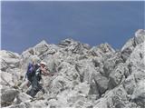 5 5 6 6 7 7 8 8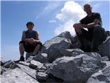 9 9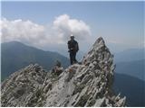 10 10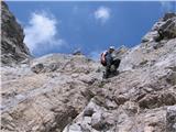 11 11 12 12 13 13 14 14
| (+8) |  | |
|
|
|
|
| IgorZlodej27. 08. 2014 13:59:35 |
Red dots are fully official Italian markings for ascent routes or paths not secured, same marking on their maps usually with climber drawn  . .
| (+3) | | |
|
|
|
You must log in to post a comment:
If you do not yet have a username, you must first
register.