| IgorZlodej2. 09. 2010 20:34:52 |
After Tuesday's visit to the Carnic Alps, when I watched the Coglians group, I quickly realized that there was significantly less snow there than in the Julian Alps. So today my buddy and I went on the tour completely carefree. The early morning was so nice that our wishes were almost too big, but in the end we drove to Plöckenpass, which was still deserted when we arrived. We stepped into the cold morning on path 146 and soon reached the sun, which appeared from behind Pal Piccolo. On the flat area under the mighty Collina, cows were grazing peacefully, while we went past the ruins of a former military object along the old mule track to Cresta Verde. Just below the entry into the eastern slopes of Collina, we stopped for a moment, then continued; at first it's mostly grade I climbing, the second part is normal walking on a marked pathless terrain. With nice views of the queen of the Hohe Tauern and many of her neighbors, we reached the summit, had a snack, then descended a few meters and headed from the ruins along the old military path, which is marked with ordinary Italian markers, which I hope won't mislead anyone, namely if anything, there should be red dots there. The path is not marked on the map, nor is it secured, although it used to be, as evidenced by the bolts with rings, but that's from very old military times. In places it's quite exposed, the final gully that leads to the top is somewhat difficult and exposed in the lower part. There we ran into three Italians and quickly realized we had a mutual acquaintance Benita from Reana del Rojale, who unfortunately passed away 4 years ago. Because of the fog that persisted on the southern slopes, there were no special views, so we returned below Collina and descended on the path that is secured with a cable in the lower part and joins lower down the path coming from the Marinelli hut. A short descent more and the nice loop is closed, followed by descent back to Plöckenpass, then we drove to the frequently visited Valentin Alm, where over beer and cream strudel we admired the wall above which we stood just a few hours ago.
 1 1 2 2 3 3 4 4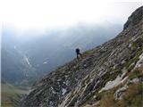 5 5 6 6 7 7 8 8 9 9 10 10 11 11 12 12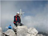 13 13 14 14 15 15 16 16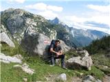 17 17 18 18
| (+1) |  | |
|
|