MONTE PATERNO-PATERNKOFEL
|
| JORDAN9. 08. 2010 09:38:45 |
07.08. we visited the area of the Three Peaks and some climbed Monte Paterno from Locatelli hut via ferrata De Luca-Innerkofler, descent via ferrata De Luca. Protections are in excellent condition. Helmet and via ferrata kit mandatory due to large crowds of inexperienced hikers on ferratas and consequent rockfall.
I recommend ascent from Locatelli hut through the galleries, descent via the other two paths, as it's a circular route and crowding occurs due to descending the approach path because of large number of ascending hikers.
|
|
|
|
| IgorZlodej15. 09. 2011 07:36:48 |
After climbing Torre Toblin, after a short stop at Locatelli hut, we head to the summit of Monte Paterno. The first part of the path follows a faint ridge, then we enter a gallery consisting of some small tunnels at the start, followed by a long tunnel where a headlamp is necessary, helmet highly recommended. When the tunnel ends, the ferrata continues, not particularly difficult, but self-belaying recommended as rocks are more polished than on our Triglav. At the notch reached via north face there's a short more exposed section with cables, then free climb some easy spots to the top. Path marked only with cairns. Views from top are excellent, no need to write about them. The story of the two mountain guides tragedy from WWI is known, no need to repeat. Summit descent part via ascent path, then just below the notch turn right, descend SE gully and right to path on ledges, at second notch cross to west side, path continues on ledges, some exposed spots secured with cable. At end short gallery almost on knees. Then short descent to saddle usually full of visitors, plenty this time too. At Lavaredo hut of course beer and nice views of Tre Cime. Return via path to Auronzo hut. Note for those going: toll is 22 €.
 1 1 2 2 3 3 4 4 5 5 6 6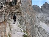 7 7 8 8 9 9 10 10 11 11 12 12 13 13
|
|
|
|
| enigma16. 09. 2011 23:55:05 |
Nice photos, I also walked the nearby and distant surroundings. Just adding about prices, toll is indeed 22 euros, but if you overnight in the hut you'll pay 5 euros extra per following day, double room at Auronzo hut for one day is 60 euros (30 per person), for half-board extra 22 euros. If you want to shower at hut another 5 euros. Yeah, it's not really cheap, sleeping is very cheap compared to Cortina d'Ampezzo where rooms are from 90 (one) to 140 (three stars) euros. lp
|
|
|
|
| Janezs17. 09. 2020 09:52:26 |
We start the path at Auronzo shelter, packed full with cars. Even on the walking road almost no space. Higher through tunnel and over scree fewer people. Upper part on scree requires more careful walking. We return same way. We leave tourist area and drive west to Cortina d'Ampezzo.
|
|
|
|
| bagi13. 09. 2025 11:16:22 |
Every now and then we visit peaks where we've been before. This time it was Monte Paterno with view to famous Cime. If possible we choose different starting point to not repeat too much. This time first from Val Fiscalina valley and managed nice loop. In my opinion best valley approach for this area.
Val Fiscalina has three parking lots. Top two paid, the one in Moos free. Many use frequent buses to save some road walking km. From end station footpath to renovated and enlarged Rif. Fondovalle hut. There turned right to path 102 towards Rif. Locatelli hut, on one of nicest locations in all Dolomites. Accordingly huge tourism, but prices still lower than ours. How do they manage  ? ?
From here could go promenade towards next Rif. Lavaredo hut, but chose to visit Monte Paterno via Innerkofler ferrata. This is extremely interesting WWI remnant, like much around here. Summit visit slow as crowds, but on two harder parts two-way traffic arranged. Descended secured Passaporto path and marveled at incredible crowds below. It's autumn here, and midweek arrival. Unbelievable  . .
After hut visit continued towards Lago di Cengia lake and Rif. Pian di Cengia hut via signs 104. This part very scenic, path real treat. Wide and graded, can switch on autopilot and admire nature. To lower Rif. Zsigmondyhütte more mountaineering path 101, further to Val Fiscalina valley 105. There closed loop and headed to start. Summary only one … highly recommend  . More in photo-story … . More in photo-story …
Start coordinates: 46.6735594N, 12.3604142E
 1 1 2 2 3 3 4 4 5 5 6 6 7 7 8 8 9 9 10 10 11 11 12 12 13 13 14 14") 15 15 16 16 17 17 18 18 19 19 20 20 21 21 22 22 23 23 24 24 25 25 26 26 27 27 28 28 29 29 30 30 31 31 32 32 33 33 34 34 35 35 36 36") 37 37 38 38 39 39") 40 40 41 41 42 42 43 43 44 44 45 45 46 46") 47 47 48 48 49 49 50 50") 51 51 52 52 53 53 54 54 55 55 56 56 57 57 58 58 59 59 60 60 61 61 62 62 63 63 64 64 65 65 66 66 67 67 68 68 69 69 70 70
| (+12) |  | |
|
|
|
|
| PUHIPUHI13. 09. 2025 13:56:30 |
How many hours did you walk?
|
|
|
|
| bagi14. 09. 2025 06:36:39 |
@puhipuhi ... for everything we spent 11 hours, including good hour of stops at huts
| (+1) | | |
|
|
|
|
| bbugari114. 09. 2025 11:47:24 |
Great, as usual...
From Zsigmondy hut down it's sentiero 103... 
| (+1) | | |
|
|
|
|
| bagi14. 09. 2025 12:19:31 |
True, but can't change anymore
|
|
|
|
| mirank14. 09. 2025 13:08:08 |
Nice, as usual; since you announce continuation around there, suggest also ferrata delle forcelle. At chamois notch-Forcella camoscio straight along ridge eastwards. Not too demanding. And at Bullele-Pian di cengia hut left short hop half hour to Oberbacheren spitze towards Cima una. Of course if you haven't done all that on your hike already Oh and one more; La lista really pulls your nose, but actually not some peak but ridge with almost flat path
good luck and steady steps further
| (+1) | | |
|
|
|
|
| bbugari114. 09. 2025 13:42:20 |
A few more:
1) Didn't you use SVK?
2) How much time did you need from Rif. Lavaredo to Rif. Pian di Cengia?
3) Is your free parking in Bagni di Moso, in Mos or in S. Vito, and why did you go along the road there, not on the parallel soft path on the other side of the stream?
|
|
|
|
| bagi14. 09. 2025 19:32:20 |
Mirank, thanks for the ideas, bbugari, regarding the questions it's like this ...
1. We had SVK pulled on, but didn't use them. Ferratas aren't hard, subjective rating of course, but jams possible in harder sections. Also when taking photos on such parts sometimes handy
2. Hut to hut, hmmm ... as I remember around one and a half hours. This path section is about 5 km long.
3. Where we parked is the penultimate parking spot right by the road. Otherwise paid, but we did a bit of Gorenjec and ignored the machine . Nothing happened, it's already autumn anyway.
| (+1) | | |
|
|
|
|
| mirank14. 09. 2025 19:56:43 |
As far as I remember, the last free parking for this start is at the valley station of the cable car Prati di Croda rossa-Rudi hute on the left side. That means extra 2 km along the road by the stream - if there's a path too I don't know, because I always parked there at Dolomiten hof or hut on paid parking across the stream right.
|
|
|
You must log in to post a comment:
If you do not yet have a username, you must first
register.