Hiking-trail.net
hiking-trail.net
Login
Login
Username:
Password:
Login
Not registered yet? Registration.
Forgot password?
      
List of forums / Italy / Dolomites / Cima d'Auta Orientale - 2645 m

Cima d'Auta Orientale - 2645 m

Print
bagi5. 10. 2025 09:45:35
Cima d'Auta is in the foothills of Marmolada and has two approaches. One is the *Via normale*, the other is the very interesting ferrata Paolin Piccolin from distant 1969. It's quite unknown, as there are certainly no crowds here. This is mainly due to the long approach, as more than 1000 elevation meters need to be overcome from the last parking lot. But whoever makes the effort to get up here will be rewarded with a great ferrata and wonderful views nasmeh.

As usual, we connected everything into a circular route, this time even into a figure-eight. The reason was the open hut Baita dei Cacciatori, where we treated ourselves upon return from the summit. In the morning we didn't let ourselves be disturbed and headed straight to the ferrata. It has two parts. The first part runs through a gully, the second part along the wall of Cima d'Auta. The ferrata is quite demanding, reaching C/D difficulty. The cables are all sorts, from old loose school to taut as strings. We didn't miss them anywhere and climbed to the top without major difficulties.

We descended via *Via normale*, which despite its name is not exactly a stroll. There are quite a few exposed spots here too, but they are well protected and shouldn't pose problems for the average mountaineer. This path is very scenic, as it runs through an area with extensive views. We turned back towards the hut somewhere in the middle of the path, but we could have continued one or two more branches further. Let some remain for the next visit velik nasmeh. More in the photo story …

Coordinates of the starting point (Colmean): 46.3783822N, 11.8940033E
Cima d'Auta Orientale - 2645 m We plan a circular route, so we park at the lower parking lot right below the hamlet Colmean1
Cima d'Auta Orientale - 2645 m We reach it on foot, since the first path markers are right behind the last houses2
Cima d'Auta Orientale - 2645 m Yippee … koča Cacciatori is open :)3
Cima d'Auta Orientale - 2645 m A harsh winter is coming. You rarely see firewood stacked so nicely.4
Cima d'Auta Orientale - 2645 m We follow path 689, which has two variants, road and forest. Judging by what we saw, it's best to choose the road variant.5
Cima d'Auta Orientale - 2645 m Today's goal presents itself …6
Cima d'Auta Orientale - 2645 m Here even off-road vehicles give up, only we two push up the scree slope :)7
Cima d'Auta Orientale - 2645 m Just before the hut we spot a bunch of markers. We choose 689, for the return it will be 697.8
Cima d'Auta Orientale - 2645 m Baita dei Cacciatori with the scent of freshly kindled wood9
Cima d'Auta Orientale - 2645 m Signatures from 1893. We saw loads of them in the Latemar Dolomites10
Cima d'Auta Orientale - 2645 m Here we go right. Near these signposts is another interesting hut, Baita Giovanni Paolo I11
Cima d'Auta Orientale - 2645 m Soon we enter the high mountains. Sunny and warm for the time of year. We lack for nothing :)12
Cima d'Auta Orientale - 2645 m Here the access to the summit of Cima d'Auta splits into ferrata and normal route13
Cima d'Auta Orientale - 2645 m In this direction is the normal route. We will return along it14
Cima d'Auta Orientale - 2645 m This time we turn left towards the ferrata15
Cima d'Auta Orientale - 2645 m Look at that, we thought we would be alone :)16
Cima d'Auta Orientale - 2645 m Hmm, this ferrata looks quite good …17
Cima d'Auta Orientale - 2645 m We gear up, the group ahead starts the ascent …18
Cima d'Auta Orientale - 2645 m ID card … Paolin Piccolin ferrata from 196919
Cima d'Auta Orientale - 2645 m The entry ladder is behind us, numerous pegs follow20
Cima d'Auta Orientale - 2645 m Ferrata continuation. Most of the time we will move in the gully21
Cima d'Auta Orientale - 2645 m Steel cables are almost everywhere, only a few easy sections lack them22
Cima d'Auta Orientale - 2645 m Not everything is easy. There are also more demanding sections in many places.23
Cima d'Auta Orientale - 2645 m We quickly catch up with the predecessors. They don't manage the harder sections very well.24
Cima d'Auta Orientale - 2645 m Just in time. The hardest part is ahead of us, somewhere between C and D.25
Cima d'Auta Orientale - 2645 m The passage is narrow and exposed, partially overhanging too.26
Cima d'Auta Orientale - 2645 m The continuation quickly steepens as well.27
Cima d'Auta Orientale - 2645 m The surroundings are serious, we are squeezed between the walls.28
Cima d'Auta Orientale - 2645 m We're already high up, just what lies ahead...29
Cima d'Auta Orientale - 2645 m First we have to go to the saddle in front of us, the peak is to the right after all.30
Cima d'Auta Orientale - 2645 m Exit from the first part of the ferrata.31
Cima d'Auta Orientale - 2645 m On the saddle we stretch our legs before new challenges :)32
Cima d'Auta Orientale - 2645 m Old school. The cables are loose, on top of that they are thickly encrusted with ice.33
Cima d'Auta Orientale - 2645 m In the second part of the ferrata a different approach is needed than for a taut cable.34
Cima d'Auta Orientale - 2645 m But in the vertical part the cables are renewed and taut again.35
Cima d'Auta Orientale - 2645 m View back. Below you can see the saddle where we emerged from the first part of the ferrata.36
Cima d'Auta Orientale - 2645 m The summit is quite crowded. All these hikers arrived via the normal route.37
Cima d'Auta Orientale - 2645 m One of the more sympathetic markers, made from a gas canister :)38
Cima d'Auta Orientale - 2645 m Here we will be returning...39
Cima d'Auta Orientale - 2645 m Two more are coming via the normal route.40
Cima d'Auta Orientale - 2645 m This one is nicely marked. Nearby the Paolin Piccolin ferrata also ends.41
Cima d'Auta Orientale - 2645 m The normal route also has some exposed details, all of which are secured.42
Cima d'Auta Orientale - 2645 m Below you can nicely see the path we will return on43
Cima d'Auta Orientale - 2645 m The environment is beautiful, walking is pure pleasure44
Cima d'Auta Orientale - 2645 m In the valley below us there is even a helicopter landing pad45
Cima d'Auta Orientale - 2645 m Wonderful. Behind us is the Marmolada massif46
Cima d'Auta Orientale - 2645 m In front of us is the indistinct Civetta47
Cima d'Auta Orientale - 2645 m Slowly turning towards the morning approach. In front of us is a steep descent48
Cima d'Auta Orientale - 2645 m The terrain by the fixed cable is eroded by water, so descending on grass49
Cima d'Auta Orientale - 2645 m Lower down the protections are more accessible and very helpful on the crumbly terrain50
Cima d'Auta Orientale - 2645 m In the background is the steep gully down which we have just descended51
Cima d'Auta Orientale - 2645 m Here the first part of the path ends. We will return to the hut via the morning path52
Cima d'Auta Orientale - 2645 m Very nice and renovated Baita dei Cacciatori, and on top of that even open53
Cima d'Auta Orientale - 2645 m Personal ID card …54
Cima d'Auta Orientale - 2645 m Delivery six-wheeler. So special that it earned a photo :)55
Cima d'Auta Orientale - 2645 m Here there are plenty of curiosities, like this log cabin under the wall56
Cima d'Auta Orientale - 2645 m As well as a very special destination sign :)57
Cima d'Auta Orientale - 2645 m Another peculiarity, a mini shrine dedicated to those who perished in these walls58
Cima d'Auta Orientale - 2645 m We will do one more loop. Turning onto Alta Via dei Pastori, path 69759
Cima d'Auta Orientale - 2645 m Quite a bit further we reach a shelter with a beautiful panorama60
Cima d'Auta Orientale - 2645 m This is Colmont at almost 2000 meters, but it is without water. The spring has sunk61
Cima d'Auta Orientale - 2645 m The interior is typical for stone bivouacs, except this one has a stove next to the fireplace62
Cima d'Auta Orientale - 2645 m Now we are walking on 687, which will lead us into the valley63
Cima d'Auta Orientale - 2645 m Just a little before the starting point we leave it and join the forest road64
Cima d'Auta Orientale - 2645 m We close the loop65
Cima d'Auta Orientale - 2645 m We have covered a lot, seen a lot. 13 km and 1500 elevation gain have accumulated66
(+10)like
bbugari15. 10. 2025 13:01:19
Nice, nice..
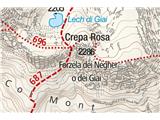
Interesting that on the Tabacco map Forc. dei Negher is marked differently than Forzela de Lech di Giai, named after the same lake on the northern side of the wall.
(+2)like
bagi5. 10. 2025 16:10:32
Kompass maps have a combination of both nasmeh
1
(+1)like
You must log in to post a comment:
Username:
Password:
Login
If you do not yet have a username, you must first register.
         
Copyright © 2026 Hiking-trail.net, Terms of use, Privacy and cookies