|
| aleš4318. 08. 2010 19:42:06 |
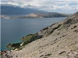
If you happen to be on summer holiday on Pag island, you must absolutely visit St. Vid, the highest peak of Pag island. Easy tour, but nice walk that rewards, in good weather, with beautiful views over the entire Pag island, Velebit Channel, islands ...
The first picture is the starting point Kolan
|
|
|
|
| sh18. 08. 2010 21:52:41 |
Photos that attract. This year we also watched Sv. Vid from the apartment in Gajac, if we go again we'll head to it too.
|
|
|
|
| SilvestrO19. 08. 2010 10:24:34 |
Aleš 43, even nicer approach is from the opposite side, from the sea (don't remember the place name), on steep marked path...(high mountain feeling)
sh,... years ago we watched the awakening in Gajac every morning from Sv. Vid and..., sunrises a few times...
|
|
|
|
| urosl19. 08. 2010 15:18:27 |
A few years ago two colleagues even got lost on that side towards Sv. Duh
|
|
|
|
| aleš4319. 08. 2010 19:53:20 |
of course I've also heard about the route from sv.Duh and from sv. Ane (along the ridge from Pag direction) I haven't tried them yet!
Next week I'm going from sv. Duh to try "climbing". so I'll report.. and pictures etc
|
|
|
|
| robi210721. 09. 2017 13:03:07 |
This year I was up there twice, first from Kolan side (starting point shown on picture 1 in route description), second from eastern side with starting point at Sv. Marija (picture 1 in description by vukovivek). Both times I reached the starting point by bike.
From Kolan side approach you could ride quite a while on fairly solid dirt road before further biking became impossible, continuation to top was completely easy walking on very gentle terrain. After cca. 10 min walk we reach junction where right towards Šumuni, left to top. Path is marked, even without it almost impossible to miss as soon we reach clearing and top in sight.
From eastern side completely different story. Path steep and partly on unstable terrain, several times need to grab some rock. As SilvesterO wrote on this page, ascent reminds of high mountains but not demanding, just some caution needed. Also from this direction path well marked, but on descent marks easy to overlook so more attention needed. Who goes up this side must reach starting point from south as road above Paški bay from north closed to cars for years due to road collapse. Can get around but needs quite some gymnastics and car won't thank you. For bike access no problem.
|
|
|
|
| Macesna22. 09. 2017 11:16:32 |
To Sv. Marija village, starting point for steeper path to Sv. Vid, from north side, one can also drive by car from Pag town. So not from Sv. Duh where road really closed to cars, but from other side, from Pag town. Road is OK, asphalted, just a bit narrow.
Path from north side and summit itself really nice, environment looks very high-alpine, below you see blue sea, really picturesque.
|
|
|
|
| robi210722. 09. 2017 13:23:55 |
Macesna, this explanation of yours won't hold entirely. If you look at the map you'll see that village Sv. Marija, starting point for ascent to Sv. Vid, is east of the "mountain", not north. Anyway, to the starting point (Sv. Marija) one can arrive from two sides: from south from Pag town, and from north, Novalja side, on gravel road that branches off from local road D106 before the hill. This is junction from north side, to road closure mentioned here, there is still quite some drive and it is actually placed much closer to Sv. Marija than to Sv. Duh. If memory serves, a little further from this closure (viewed from north side) since last year there is a marker indicating 15th meridian, then soon we reach starting point. As said, closure can be bypassed with car on some provisional detour a few meters higher above road and some do it, but I would rather not try, at least not with some lower or more expensive car. Maybe with some junker for 200 eur.
| (+1) |  | |
|
|
|
|
| Macesna22. 09. 2017 20:51:42 |
You are right, from Sv. Marija it is probably really the more eastern side. Anyway, I am just pointing out there is no need to struggle on the officially closed road since you can elegantly reach it on asphalt from Pag town.
 1 1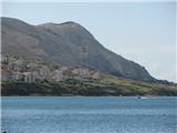 2 2
| (+2) | | |
|
|
|
|
| robi210723. 09. 2017 10:32:00 |
I agree with you as I actually wrote the same about access to the starting point from the south side myself. If someone vacations in the south part of the island or in Pag town, this is anyway the most logical choice. Those setting off from the north side of the island (I am already one such) would have to first go around the hill on the main road to Pag town, but that road is not flat at all and the path is much longer. For car drivers this plays no role and due to the mentioned road closure they actually have no other options, cyclists will surely prefer the descent to the bay from the mentioned junction on the north side as crossing the closure is no problem for them. I mentioned this option so no one thinks it is impossible to reach the starting point from this side AT ALL. It is possible, just not in principle with a car. It must also be said that the currently closed road between Sv. Duh and Pag town is the most popular bike path and the nicest panoramic road on the island. Locals since the collapse have been strongly pushing to reopen it. LP
|
|
|
|
| KarmenT2. 08. 2020 07:59:38 |
Yesterday to highest peak of Pag. Path very nicely marked, views boundless. Luckily pleasant breeze blew and eased heat. Sunrise wonderful. 
| (+1) | | |
|
|
|
|
| KarmenT3. 08. 2022 16:05:34 |
Miri, thanks! So they are close to each other.
|
|
|
|
| Lalala23. 08. 2022 16:22:59 |
Hi, can anyone tell me if the path is suitable for a dog - regarding the sharpness of the stones and rocks? Thanks
|
|
|
|
| geppo25. 08. 2022 09:56:16 |
Hi
I think the rocks aren't that sharply bad and you can go with a dog.
regards
| (+2) | | |
|
|
|
You must log in to post a comment:
If you do not yet have a username, you must first
register.