Vinišnik - Kremžarjev vrh
Starting point: Vinišnik (550 m)
Time of walking: 1 h 35 min
Difficulty: easy marked way
Altitude difference: 614 m
Altitude difference po putu: 615 m
Map: Pohorje 1:50.000
Recommended equipment (summer):
Recommended equipment (winter):
Views: 4.910
 | 1 person likes this post |
Access to the starting point:
a) From Velenje or Dravograd, drive to Slovenj Gradec and take the Kope and Legen exit at the roundabout on the main Dravograd - Velenje road. The road will then soon lead you to the next junction, where you turn right (towards the Kope ski centre). In this direction, drive for about 2. 2 km to the next crossroads, where you turn left (there are signs for some farms and a marked trail to Kremžarica). At the next crossroads, after 500 m, turn left again (towards the Vinišnik picnic area). Continue uphill for a short distance, meet a macadam road and on your left you will see a parking area.
b) From the regional road Mislinja - Slovenj Gradec, take the road to Šmartno pri Slovenj Gradcu and later Legen, pass the church of St. George and then turn right in the direction of the Kope ski centre. Continue in this direction for about 300 m to the next crossroads, where you turn left (there are signs for some farms in this direction and a marked trail to Kremžarca). At the next crossroads, after 500 m, turn left again in the direction of the Vinišnik picnic area. Continue uphill for a short distance, meet a macadam road and on your left you will see a parking area for hikers to Kremžarjev Vrch.
Path description:
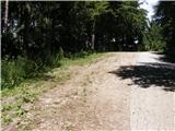
From the parking lot, continue along the road that leads to the Vinišnik picnic area. After a few minutes' walk, a signpost points the way to the right along a less steep road, past small farms. The road slowly turns into a forest logging trail or cart track. In this part, the path joins the road, starting from the farm Orešnik. A 40-minute walk uphill along the marked path, which follows the shaded cart track and a forest track. After completing the cart track, cross the junction of macadam roads where the "main road" leads to Sv. Barbara, and in the other direction to the valley or the hut below Kremžarjevi vrh. Our marked route continues on the other side of the road. In this part of the route you can observe Slovenj Gradec and the peaks of the nearby mountains (Uršlja gora, Peca). After 15 minutes of walking along the cart track and along the pastures past the Lampret farm, you cross the road and reach a crossroads. You have the option of taking a shorter route, either below the summit or directly to the summit.
A few steps to the right of Lampret Farm, climb over the upper road where the direct route to the summit is marked. The route to the top will take 35 minutes and takes you over short but steep climbs through the forest. The path through the forest slowly becomes cart track, winding along the hill meadow. From this meadow, a view slowly opens up from the top of Peć and Uršlá Gora to Slovenjgraje Airport in the lowlands. In this part of the trail, we join the trail from the Grmovski namai na Kopah. Continue walking along the meadow, keeping to the right-hand path, and walk to Kremžarjev Peak. If you continue on the path, you will descend to an undistinguished ridge on which there is an interesting semi-open glass chapel with a wishing bell, where the footpaths from Vuzenica and the path Vinišnik - Kremžarjev vrh (Under the top) join. You can continue on the horizontal path to the hut under Kremžarjevjevim vrh.

Pictures:
 1
1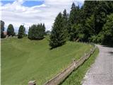 2
2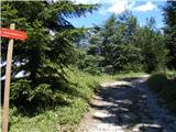 3
3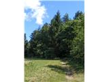 4
4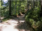 5
5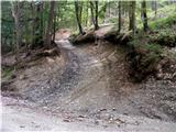 6
6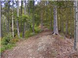 7
7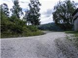 8
8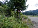 9
9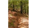 10
10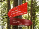 11
11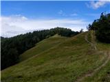 12
12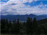 13
13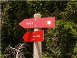 14
14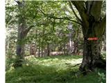 15
15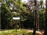 16
16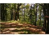 17
17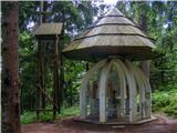 18
18
Discussion about the trail Vinišnik - Kremžarjev vrh
|
| timi_9514. 07. 2016 |
Pozdravljeni!
Ker se opisa ne da urejati objavlam Malce popravljen Dostop do izhodisca:
a) Iz Velenja ali Dravograda se zapeljemo v Slovenj Gradec, tu pa se v kroziscu, ki se nahaja na glavni cesti Dravograd - Velenje usmerimo na izvoz Kope in Legen. Cesta nas nato kmalu pripelje do naslednjega krizisca, kjer pa zavijemo desno (v smeri smucarskega centra Kope). V tej smeri se peljemo priblizno 2,2 km do naslednjega krizisca, kjer zavijemo LEVO (v to smer so smerokazi za nekaj kmetij in oznacena markirana pot za Kremzarico). V naslednjem kriziscu cez 500 m zopet zavijemo LEVO(v smeri piknik prostora Vinisnik). Nadaljujemo s krajso voznjo v klanec, se srecamo z makadamsko cesto in na levi strani opazimo parkirisce.
b) Z regionalne ceste Mislinja - Slovenj Gradec zapeljemo v naselje Smartno pri Slovenj Gradcu in pozneje Legen, peljemo se mimo cerkve sv. Jurija in nato zavijemo desno v smeri smucarskega centra Kope. V tej smeri nadaljujemo priblizno 300 m do naslednjega krizisca, kjer zavijemo levo (v to smer so smerokazi za nekaj kmetij in oznacena markirana pot za Kremzarco). V naslednjem krizisca cez 500 m zopet zavijemo LEVO v smeri piknik prostora Vinisnik. Nadaljujemo s krajso voznjo v klanec, se srecamo z makadamsko cesto in na levi strani opazimo parkirisce, ki je namenjeno pohodnikom na Kremzarjev Vrh.
Pot do vrha: Najprej se je treba zacet spuscat do koce. Bodite pozorni, ko se boste zaceli spuscati proti koci,je med spustom na desni strani odcep in markacije, ki oznacujejo Pot na vrh, do koce in v Vuzenico.
Pot je drugace cudovita, vecino po gozdu - senci in ni zahtevnih vzponov.
Se zahvaljujem za razumevanje
|
|
|
|
| Stamp17. 09. 2021 00:27:20 |
|
|
|