Studenice - Source of Topli (Studeniški) potok (Studenice - source of Topli potok - Zg. Poljčane)
Starting point: Studenice (260 m)
| Lat/Lon: | 46,2999°N 15,6138°E |
| |
Name of path: Studenice - source of Topli potok - Zg. Poljčane
Time of walking: 45 min
Difficulty: easy marked way
Altitude difference: 35 m
Altitude difference po putu: 125 m
Map: Posavsko hribovje Boč - Bohor 1:50.000
Recommended equipment (summer):
Recommended equipment (winter):
Views: 3.626
 | 2 people like this post |
Access to the starting point:
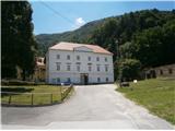
a) From the route of Ljubljana, leave the motorway at Slovenske Konjice and drive through Žič, Loč and Zbelovo to the centre of Poljčany. In the centre, turn right in the direction of Studenice and after about three kilometres reach Studenicee, where you continue to the right over the bridge over the Dravinja River into the central part of the settlement. Park safely in front of the monastery complex.
b) From Maribor, leave the motorway at Slovenska Bistrica, where signs direct you to Poljčane. In the centre, turn left towards Studenice and after about three kilometres reach Studenice, where you continue right over the bridge over the Dravinja River into the central part of the settlement. Park safely in front of the monastery complex.
c) From the direction of Ptuj, Kidričevo via Ptujska gora, Majšperk and Makole, arrive at Studenice, where you continue left over the bridge over the Dravinja river into the central part of the settlement. Park safely in front of the monastery complex.
Path description:
After a short tour of the central part of Studenice, we continue to the left of the monastery complex by the parish. In the passageway/underpass between the parish and the Studenicee Vineyarders' Association, continue up the cart track along the stone walls. The path to Studenice castle also branches off to the left, higher up and soon again to the left along the path a small stream with water flowing in a wooden trough. Further along the path on the right, enter through the iron gates, the old nun's cemetery of the Dominican and Magdalene nuns who have marked the history of Studenice over the turbulent centuries. Further left along the path, a stone and wood fountain and the remains of the reinforced concrete skeleton of the quarry. Somewhere the only "stranger", which somehow blended into the environment. A few more steps and the spring/springs of the stream are more or less rich in water. The world higher up is typically somewhere similar to a karst, limestone area and their water content depends on precipitation, melting snow. A few benches in an oasis of peace and quiet and a small wooden footbridge to cross the stream at higher water levels.
After a short visit, we continue upwards, now on the old Roman road, which has preserved the original form of the basic route higher up to Boč over the centuries. At the exit to the forest road turn right, on the left the road leads higher into the world of Boč, Donačka gora. . .
Continue along the well-fortified forest road, surrounded by deciduous woods, towards your destination. Soon we reach a plateau, to the right of the path vineyards and also a nice view down to Studenice, Makole. . . to the left of the path is a small hunters' warehouse. Continue and again in the embrace of the forest quite steeply downhill. Soon the world above Podboč opens up and the Dravinja River, Poljčane. . . Soon we reach the asphalt surface and the settlement Podboč itself, which has only a few houses or homesteads. On the right side of the path is Černog's yew tree and a fountain/student, restored a few years ago. Continue left and you will soon reach the village Zgornje Poljčane. On the right side of the path is the parish church of St. Cross with a rich history, a relief of two Romans is visible on the façade, and the old town centre, beautifully landscaped a few years ago. A few steps downhill, by the parish church on the right, and you reach the central part of Zgornje Poljčane, which is also the destination of the trail. The total length of the route from Studenice to Zgornje Poljčane is about 3500 metres, 125 positive vertical metres and 115 negative vertical metres, very suitable for mountain biking.

Pictures:
 1
1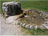 2
2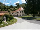 3
3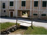 4
4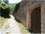 5
5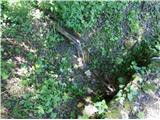 6
6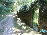 7
7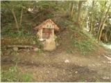 8
8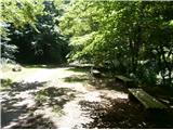 9
9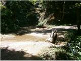 10
10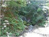 11
11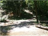 12
12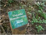 13
13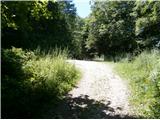 14
14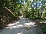 15
15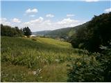 16
16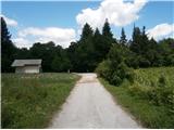 17
17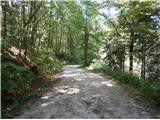 18
18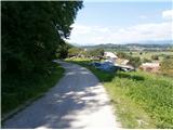 19
19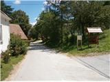 20
20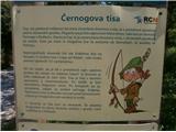 21
21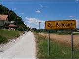 22
22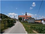 23
23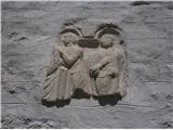 24
24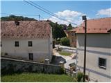 25
25 26
26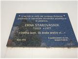 27
27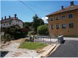 28
28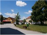 29
29
Discussion about the trail Studenice - Source of Topli (Studeniški) potok (Studenice - source of Topli potok - Zg. Poljčane)
|
| bruny19. 12. 2014 |
V nasprotni smeri opisa danes s kolesom v večernih urah v nekaj daljši kolesarski aktivnosti. Tudi nekoliko višje v Boč, bilo je izrazito vetrovno, noč kljub zvezdam na nebu temna, luna ni najbolj v pomoč s svetlobo v teh dneh...
|
|
|
|
| bruny17. 01. 2020 |
Po opisani poti zvečer v kratki aktivnosti...
|
|
|